

Surf Forecasts:

How big are the waves at Matanzas today (03 Aug):
- Morning surf: Morning surf (03 Aug, local time) - 7.5ft (2.3m), 12s period with W swell.
- Afternoon surf: Afternoon surf (03 Aug, local time) - 7ft (2.1m), 12s period with W swell.
- Evening surf: Evening surf (03 Aug, local time) - 7ft (2.2m), 12s period with W swell.
The current surf forecast for Matanzas at 12PM is: 2.2m 12s primary swell from a West direction and 0.6m 10s secondary swell from a Southwest direction (forecast issued at 07:00am August 03). The wind direction is predicted to be cross-shore.
| Time (-04) & Date | Wave Height | Wave Period |
|---|---|---|
| Morning (03 Aug) | 7.5ft (2.3m) | 12s |
| Afternoon (03 Aug) | 7ft (2.1m) | 12s |
| Evening (03 Aug) | 7ft (2.2m) | 12s |
Table - waves today at Matanzas. (Swell directed towards the surf break)
Short Range ForecastModerate rain (total 13mm), heaviest on Wed night. Very mild (max 17°C on Mon afternoon, min 10°C on Wed night). Mainly fresh winds. | |||||||||||||||||||||||
Monday 3 | Tuesday 4 | Wednesday 5 | |||||||||||||||||||||
5 AM | 8 AM | 11 AM | 2 PM | 5 PM | 8 PM | 11 PM | 2 AM | 5 AM | 8 AM | 11 AM | 2 PM | 5 PM | 8 PM | 11 PM | 2 AM | 5 AM | 8 AM | 11 AM | 2 PM | 5 PM | 8 PM | 11 PM | |
Swell Height Map |  |  | 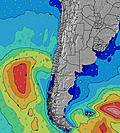 |  |  |  |  | 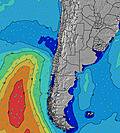 |  | ||||||||||||||
Wave Height (m) Direction Period (s) | W 12 | W 12 | W 12 | W 12 | W 12 | W 12 | WSW 12 | WSW 12 | WSW 12 | WSW 12 | WSW 12 | WSW 12 | WSW 12 | WSW 12 | WSW 12 | WSW 13 | WSW 12 | WSW 12 | WSW 12 | WSW 11 | WSW 14 | WSW 14 | WSW 14 |
Wave Graph | |||||||||||||||||||||||
1721 | 1494 | 1369 | 1249 | 1290 | 1435 | 1485 | 1485 | 1338 | 1220 | 1090 | 1121 | 1053 | 902 | 887 | 1198 | 1290 | 1358 | 1401 | 1064 | 943 | 1826 | 3033 | |
Wind (km/h) | |||||||||||||||||||||||
Wind State on-shore cross-onshore cross-shore cross-offshore off-shore glassy | cross-off | cross-off | cross-on | cross | cross-off | cross-off | glassy | glassy | cross-on | cross | cross-on | cross-on | cross | cross | cross | cross-off | glassy | glassy | on | cross | cross | cross-on | cross |
High Tide | 1:08PM1.21m | 1:48AM1.08m | 1:46PM1.10m | 2:34AM1.11m | 2:34PM0.97m | ||||||||||||||||||
Low Tide | 6:54AM0.29m | 7:33PM0.19m | 7:43AM0.35m | 8:06PM0.24m | 8:44AM0.40m | 8:47PM0.29m | |||||||||||||||||
7:37 | — | — | — | — | — | — | — | 7:37 | — | — | — | — | — | — | — | 7:35 | — | — | — | — | — | — | |
— | — | — | — | 6:08 | — | — | — | — | — | — | — | 6:09 | — | — | — | — | — | — | — | 6:09 | — | — | |
mm | — | — | — | — | — | — | — | — | — | — | — | — | — | — | — | — | — | — | — | — | — | 3 | 9 |
Temp °C | 14 | 14 | 15 | 17 | 17 | 16 | 15 | 14 | 14 | 13 | 14 | 15 | 14 | 13 | 13 | 14 | 14 | 14 | 15 | 15 | 14 | 11 | 11 |
Feels °C | 13 | 13 | 14 | 15 | 15 | 14 | 14 | 14 | 13 | 12 | 12 | 12 | 11 | 10 | 11 | 13 | 14 | 14 | 14 | 12 | 10 | 5 | 6 |
Swell 1 Height (m) Direction Period (s) | W 12 | W 12 | W 12 | W 12 | W 12 | W 12 | WSW 12 | WSW 12 | WSW 12 | WSW 12 | WSW 12 | WSW 12 | WSW 12 | WSW 12 | WSW 12 | WSW 13 | WSW 12 | WSW 12 | WSW 12 | WSW 11 | WSW 14 | NW 12 | WSW 14 |
1721 | 1494 | 1369 | 1249 | 1290 | 1435 | 1485 | 1485 | 1338 | 1220 | 1090 | 1121 | 1053 | 902 | 887 | 1198 | 1290 | 1358 | 1401 | 1064 | 943 | 5 | 3033 | |
Swell 2 Height (m) Direction Period (s) | — | SW 10 | SW 10 | SW 10 | SW 9 | SW 9 | SW 20 | SSW 8 | SSW 8 | SW 20 | SW 20 | SW 19 | SW 19 | SW 19 | SW 18 | WSW 18 | WSW 18 | SW 17 | NW 11 | WSW 16 | WSW 10 | — | NW 12 |
— | 98 | 79 | 73 | 39 | 20 | 16 | 6 | 6 | 61 | 97 | 95 | 94 | 170 | 155 | 209 | 209 | 138 | 5 | 532 | 443 | — | 5 | |
Swell 3 Height (m) Direction Period (s) | — | — | — | — | — | — | — | WSW 20 | WSW 20 | — | — | NW 12 | NW 12 | NW 11 | NW 11 | NW 12 | NW 12 | NW 11 | — | NW 12 | NW 12 | — | — |
— | — | — | — | — | — | — | 39 | 39 | — | — | 6 | 6 | 5 | 5 | 5 | 5 | 5 | — | 5 | 6 | — | — | |
Wind waves Height (m) Direction Period (s) | — | — | — | — | — | — | — | — | — | — | — | — | — | — | — | — | — | — | — | — | — | WSW 14 | — |
— | — | — | — | — | — | — | — | — | — | — | — | — | — | — | — | — | — | — | — | — | 1826 | — | |
Nearest Offshore or Glassy | |||||||||||||||||||||||
Distance (km) | 0 | 0 | 43 | 43 | 0 | 0 | 0 | 0 | 48 | 16 | 48 | 121 | 121 | 48 | 48 | 0 | 0 | 0 | 55 | 59 | 79 | 118 | 248 |
Best forecast wave conditions in Santiago | |||||||||||||||||||||||
Best forecast wave conditions in Chile | |||||||||||||||||||||||
Header Global | |||||||||||||||||||||||
- Map Icons:
 Break
Break Live Wave Height (m)
 Live Wind Speed (km/h)
 Surf Rating (10 Max)
 Ocean Swells (m)
- Wind Speed (km/h)
Latest Updates


FREE! Surf-Forecast.com widget for your website
The surf report / weather widget below is available to embed on third party websites free of charge and provides a summary of our Matanzas surf forecast. Simply grab the html code snippet that we provide and paste it into your own site. You can choose your preferred language and metric/imperial units for the surf forecast feed to suit users of your site. Click here to get the code.
 Nearest