

Surf Forecasts:

How big are the waves at Mapelane today (03 Aug):
- Morning surf: Morning surf (03 Aug, local time) - 8ft (2.4m), 11s period with SE swell.
- Afternoon surf: Afternoon surf (03 Aug, local time) - 7ft (2.1m), 10s period with SE swell.
- Evening surf: Evening surf (03 Aug, local time) - 6ft (1.8m), 10s period with SE swell.
The current surf forecast for Mapelane at 7AM is: 2.5m 11s primary swell from a Southeast direction and 0.3m 11s secondary swell from a South direction (forecast issued at 01:00am August 03). The wind direction is predicted to be offshore and the swell rating is 4.
| Time (SAST) & Date | Wave Height | Wave Period |
|---|---|---|
| Morning (03 Aug) | 8ft (2.4m) | 11s |
| Afternoon (03 Aug) | 7ft (2.1m) | 10s |
| Evening (03 Aug) | 6ft (1.8m) | 10s |
Table - waves today at Mapelane. (Swell directed towards the surf break)
Short Range ForecastMostly dry. Warm (max 24°C on Wed afternoon, min 18°C on Mon morning). Winds increasing (calm on Tue morning, fresh winds from the NE by Wed afternoon). | ||||||||||||||||||||||||
Monday 3 | Tuesday 4 | Wednesday 5 | ||||||||||||||||||||||
2 AM | 5 AM | 8 AM | 11 AM | 2 PM | 5 PM | 8 PM | 11 PM | 2 AM | 5 AM | 8 AM | 11 AM | 2 PM | 5 PM | 8 PM | 11 PM | 2 AM | 5 AM | 8 AM | 11 AM | 2 PM | 5 PM | 8 PM | 11 PM | |
Swell Height Map |  |  |  |  | 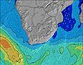 |  |  | 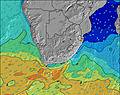 |  | |||||||||||||||
Wave Height (m) Direction Period (s) | SE 11 | SE 11 | SE 11 | SE 11 | SE 10 | SE 10 | SE 10 | SE 10 | SE 10 | SE 10 | SE 10 | SE 10 | ESE 10 | ESE 10 | ESE 10 | ESE 10 | ESE 10 | ESE 10 | ESE 10 | ESE 10 | ESE 10 | ESE 10 | ESE 10 | ESE 10 |
Wave Graph | ||||||||||||||||||||||||
1976 | 1701 | 1411 | 1132 | 1001 | 784 | 663 | 602 | 557 | 592 | 549 | 500 | 457 | 419 | 327 | 296 | 269 | 210 | 210 | 197 | 193 | 150 | 150 | 154 | |
Wind (km/h) | ||||||||||||||||||||||||
Wind State on-shore cross-onshore cross-shore cross-offshore off-shore glassy | cross-off | off | off | cross-off | cross-off | cross | cross | off | cross-off | cross-off | glassy | cross-on | on | on | cross-on | cross-on | cross-on | cross-on | cross | cross-on | cross-on | cross-on | cross-on | cross |
High Tide | 6:09AM1.85m | 6:32PM1.90m | 6:41AM1.75m | 7:06PM1.80m | 7:18AM1.62m | 7:48PM1.66m | ||||||||||||||||||
Low Tide | 00:07AM0.21m | 12:17PM0.15m | 00:40AM0.28m | 12:50PM0.24m | 1:17AM0.39m | 1:28PM0.37m | ||||||||||||||||||
— | 6:31 | — | — | — | — | — | — | — | 6:31 | — | — | — | — | — | — | — | 6:30 | — | — | — | — | — | — | |
— | — | — | — | — | 5:21 | — | — | — | — | — | — | — | 5:21 | — | — | — | — | — | — | — | 5:22 | — | — | |
mm | 1 | — | — | — | — | — | — | — | — | — | — | — | — | — | — | — | — | — | — | — | — | — | — | — |
Temp °C | 18 | 18 | 18 | 21 | 21 | 21 | 20 | 20 | 18 | 18 | 18 | 20 | 22 | 21 | 21 | 20 | 19 | 18 | 18 | 22 | 24 | 22 | 21 | 20 |
Feels °C | 16 | 16 | 16 | 20 | 19 | 20 | 20 | 21 | 18 | 19 | 19 | 19 | 20 | 19 | 19 | 18 | 17 | 15 | 15 | 19 | 20 | 20 | 19 | 18 |
Swell 1 Height (m) Direction Period (s) | SE 11 | SE 11 | SE 11 | SE 11 | SE 10 | SE 10 | SE 10 | SE 10 | SE 10 | SE 10 | SE 10 | SE 10 | ESE 10 | ESE 10 | ESE 10 | ESE 10 | ESE 10 | ESE 10 | ESE 10 | ESE 10 | ESE 10 | ESE 10 | ESE 10 | ESE 10 |
1976 | 1701 | 1411 | 1132 | 1001 | 784 | 663 | 602 | 557 | 592 | 549 | 500 | 457 | 419 | 327 | 296 | 269 | 210 | 210 | 197 | 193 | 150 | 150 | 154 | |
Swell 2 Height (m) Direction Period (s) | S 14 | S 13 | S 11 | S 10 | S 10 | S 10 | SSW 16 | SSW 16 | SW 15 | SW 15 | SSW 14 | SSW 13 | SSW 13 | SSW 13 | SSW 13 | SSW 12 | SSW 12 | SSW 12 | SSW 12 | SSW 12 | SSW 12 | SSW 12 | SSW 11 | SSW 16 |
15 | 14 | 22 | 19 | 18 | 18 | 50 | 47 | 54 | 54 | 40 | 35 | 35 | 34 | 33 | 15 | 14 | 14 | 14 | 14 | 14 | 13 | 12 | 26 | |
Swell 3 Height (m) Direction Period (s) | S 16 | SW 16 | SSW 15 | SSW 15 | SSW 15 | SSW 16 | S 10 | S 10 | S 10 | S 10 | S 10 | S 10 | S 11 | S 11 | S 11 | S 12 | SSE 12 | SE 12 | S 12 | SE 11 | S 11 | S 18 | SW 16 | SSW 11 |
5 | 10 | 21 | 21 | 22 | 50 | 18 | 18 | 18 | 8 | 9 | 8 | 9 | 2 | 2 | 11 | 14 | 6 | 3 | 4 | 2 | 6 | 11 | 12 | |
Wind waves Height (m) Direction Period (s) | SW 5 | — | — | — | — | — | — | — | — | — | — | — | — | ENE 3 | ENE 4 | NE 4 | NE 4 | NNE 4 | NNE 4 | NNE 5 | NE 5 | NE 6 | NE 6 | NNE 6 |
22 | — | — | — | — | — | — | — | — | — | — | — | — | 3 | 11 | 15 | 16 | 17 | 25 | 31 | 53 | 101 | 98 | 80 | |
Nearest Offshore or Glassy | ||||||||||||||||||||||||
Distance (km) | 90 | 0 | 0 | 0 | 212 | 55 | 55 | 0 | 0 | 0 | 0 | 3 | 212 | 212 | 104 | 104 | 104 | 90 | 90 | 55 | 212 | 212 | 90 | 90 |
Best forecast wave conditions in KwaZulu-Natal North Coast | ||||||||||||||||||||||||
Best forecast wave conditions in South Africa | ||||||||||||||||||||||||
Header Global | ||||||||||||||||||||||||
- Map Icons:
 Break
Break Live Wave Height (m)
 Live Wind Speed (km/h)
 Surf Rating (10 Max)
 Ocean Swells (m)
- Wind Speed (km/h)
Latest Updates


FREE! Surf-Forecast.com widget for your website
The surf report / weather widget below is available to embed on third party websites free of charge and provides a summary of our Mapelane surf forecast. Simply grab the html code snippet that we provide and paste it into your own site. You can choose your preferred language and metric/imperial units for the surf forecast feed to suit users of your site. Click here to get the code.
 Nearest