

Surf Forecasts:

Jarosite Reef surf forecast from 3 Aug 2026:
- Best quality surf: Monday 10 Aug, 4PM (local time) - 16ft (5.0m), 16s period, WSW swell with offshore winds.
- Most powerful swell: Monday 10 Aug, 4PM (local time) - 16ft (5.0m), 16s period, WSW swell with 12,645 kJ wave energy.
- Next surfable swell (1★+): Tuesday 4 Aug, 4AM (local time) - 3.5ft (1.1m), 12s period with SW swell.
Best Forecast Surf Conditions for Jarosite Reef this week:
The surf forecast for Jarosite Reef over the next 16 days: The first swell (rated 1 star or higher) is forecast to arrive on Tuesday (Aug 04) at 4AM. The primary swell is predicted to be 1.1m and 12s period with a secondary swell of 0.5m and 17s. The wind is predicted to be offshore as the swell arrives.
The most powerful waves expected at Jarosite Reef in the next 16 days are 5.0m 16s and forecast to arrive on Monday (Aug 10) at 4PM. Winds are predicted to be offshore at the time the swell arrives. The largest open ocean swell (not directed at the beach) is 1.1m 5s period and expected on Sunday (Aug 09) at 7AM.
| Wave Type | Time (AEST) & Date | Wave Height & Period |
|---|---|---|
| Next good surf (1 star+) | 4AM (Tue 4th Aug) | 3.5ft (1.1m) 12s |
| Best Surf | 4PM (Mon 10th Aug) | 16ft (5.0m) 16s |
| Most Powerful | 4PM (Mon 10th Aug) | 16ft (5.0m) 16s |
Table - best surf conditions forecast for Jarosite Reef over the next 16 days.
The Lowdown
Alright, crew, Rusty here. Let’s have a look at what old man ocean has in store for us over the next couple of weeks. We’ve got one spot on the radar, and it’s got some serious potential if you know what you’re doing. We’re looking at Jarosite Reef, a heavy, expert-only wave that demands respect. It’s exposed to the southwest swell, and it likes it from that direction. The water is about what you’d expect for this time of year, no weird anomalies to talk about.
For the next few days, the surf is going to be pretty hit-or-miss. We’ve got some chest to head-high swell moving through, and it’s roasting out of the southwest with a mix of groundswell energy. The wind is mostly sideshore or a light cross-off, which will keep things reasonably clean. The energy is moderate, with readings around 476 to 768. It’s surfable, but nothing to write home about. The swell period is a solid 12 seconds, so there’s some push behind it. As we get into Wednesday, the swell jumps a bit and the period stretches out to 14 seconds, which adds some power. The energy gets more serious, hitting 1721 on Wednesday morning. It’ll be a bit inconsistent, and the conditions might not be perfect, but there are waves to be had if you’re keen. Thursday sees a drop-off in size with some long-period 16-second swell, but the energy falls away to a weak 213. This is where it gets a bit slow. The morning looks clean with a light offshore wind, but the afternoon gets a bit cross-y. It’s a bit of a lull, to be honest. Friday is similar, a bit small but with some clean morning conditions and a light breeze. Energy is moderate at 524.
Now, check this out. The first big standout window looks like it’s coming up on the 10th of August. There’s a rapid change in the forecast. We start the day with a solid 7ft of SW swell, but by the afternoon, the bottom drops out and the ocean just lights up. We’re talking a massive 16ft of WSW swell, ramping up with a 16-second period. The energy reading is a staggering 15973, which is just insane. The wind is offshore and favorable, creating what the models call a “moderate offshore and clean” setup. The only problem, and it’s a big one, is the swell is predicted to be too big for this break. It's a freight train. This is a day for the true chargers, and even then, it might be beyond the limit. It’s not a beginner’s day and it’s probably only for experts. That’s the one to circle on your calendar. It’s a monster.
After that pulse, it backs down to a still-chunky 6ft to 8ft for the next couple of days. The period stays long at 15-16 seconds. Wednesday the 12th is looking like a highlight, with a solid 8ft of SW swell and clean conditions in the morning, and an energy reading of 2935. The winds are light and offshore. It’s going to be powerful and lined-up, perfect for a high-performance reef like this. That morning is going to be the pick of that stretch.
Then, hold on to your boardshorts. The next Monday, the 13th of August, brings another massive pulse. We’re looking at an 12ft SSW groundswell with a long 16-second period. The energy is huge, with readings around 7178 in the morning, and the winds are light and offshore. The report says “exceptional surf conditions for expert surfers.” This is another serious swell event. This is the second standout. It’s big and it’s perfect. The period is so long, it might be breaking a bit too straight on a reef, but that’s a small caveat for a day like this. It’s going to be glorious and terrifying.
From there, the swell slowly backs off into the second week. Friday the 14th still has a solid 6ft of SSW swell and good clean morning conditions. By the weekend, we’re back to the 4ft to 4ft range, but with an almost dead calm wind and even a glassy period on Saturday afternoon. It’ll be clean, but smaller and less powerful. The following week looks a bit patchy, with a couple of average days and some weaker, shorter-period swell moving in. The long-range stuff looks promising but less certain.
So, to sum it up: there’s a fun but not spectacular start, then two massive, significant swell events on the 10th and the 13th of August. Those are the standouts. The 13th is likely the best on offer, all things considered. For anyone else, the surf will get good again towards the end of the week and into the weekend, but you gotta be patient.
Stay salty.
Rusty
Short Range ForecastLight rain (total 7mm), mostly falling on Mon night. Very mild (max 13°C on Wed afternoon, min 7°C on Mon night). Wind will be generally light. | Days 5-7 Weather SummaryModerate rain (total 13mm), heaviest on Sun morning. Very mild (max 16°C on Sat morning, min 9°C on Sun afternoon). Winds increasing (light winds from the NW on Fri afternoon, fresh winds from the N by Sat night). | ||||||||||||||||||
Tuesday 4 | Wednesday 5 | Thursday 6 | Friday 7 | Saturday 8 | Sunday 9 | ||||||||||||||
Night | AM | PM | Night | AM | PM | Night | AM | PM | Night | AM | PM | Night | AM | PM | Night | AM | PM | Night | |
Swell Height Map |  |  |  |  | 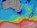 | 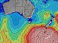 | 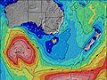 | ||||||||||||
Wave Height (m) Direction Period (s) | WSW 13 | SW 12 | SW 12 | SW 10 | SW 14 | SW 14 | SW 17 | SW 16 | SW 16 | SW 18 | SW 16 | SW 15 | SW 18 | SW 16 | SW 16 | SW 15 | SW 14 | SW 14 | SW 16 |
Wave Graph | |||||||||||||||||||
2402 | 409 | 644 | 577 | 1107 | 810 | 147 | 203 | 198 | 300 | 480 | 313 | 588 | 574 | 553 | 309 | 251 | 269 | 651 | |
Wind (km/h) | |||||||||||||||||||
Wind State on-shore cross-onshore cross-shore cross-offshore off-shore glassy | cross-off | off | cross-off | cross-off | cross-off | cross-off | cross-off | off | cross-off | cross-off | cross-off | cross-off | cross-off | cross-off | cross-off | cross-off | cross-off | cross-off | cross-off |
High Tide | 3:11AM1.69m | 3:22PM1.87m | 3:50AM1.75m | 3:48PM1.85m | 4:31AM1.80m | 4:16PM1.83m | 5:15AM1.81m | 4:48PM1.80m | 6:04AM1.79m | 5:24PM1.75m | 7:02AM1.74m | 6:09PM1.69m | |||||||
Low Tide | 9:09AM0.45m | 9:40PM0.35m | 9:45AM0.51m | 10:11PM0.26m | 10:22AM0.60m | 10:45PM0.19m | 11:02AM0.70m | 11:24PM0.14m | 11:46AM0.81m | 00:11AM0.13m | 12:38PM0.93m | 1:07AM0.16m | |||||||
— | 7:22 | — | — | 7:20 | — | — | 7:20 | — | — | 7:18 | — | — | 7:16 | — | — | 7:16 | — | — | |
— | — | 5:36 | — | — | 5:37 | — | — | 5:37 | — | — | 5:37 | — | — | 5:38 | — | — | 5:39 | — | |
mm | 2 | 2 | 2 | 1 | — | — | — | — | — | — | — | — | — | — | 2 | 5 | 4 | 2 | 2 |
Temp °C | 9 | 12 | 12 | 10 | 12 | 13 | 11 | 12 | 12 | 11 | 12 | 13 | 12 | 16 | 13 | 13 | 12 | 11 | 10 |
Feels °C | 5 | 7 | 7 | 6 | 8 | 9 | 8 | 7 | 9 | 8 | 8 | 9 | 9 | 10 | 7 | 6 | 6 | 4 | 3 |
Swell 1 Height (m) Direction Period (s) | SW 13 | SW 12 | SW 16 | SW 10 | SSW 15 | SSW 9 | SW 13 | SW 16 | SW 16 | SW 18 | SW 16 | SW 15 | SW 18 | SW 16 | SW 16 | SW 15 | SW 14 | SW 14 | SW 16 |
352 | 409 | 119 | 229 | 455 | 121 | 106 | 203 | 198 | 300 | 480 | 313 | 588 | 574 | 553 | 309 | 251 | 269 | 651 | |
Swell 2 Height (m) Direction Period (s) | WSW 13 | SW 16 | S 16 | SW 15 | SW 20 | SW 14 | SW 17 | S 5 | SW 6 | SSW 5 | S 6 | S 7 | S 7 | S 7 | S 6 | — | — | NNE 5 | SW 20 |
120 | 67 | 5 | 54 | 98 | 167 | 147 | 5 | 9 | 24 | 26 | 32 | 24 | 8 | 3 | — | — | 2 | 251 | |
Swell 3 Height (m) Direction Period (s) | SW 17 | N 4 | — | SW 21 | SW 11 | SW 18 | SW 8 | S 16 | S 8 | SW 14 | SW 6 | SW 19 | — | — | — | — | — | NE 6 | — |
148 | 2 | — | 109 | 61 | 166 | 32 | 5 | 1 | 73 | 18 | 231 | — | — | — | — | — | 1 | — | |
Wind waves Height (m) Direction Period (s) | WSW 13 | WNW 3 | SW 12 | SW 10 | SW 14 | SW 14 | — | NW 2 | W 2 | SW 5 | — | — | — | ESE 7 | NNE 4 | NNE 4 | NNE 5 | WNW 3 | NW 3 |
2402 | 3 | 644 | 577 | 1107 | 810 | — | 1 | 1 | 56 | — | — | — | 15 | 10 | 17 | 52 | 5 | 8 | |
Nearest Offshore or Glassy | |||||||||||||||||||
Distance (km) | 8 | 0 | 10 | 8 | 8 | 8 | 0 | 0 | 8 | 0 | 0 | 0 | 0 | 8 | 28 | 169 | 525 | 236 | 358 |
Best forecast wave conditions in Torquay | |||||||||||||||||||
Best forecast wave conditions in Australia | |||||||||||||||||||
Header Global | |||||||||||||||||||
- Map Icons:
 Break
Break Live Wave Height (m)
 Live Wind Speed (km/h)
 Surf Rating (10 Max)
 Ocean Swells (m)
- Wind Speed (km/h)
Latest Updates


FREE! Surf-Forecast.com widget for your website
The surf report / weather widget below is available to embed on third party websites free of charge and provides a summary of our Jarosite Reef surf forecast. Simply grab the html code snippet that we provide and paste it into your own site. You can choose your preferred language and metric/imperial units for the surf forecast feed to suit users of your site. Click here to get the code.
Information about the Jarosite Reef Surf forecast
The above surf forecast table for Jarosite Reef provides essential information for determining whether the surfing conditions will be good over the next 16 days. A general guide to surfing at Jarosite Reef can be found by selecting the local surf guide option on the grey menu. Our Jarosite Reef surf forecast is unique since it includes wave energy (power) that defines the real feel of the surf rather than just the height or the period. If you surf the same spot (Jarosite Reef) regularly then make a mental note of the wave energy from the surf forecast table each time you go. Very soon you may start to choose your surf days based on the wave energy alone combined with our forecast of favourable offshore wind conditions. Our star ratings will help here and of course you will also find the usual wave height and period predictions on our surf forecasts as well as a full break down of the swell components under our advanced users option (to reveal that, click the little Einstein character under the tide times).
Further information to help with frequently asked questions about our surf forecast for Jarosite Reef may be found under the help tab on the top menu and also by moving your mouse over the question marks on the surf forecast table itself. Please always bear in mind that the forecast is for near-shore open water and local factors at each surf break influence the actual breaking wave height, such as the beach / reef profile, water depths offshore and shelter.
Jarosite Reef is 27 km (17 miles) from the city of Geelong. If you plan a holiday in Torquay, look for hotels and other accommodation in Geelong. Geelong has rooms for a wide range of budgets as well as car hire and transport links.
 Nearest