

Surf Forecasts:

Honkeys surf forecast from 3 Aug 2026:
- Most powerful swell: Wednesday 5 Aug, 5PM (local time) - 4ft (1.2m), 18s period, SSW swell with 861 kJ wave energy.
Best Forecast Surf Conditions for Honkeys this week:
The most powerful waves expected at Honkeys in the next 16 days are 1.2m 18s and forecast to arrive on Wednesday (Aug 05) at 5PM. Winds are predicted to be cross-onshore at the time the swell arrives. The largest open ocean swell (not directed at the beach) is 1.5m 9s period and expected on Monday (Aug 03) at 11AM.
| Wave Type | Time (+05) & Date | Wave Height & Period |
|---|---|---|
| Next good surf (1 star+) | - | - |
| Best Surf | - | - |
| Most Powerful | 5PM (Wed 5th Aug) | 4ft (1.2m) 18s |
Table - best surf conditions forecast for Honkeys over the next 16 days.
The Lowdown
Alright folks, Rusty here. Let’s be straight with you – this 16-day run for Honkeys is a tough one. We’re looking at a long stretch of poor conditions that doesn’t really let up until the very end. The first recommendation we get isn’t until the morning of Saturday the 15th of August, so that’s a solid 12-day gap with nothing worth paddling out for. Honestly, the first two weeks are a write-off, with moderate to fresh cross-onshore winds junking up the waves and the energy feeling weak to moderate for the most part. The water temp is sitting at 85°F which is about normal for the time of year, but you won’t be feeling it much with that wind in your face.
Things finally start to shift around the 15th. Saturday morning, the 15th of August, brings a little hope. We’ve got a 5ft swell from the SE, mixed with a cross-onshore wind that’s only a light breeze at 6 mph. The conditions are still marginal, but that’s a big improvement. The combined energy is moderate (619), and it’s a South-facing reef, so the swell direction isn’t a perfect match, but the drop in wind makes it the most interesting day of the whole outlook. The afternoon sees the wind turning onshore, but it’s still light.
The best of the whole run, and the only real standout, is the morning of Monday the 17th of August. We’ve got a 3ft swell from the SSW with a period of 14 seconds – that’s a proper groundswell. The wind is glassy, light and variable from the WSW at 6 mph, going onshore, which should keep the surface clean for a reef break like Honkeys. The water is still warm. The energy is moderate (625) and the wave comment finally gets a ‘2’ rating, which is the best we’ll see. It’s a small, clean day for the longboard or a fun fish. The following Tuesday morning also looks clean with very light winds, but the swell is dropping to 3ft.
Don’t get too excited about the bigger pulses in the first week, like the 5ft to 6ft stuff. The cross-onshore winds were just too strong and the wave comment was always “poor surf conditions”. That’s a miss. For a beginner, anything over 5ft is a bit much, and with the wind, it’s a no-go. For the experts, there’s nothing with enough quality until that last weekend.
So, to sum it up: the first two weeks are a bust. The last few days, from the 15th to the 18th, have some clean, small windows if you’re patient and don’t mind scaling down the board. It’s not a call to arms, but it’s a chance to get wet without getting chewed up.
Rusty.
Short Range ForecastModerate rain (total 12mm), heaviest on Mon morning. Warm (max 28°C on Mon night, min 27°C on Mon morning). Mainly fresh winds. | Days 4-6 Weather SummaryModerate rain (total 10mm), heaviest on Thu night. Warm (max 28°C on Thu morning, min 27°C on Thu night). Wind will be generally light. | ||||||||||||||||||||
Monday 3 | Tuesday 4 | Wednesday 5 | Thursday 6 | Friday 7 | Saturday 8 | Sunday 9 | |||||||||||||||
AM | PM | Night | AM | PM | Night | AM | PM | Night | AM | PM | Night | AM | PM | Night | AM | PM | Night | AM | PM | Night | |
Swell Height Map | 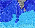 |  | 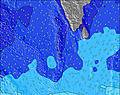 | 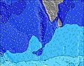 | 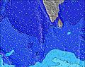 |  |  | ||||||||||||||
Wave Height (m) Direction Period (s) | SW 16 | SSW 17 | SSW 16 | SSW 16 | SSW 15 | SW 15 | SSW 19 | SSW 18 | SSW 17 | S 16 | S 10 | S 10 | S 11 | S 11 | S 11 | S 11 | S 10 | S 10 | S 10 | SSE 10 | SSE 10 |
Wave Graph | |||||||||||||||||||||
203 | 657 | 604 | 662 | 612 | 323 | 627 | 861 | 647 | 246 | 296 | 319 | 546 | 475 | 610 | 673 | 543 | 476 | 506 | 418 | 410 | |
Wind (km/h) | |||||||||||||||||||||
Wind State on-shore cross-onshore cross-shore cross-offshore off-shore glassy | cross-on | cross-on | cross | cross-on | cross-on | cross-on | cross-on | cross-on | cross-on | cross-on | cross-on | cross-on | cross-on | cross-on | cross-on | on | on | cross-on | cross-on | cross-on | cross-on |
High Tide | 3:30PM0.89m | 4:15AM0.79m | 3:50PM0.83m | 4:59AM0.77m | 4:09PM0.77m | 5:55AM0.72m | 4:24PM0.70m | 7:21AM0.68m | 4:26PM0.63m | 9:43AM0.69m | 11:21AM0.76m | 9:03PM0.48m | |||||||||
Low Tide | 9:20AM0.24m | 9:54PM0.13m | 9:53AM0.31m | 10:23PM0.12m | 10:28AM0.39m | 10:56PM0.12m | 11:09AM0.48m | 11:37PM0.14m | 12:11PM0.56m | 00:38AM0.18m | 2:24AM0.20m | 7:08PM0.48m | 4:18AM0.18m | ||||||||
6:01 | — | — | 6:01 | — | — | 6:01 | — | — | 6:01 | — | — | 6:01 | — | — | 6:01 | — | — | 6:01 | — | — | |
— | 6:20 | — | — | 6:20 | — | — | 6:20 | — | — | 6:20 | — | — | 6:20 | — | — | 6:19 | — | — | 6:19 | — | |
mm | 2 | — | — | — | 1 | 6 | 3 | — | — | — | — | 1 | 2 | 2 | 2 | — | — | 3 | — | 1 | — |
Temp °C | 27 | 27 | 28 | 27 | 28 | 28 | 27 | 28 | 28 | 28 | 28 | 28 | 27 | 28 | 28 | 27 | 28 | 28 | 27 | 27 | 28 |
Feels °C | 29 | 27 | 29 | 28 | 29 | 29 | 27 | 28 | 28 | 29 | 28 | 28 | 27 | 28 | 28 | 27 | 29 | 29 | 27 | 28 | 29 |
Swell 1 Height (m) Direction Period (s) | WNW 9 | WNW 9 | WNW 9 | SSW 16 | SSW 15 | SW 15 | WNW 8 | SSW 18 | SSW 17 | WNW 8 | S 10 | S 10 | S 11 | S 11 | S 11 | S 11 | S 10 | S 10 | S 10 | SSE 10 | SSE 10 |
387 | 354 | 286 | 662 | 612 | 314 | 254 | 861 | 647 | 161 | 296 | 319 | 546 | 475 | 610 | 673 | 543 | 476 | 506 | 418 | 410 | |
Swell 2 Height (m) Direction Period (s) | SSE 8 | SSW 17 | SSW 16 | SSE 8 | SSE 8 | S 17 | SSW 15 | S 10 | S 10 | S 9 | WNW 8 | WNW 7 | WNW 8 | WNW 10 | NW 9 | NW 9 | NW 8 | NW 8 | NW 10 | NW 10 | NW 10 |
137 | 657 | 604 | 75 | 67 | 204 | 353 | 100 | 192 | 217 | 159 | 104 | 103 | 161 | 112 | 112 | 80 | 99 | 173 | 167 | 154 | |
Swell 3 Height (m) Direction Period (s) | SW 16 | SSE 8 | SSE 8 | SE 9 | E 9 | S 21 | SSW 19 | WNW 10 | WNW 10 | S 16 | SW 16 | SSW 14 | S 18 | S 17 | S 18 | S 17 | S 17 | S 16 | S 18 | S 17 | S 23 |
203 | 111 | 108 | 3 | 2 | 323 | 627 | 42 | 39 | 246 | 196 | 138 | 229 | 291 | 156 | 138 | 87 | 77 | 154 | 154 | 380 | |
Wind waves Height (m) Direction Period (s) | WSW 3 | — | — | WNW 8 | WNW 8 | WNW 8 | — | WNW 8 | WNW 8 | — | — | — | — | — | — | — | — | — | — | — | — |
1 | — | — | 273 | 294 | 302 | — | 226 | 191 | — | — | — | — | — | — | — | — | — | — | — | — | |
Nearest Offshore or Glassy | |||||||||||||||||||||
Distance (km) | 255 | 255 | 8 | 255 | 255 | 255 | 255 | 1844 | 958 | 683 | 953 | 958 | 953 | 958 | 958 | 958 | 958 | 958 | 255 | 282 | 255 |
Best forecast wave conditions in North Male Atoll | |||||||||||||||||||||
Best forecast wave conditions in Maldives | |||||||||||||||||||||
Header Global | |||||||||||||||||||||
- Map Icons:
 Break
Break Live Wave Height (m)
 Live Wind Speed (km/h)
 Surf Rating (10 Max)
 Ocean Swells (m)
- Wind Speed (km/h)
Latest Updates


FREE! Surf-Forecast.com widget for your website
The surf report / weather widget below is available to embed on third party websites free of charge and provides a summary of our Honkeys surf forecast. Simply grab the html code snippet that we provide and paste it into your own site. You can choose your preferred language and metric/imperial units for the surf forecast feed to suit users of your site. Click here to get the code.
Information about the Honkeys Surf forecast
The above surf forecast table for Honkeys provides essential information for determining whether the surfing conditions will be good over the next 16 days. A general guide to surfing at Honkeys can be found by selecting the local surf guide option on the grey menu. Our Honkeys surf forecast is unique since it includes wave energy (power) that defines the real feel of the surf rather than just the height or the period. If you surf the same spot (Honkeys) regularly then make a mental note of the wave energy from the surf forecast table each time you go. Very soon you may start to choose your surf days based on the wave energy alone combined with our forecast of favourable offshore wind conditions. Our star ratings will help here and of course you will also find the usual wave height and period predictions on our surf forecasts as well as a full break down of the swell components under our advanced users option (to reveal that, click the little Einstein character under the tide times).
Further information to help with frequently asked questions about our surf forecast for Honkeys may be found under the help tab on the top menu and also by moving your mouse over the question marks on the surf forecast table itself. Please always bear in mind that the forecast is for near-shore open water and local factors at each surf break influence the actual breaking wave height, such as the beach / reef profile, water depths offshore and shelter.
Are you planning a holiday in North Male Atoll? If you are looking for accommodation near Honkeys, camping, hotels and holiday cottages in North Male Atoll, consider staying in Male which is 41 km (25 miles) away.
 Nearest