

Surf Forecasts:

Greenough surf forecast from 3 Aug 2026:
- Best quality surf: Saturday 8 Aug, 8PM (local time) - 11ft (3.5m), 16s period, SW swell with cross-shore winds.
- Most powerful swell: Saturday 8 Aug, 8PM (local time) - 11ft (3.5m), 16s period, SW swell with 5,947 kJ wave energy.
- Next surfable swell (1★+): Monday 3 Aug, 8PM (local time) - 4.5ft (1.3m), 15s period with SW swell.
Best Forecast Surf Conditions for Greenough this week:
The surf forecast for Greenough over the next 16 days: The first swell (rated 1 star or higher) is forecast to arrive on Monday (Aug 03) at 8PM. The primary swell is predicted to be 1.3m and 15s period. The wind is predicted to be cross-offshore as the swell arrives.
The most powerful waves expected at Greenough in the next 16 days are 3.5m 16s and forecast to arrive on Saturday (Aug 08) at 8PM. Winds are predicted to be cross-shore at the time the swell arrives.
| Wave Type | Time (AWST) & Date | Wave Height & Period |
|---|---|---|
| Next good surf (1 star+) | 8PM (Mon 3rd Aug) | 4.5ft (1.3m) 15s |
| Best Surf | 8PM (Sat 8th Aug) | 11ft (3.5m) 16s |
| Most Powerful | 8PM (Sat 8th Aug) | 11ft (3.5m) 16s |
Table - best surf conditions forecast for Greenough over the next 16 days.
The Lowdown
Alright, Rusty here. Let's have a look at what's coming our way for Greenough over the next couple of weeks.
The overall pattern is a long stretch of solid, powerful SW groundswell, but it comes with a lot of wind. For the first few days, the onshore breeze is going to make things a bit ragged, but there are a few windows where it cleans up, and the second week has some real potential if you're an experienced surfer.
The water temperature at Greenough is sitting at 66°, which is a bit colder than normal for this time of year, so you'll want a decent wetsuit.
Monday the 3rd is the best way to kick things off. The morning is looking sweet with a clear sky, a light cross-offshore breeze, and a clean 5ft SW swell. The combined energy is solid at 1006, and the waves are going to be clean. That's the standout for the first few days.
By Monday afternoon, the wind swings cross-shore and the swell drops a touch to 4ft, but the period is a very long 15 seconds. It gets a bit marginal, and the sets will be more spaced out.
Tuesday the 4th has a clean 4ft swell in the morning with a very light cross-on wind, but the period is a massive 19 seconds. That's a proper groundswell, but at a beach break, it might be a bit too straight. The afternoon sees the swell jump to 7ft, but a strong south wind makes it choppy.
Wednesday the 5th and Thursday the 6th are a story of increasing size but persistent onshore wind. Wednesday morning has a 7ft SW swell, but the wind is cross. By Thursday morning, the swell is up to 10ft, and the combined energy is a massive 3964. That's a lot of power, but it's still cross-on, so it's a bit of a slog. This is expert territory only.
The run from Friday the 7th through to Saturday the 8th is a write-off for quality surfing. The swell is big, between 7ft and 12ft, but the wind is onshore and strong, making it lumpy and poor. The afternoon of Saturday the 8th has an 12ft swell with 19 mph cross-on wind and a combined energy of 5200 – that's more of a kite-surfing setup than a paddle session.
Now, Sunday the 9th is a big turning point. The morning is looking beautiful with a 10ft SW swell, a light cross-offshore breeze from the east, and 16-second period. That's a big, clean wave. The energy is 4781, so it's powerful, but it's clean. That's a true standout for the experienced crew.
The middle of the following week, Monday the 11th and Tuesday the 12th, the swell goes absolutely mental. On Monday morning, we're looking at a 13ft SW swell with a 17-second period and a combined energy of 8578. The wind is cross-off, but this is a "too big for this break" situation. Tuesday morning is even bigger, 15ft with 12562 energy. This is only for the absolute elite, and even then, it's a serious call.
After that massive pulse, the swell drops back. Wednesday the 12th afternoon has a clean 10ft, and Thursday the 13th morning has a clean 7ft swell with a cross-off breeze. That's a nice, manageable size for a good session.
The end of the second week, around Sunday the 16th and Monday the 17th, has some more promising windows. Sunday morning the 16th has a 10ft SW swell with a 17-second period and a fresh offshore wind. That's big, clean, and powerful. Then Monday the 18th is looking like a gem: Tuesday morning is glassy, with no wind, and a 10ft, 17-second SW swell. That is absolute perfection for the experienced surfer.
So, the best bets are Monday morning the 3rd for a clean, smaller swell, Sunday morning the 9th for a big clean swell, and Tuesday morning the 18th for a glassy, powerful session. The middle of the week is too big for most.
Rusty.
Short Range ForecastLight rain (total 2mm), mostly falling on Mon night. Warm (max 20°C on Mon afternoon, min 14°C on Tue night). Wind will be generally light. | Days 4-6 Weather SummaryLight rain (total 3mm), mostly falling on Fri night. Very mild (max 19°C on Fri afternoon, min 11°C on Sat night). Winds increasing (calm on Thu morning, fresh winds from the SSW by Sat morning). | ||||||||||||||||||||
Monday 3 | Tuesday 4 | Wednesday 5 | Thursday 6 | Friday 7 | Saturday 8 | Sunday 9 | |||||||||||||||
AM | PM | Night | AM | PM | Night | AM | PM | Night | AM | PM | Night | AM | PM | Night | AM | PM | Night | AM | PM | Night | |
Swell Height Map |  |  |  | 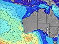 | 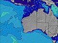 | 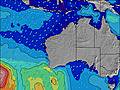 | 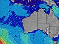 | ||||||||||||||
Wave Height (m) Direction Period (s) | SW 14 | SW 15 | SW 16 | SW 19 | SW 18 | SW 17 | SW 16 | SW 16 | SW 16 | SW 16 | SW 16 | SW 16 | SW 16 | SW 15 | SW 15 | SW 15 | SW 16 | SW 16 | SW 16 | SW 16 | SW 15 |
Wave Graph | |||||||||||||||||||||
1006 | 767 | 710 | 925 | 3056 | 3016 | 2003 | 3304 | 4076 | 3964 | 3482 | 2580 | 2354 | 2350 | 3185 | 2868 | 5200 | 5622 | 4694 | 3664 | 2553 | |
Wind (km/h) | |||||||||||||||||||||
Wind State on-shore cross-onshore cross-shore cross-offshore off-shore glassy | cross-off | cross | cross-off | cross-on | cross-on | cross | cross | cross-on | cross-off | cross-on | cross-on | cross-on | cross-on | cross-on | on | cross-on | cross-on | cross-off | cross-off | cross-on | cross-off |
High Tide | 11:07AM0.49m | 1:39AM0.51m | 11:02AM0.41m | 2:07AM0.56m | 2:44AM0.61m | 3:35AM0.65m | 4:40AM0.69m | 5:53AM0.73m | |||||||||||||
Low Tide | 6:01PM0.18m | 6:48AM0.36m | 6:02PM0.20m | 5:52PM0.21m | 4:32PM0.19m | 2:48PM0.10m | 3:18PM0.03m | 3:55PM-0.02m | |||||||||||||
7:03 | — | — | 7:03 | — | — | 7:01 | — | — | 7:01 | — | — | 7:01 | — | — | 7:00 | — | — | 6:58 | — | — | |
— | 5:50 | — | — | 5:51 | — | — | 5:52 | — | — | 5:52 | — | — | 5:52 | — | — | 5:52 | — | — | 5:53 | — | |
mm | — | — | 1 | 1 | — | — | — | — | — | — | — | — | — | — | 3 | — | — | — | — | — | — |
Temp °C | 19 | 20 | 19 | 18 | 18 | 17 | 15 | 16 | 17 | 16 | 17 | 17 | 18 | 19 | 18 | 17 | 16 | 15 | 13 | 16 | 16 |
Feels °C | 16 | 15 | 18 | 18 | 17 | 14 | 11 | 12 | 13 | 15 | 15 | 14 | 15 | 16 | 15 | 10 | 11 | 10 | 8 | 12 | 11 |
Swell 1 Height (m) Direction Period (s) | SW 14 | SW 15 | SW 16 | SW 15 | SW 18 | SW 17 | SW 16 | SW 16 | SW 16 | SW 16 | SW 16 | SW 16 | SW 16 | SW 15 | — | SW 15 | SW 16 | SW 16 | SW 16 | SW 16 | SW 15 |
1006 | 767 | 710 | 657 | 3056 | 3016 | 2003 | 3304 | 4076 | 3964 | 3482 | 2580 | 2354 | 2350 | — | 2868 | 5200 | 5622 | 4694 | 3664 | 2553 | |
Swell 2 Height (m) Direction Period (s) | — | — | W 4 | SW 19 | — | — | — | — | — | — | — | — | — | — | — | — | — | — | SW 24 | SW 22 | SW 20 |
— | — | 10 | 925 | — | — | — | — | — | — | — | — | — | — | — | — | — | — | 87 | 453 | 412 | |
Swell 3 Height (m) Direction Period (s) | — | — | SW 22 | SW 6 | — | — | — | — | — | — | — | — | — | — | — | — | — | — | — | — | — |
— | — | 118 | 39 | — | — | — | — | — | — | — | — | — | — | — | — | — | — | — | — | — | |
Wind waves Height (m) Direction Period (s) | — | — | — | — | — | — | — | — | — | — | — | — | — | — | SW 15 | — | — | — | — | — | — |
— | — | — | — | — | — | — | — | — | — | — | — | — | — | 3185 | — | — | — | — | — | — | |
Nearest Offshore or Glassy | |||||||||||||||||||||
Distance (km) | 0 | 597 | 0 | 347 | 726 | 6 | 6 | 507 | 0 | 6 | 705 | 38 | 347 | 592 | 2181 | 489 | 489 | 24 | 24 | 38 | 0 |
Best forecast wave conditions in North West WA | |||||||||||||||||||||
Best forecast wave conditions in Australia | |||||||||||||||||||||
Header Global | |||||||||||||||||||||
- Map Icons:
 Break
Break Live Wave Height (m)
 Live Wind Speed (km/h)
 Surf Rating (10 Max)
 Ocean Swells (m)
- Wind Speed (km/h)
Latest Updates


FREE! Surf-Forecast.com widget for your website
The surf report / weather widget below is available to embed on third party websites free of charge and provides a summary of our Greenough surf forecast. Simply grab the html code snippet that we provide and paste it into your own site. You can choose your preferred language and metric/imperial units for the surf forecast feed to suit users of your site. Click here to get the code.
Information about the Greenough Surf forecast
The above surf forecast table for Greenough provides essential information for determining whether the surfing conditions will be good over the next 16 days. A general guide to surfing at Greenough can be found by selecting the local surf guide option on the grey menu. Our Greenough surf forecast is unique since it includes wave energy (power) that defines the real feel of the surf rather than just the height or the period. If you surf the same spot (Greenough) regularly then make a mental note of the wave energy from the surf forecast table each time you go. Very soon you may start to choose your surf days based on the wave energy alone combined with our forecast of favourable offshore wind conditions. Our star ratings will help here and of course you will also find the usual wave height and period predictions on our surf forecasts as well as a full break down of the swell components under our advanced users option (to reveal that, click the little Einstein character under the tide times).
Further information to help with frequently asked questions about our surf forecast for Greenough may be found under the help tab on the top menu and also by moving your mouse over the question marks on the surf forecast table itself. Please always bear in mind that the forecast is for near-shore open water and local factors at each surf break influence the actual breaking wave height, such as the beach / reef profile, water depths offshore and shelter.
 Nearest