

Surf Forecasts:

Gnaraloo surf forecast from 1 Aug 2026:
- Best quality surf: Sunday 2 Aug, 5AM (local time) - 4ft (1.2m), 15s period, WSW swell with offshore winds.
- Most powerful swell: Thursday 6 Aug, 5PM (local time) - 6.5ft (2.0m), 16s period, WSW swell with 2,119 kJ wave energy.
- Next surfable swell (1★+): Sunday 2 Aug, 5AM (local time) - 4ft (1.2m), 15s period with WSW swell.
Best Forecast Surf Conditions for Gnaraloo this week:
The surf forecast for Gnaraloo over the next 16 days: The first swell (rated 1 star or higher) is forecast to arrive on Sunday (Aug 02) at 5AM. The primary swell is predicted to be 1.2m and 15s period with a secondary swell of 0.3m and 5s. The wind is predicted to be offshore as the swell arrives.
The most powerful waves expected at Gnaraloo in the next 16 days are 2.0m 16s and forecast to arrive on Thursday (Aug 06) at 5PM. Winds are predicted to be cross-shore at the time the swell arrives. The largest open ocean swell (not directed at the beach) is 0.9m 4s period and expected on Thursday (Aug 06) at 11PM.
| Wave Type | Time (AWST) & Date | Wave Height & Period |
|---|---|---|
| Next good surf (1 star+) | 5AM (Sun 2nd Aug) | 4ft (1.2m) 15s |
| Best Surf | 5AM (Sun 2nd Aug) | 4ft (1.2m) 15s |
| Most Powerful | 5PM (Thu 6th Aug) | 6.5ft (2.0m) 16s |
Table - best surf conditions forecast for Gnaraloo over the next 16 days.
The Lowdown
G’day, Rusty here, and we’ve got a solid block of swell on the cards for Gnaraloo over the next couple of weeks. It’s a reef set-up that’s consistent and exposed to the SW, so when the energy lines up, it can be a proper show. Let’s not waste time – we’re straight into it.
The water temp is sitting at 73°F, which is about average for this time of year, so no surprises there.
We kick off Saturday the 1st of August with a solid pulse. Morning sees a 5ft swell from the WSW, with a 16-second period pushing a combined energy of 1115 (moderate wave energy). The wind is offshore from the SE at 16 mph, which is a major plus – that’s clean, lined-up reef surf for experienced crew. The afternoon turns a bit cross-off and drops to 5ft, still clean but the score drops off. The best bet is definitely the morning session.
Sunday the 2nd stays in the zone with 4ft from the WSW, 15-second period, and a light ENE cross-off in the morning. Combined energy is 716 (moderate). Clean, fun waves, but not the standout. The afternoon gets a cross-on breeze and gets choppy – not worth it.
Monday the 3rd and Tuesday the 4th are a bit of a mixed bag. Monday is a write-off with strong cross-on winds and rain showers. Tuesday morning does offer a brief window with a 3ft swell, 16-second period, and a light SSE cross-off, giving clean conditions but the size is small. Combined energy is 550 (moderate). It’s a maybe, but not a priority.
Now, the first real standout is Wednesday the 5th. The morning has a 6ft WSW swell at 16 seconds, combined energy hitting 1540 (strong wave energy). The wind is a cross-off from the SSE at 16 mph, keeping it clean. That’s excellent surf for experienced surfers. Even the afternoon holds 5ft, but the wind freshens to 22 mph. The morning is the pick.
The swell builds through the week. Thursday the 6th morning is 7ft, 16 seconds, and combined energy of 2043 (strong). The SSW cross-off at 12 mph keeps it clean. That’s powerful, well-shaped reef surf for confident surfers. The afternoon picks up a cross-shore wind and gets lumpy, so stick to the morning.
Friday the 7th and Saturday the 8th are solid but not the best – 5ft to 7ft, clean mornings, but the winds are moderate to fresh. Worth a paddle if you’re keen, but the real highlight is Sunday the 9th.
Sunday the 9th is the absolute standout of the entire outlook. The morning has a 10ft WSW swell at 17 seconds, combined energy of 4653 (very strong wave energy). The wind is offshore from the SE at 19 mph – that’s a dream scenario for the reef. The afternoon is even better: 10ft, 19-second period, combined energy of 6659 (very strong), and a moderate offshore from the SSE at 16 mph. That’s exceptional surf for expert surfers only. This is the one to circle on the calendar.
Monday the 10th and Tuesday the 11th see the swell drop back. Monday is 7ft in the morning, clean, but the wind is a cross-off and the energy is still strong (2482). Tuesday drops to 4ft, with offshore winds, but the energy is much lower. Both are okay, but not special.
Wednesday the 12th has a nice 4ft swell with a 17-second period, clean offshore from the ESE, and combined energy of 903 (moderate). That’s a good, clean long-period swell, which suits the reef perfectly. The afternoon turns cross-shore, so morning is the go.
Thursday the 13th and Friday the 14th are a mixed bag. Thursday is a washout with onshore winds. Friday the 14th morning has a clean 5ft swell from the WSW at 17 seconds, combined energy of 1252 (strong), with a light S cross-off. That’s excellent surf for experienced surfers again.
The second week: Saturday the 15th holds a clean 4ft morning with offshore SSE breeze, and Sunday the 16th brings a bigger pulse – 8ft in the morning, 18 seconds, combined energy of 3717 (very strong), with a moderate offshore. That’s expert-only territory, but it’s a promising end to the outlook.
Overall, the standout is Sunday the 9th of August – that morning and afternoon session is the best on offer. The next best is Wednesday the 5th and Friday the 14th mornings. For the rest, pick the clean morning windows. The reef will be working, but the bigger days are for the experts only.
Rusty.
Short Range ForecastLight rain (total 7mm), mostly falling on Sun night. Warm (max 25°C on Sat afternoon, min 16°C on Sat morning). Winds decreasing (fresh winds from the S on Sat night, light winds from the E by Mon night). | Days 4-6 Weather SummaryMostly dry. Warm (max 23°C on Wed afternoon, min 17°C on Tue night). Winds increasing (light winds from the SSE on Tue morning, fresh winds from the SSW by Wed afternoon). | ||||||||||||||||||||
Saturday 1 | Sunday 2 | Monday 3 | Tuesday 4 | Wednesday 5 | Thursday 6 | Friday 7 | |||||||||||||||
AM | PM | Night | AM | PM | Night | AM | PM | Night | AM | PM | Night | AM | PM | Night | AM | PM | Night | AM | PM | Night | |
Swell Height Map |  |  |  | 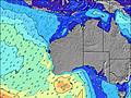 | 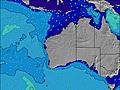 | 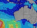 | 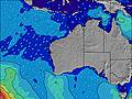 | ||||||||||||||
Wave Height (m) Direction Period (s) | WSW 16 | WSW 16 | WSW 15 | WSW 15 | WSW 15 | WSW 14 | WSW 13 | WSW 13 | WSW 15 | WSW 16 | WSW 19 | WSW 18 | WSW 16 | WSW 16 | WSW 17 | WSW 16 | WSW 16 | WSW 16 | WSW 16 | WSW 16 | WSW 15 |
Wave Graph | |||||||||||||||||||||
1109 | 938 | 573 | 716 | 706 | 529 | 434 | 373 | 485 | 469 | 949 | 1501 | 1540 | 1184 | 1668 | 2043 | 2119 | 1853 | 1239 | 1096 | 1323 | |
Wind (km/h) | |||||||||||||||||||||
Wind State on-shore cross-onshore cross-shore cross-offshore off-shore glassy | off | cross-off | off | cross-off | cross-on | cross | cross-on | cross | cross-on | cross-off | cross-off | cross-off | cross-off | cross-off | cross-off | cross-off | cross | cross-off | cross-off | cross | cross-off |
High Tide | 11:25AM1.13m | 00:30AM1.01m | 12:00PM1.09m | 00:53AM1.08m | 12:37PM1.02m | 1:17AM1.13m | 1:14PM0.94m | 1:44AM1.17m | 1:56PM0.83m | 2:15AM1.20m | 2:45PM0.72m | 2:54AM1.21m | 3:52PM0.61m | 3:43AM1.20m | |||||||
Low Tide | 6:01PM0.15m | 6:01AM0.43m | 6:22PM0.18m | 6:41AM0.39m | 6:42PM0.23m | 7:22AM0.36m | 7:02PM0.28m | 8:07AM0.33m | 7:24PM0.33m | 9:01AM0.32m | 7:45PM0.39m | 10:12AM0.33m | 8:05PM0.45m | ||||||||
7:01 | — | — | 7:01 | — | — | 7:00 | — | — | 6:58 | — | — | 6:58 | — | — | 6:58 | — | — | 6:58 | — | — | |
— | 6:01 | — | — | 6:02 | — | — | 6:02 | — | — | 6:04 | — | — | 6:04 | — | — | 6:05 | — | — | 6:05 | — | |
mm | — | — | — | — | — | 2 | 1 | 2 | 2 | — | — | — | — | — | — | — | — | — | — | — | — |
Temp °C | 21 | 25 | 21 | 23 | 23 | 22 | 21 | 21 | 20 | 22 | 22 | 21 | 20 | 23 | 19 | 20 | 20 | 19 | 19 | 20 | 20 |
Feels °C | 15 | 20 | 14 | 18 | 19 | 20 | 19 | 18 | 18 | 23 | 21 | 18 | 16 | 19 | 14 | 18 | 16 | 15 | 16 | 16 | 16 |
Swell 1 Height (m) Direction Period (s) | WSW 16 | WSW 16 | WSW 15 | WSW 15 | WSW 15 | WSW 14 | WSW 13 | WSW 13 | WSW 15 | WSW 16 | WSW 19 | WSW 18 | WSW 16 | WSW 16 | WSW 17 | WSW 16 | WSW 16 | WSW 16 | WSW 16 | WSW 16 | WSW 15 |
1109 | 938 | 573 | 716 | 706 | 529 | 434 | 373 | 485 | 469 | 949 | 1501 | 1540 | 1184 | 1668 | 2043 | 2119 | 1853 | 1239 | 1096 | 1323 | |
Swell 2 Height (m) Direction Period (s) | NW 12 | — | SW 5 | — | — | — | W 17 | W 17 | N 5 | N 7 | N 6 | — | — | — | — | — | — | — | NW 12 | WNW 12 | WNW 11 |
6 | — | 6 | — | — | — | 153 | 93 | 27 | 14 | 7 | — | — | — | — | — | — | — | 6 | 14 | 12 | |
Swell 3 Height (m) Direction Period (s) | — | — | — | — | — | — | — | — | — | W 21 | — | — | — | — | — | — | — | — | — | — | — |
— | — | — | — | — | — | — | — | — | 81 | — | — | — | — | — | — | — | — | — | — | — | |
Wind waves Height (m) Direction Period (s) | SSE 3 | — | SSE 3 | — | — | NNE 4 | N 6 | N 6 | — | — | SSW 2 | — | SE 3 | — | — | — | — | SW 4 | — | — | — |
5 | — | 7 | — | — | 15 | 44 | 39 | — | — | 1 | — | 1 | — | — | — | — | 11 | — | — | — | |
Nearest Offshore or Glassy | |||||||||||||||||||||
Distance (km) | 0 | 1081 | 216 | 0 | 543 | 267 | 1177 | 1186 | 216 | 0 | 227 | 216 | 216 | 577 | 446 | 216 | 1294 | 1300 | 1689 | 1671 | 1669 |
Best forecast wave conditions in North West WA | |||||||||||||||||||||
Best forecast wave conditions in Australia | |||||||||||||||||||||
Header Global | |||||||||||||||||||||
- Map Icons:
 Break
Break Live Wave Height (m)
 Live Wind Speed (km/h)
 Surf Rating (10 Max)
 Ocean Swells (m)
- Wind Speed (km/h)
Latest Updates


FREE! Surf-Forecast.com widget for your website
The surf report / weather widget below is available to embed on third party websites free of charge and provides a summary of our Gnaraloo surf forecast. Simply grab the html code snippet that we provide and paste it into your own site. You can choose your preferred language and metric/imperial units for the surf forecast feed to suit users of your site. Click here to get the code.
Information about the Gnaraloo Surf forecast
The above surf forecast table for Gnaraloo provides essential information for determining whether the surfing conditions will be good over the next 16 days. A general guide to surfing at Gnaraloo can be found by selecting the local surf guide option on the grey menu. Our Gnaraloo surf forecast is unique since it includes wave energy (power) that defines the real feel of the surf rather than just the height or the period. If you surf the same spot (Gnaraloo) regularly then make a mental note of the wave energy from the surf forecast table each time you go. Very soon you may start to choose your surf days based on the wave energy alone combined with our forecast of favourable offshore wind conditions. Our star ratings will help here and of course you will also find the usual wave height and period predictions on our surf forecasts as well as a full break down of the swell components under our advanced users option (to reveal that, click the little Einstein character under the tide times).
Further information to help with frequently asked questions about our surf forecast for Gnaraloo may be found under the help tab on the top menu and also by moving your mouse over the question marks on the surf forecast table itself. Please always bear in mind that the forecast is for near-shore open water and local factors at each surf break influence the actual breaking wave height, such as the beach / reef profile, water depths offshore and shelter.
Are you planning a holiday in North West WA? If you are looking for accommodation near Gnaraloo, camping, hotels and holiday cottages in North West WA, consider staying in Cape Cuvier which is 55 km (34 miles) away.
 Nearest