

Surf Forecasts:

Desert Point surf forecast from 2 Aug 2026:
- Best quality surf: Friday 7 Aug, 10AM (local time) - 5.5ft (1.7m), 8s period, NNW swell with glassy winds.
- Most powerful swell: Wednesday 5 Aug, 10PM (local time) - 7ft (2.2m), 8s period, NNW swell with 597 kJ wave energy.
- Next surfable swell (1★+): Tuesday 4 Aug, 7AM (local time) - 5ft (1.5m), 7s period with NNW swell.
Best Forecast Surf Conditions for Desert Point this week:
The surf forecast for Desert Point over the next 16 days: The first swell (rated 1 star or higher) is forecast to arrive on Tuesday (Aug 04) at 7AM. The primary swell is predicted to be 1.5m and 7s period with a secondary swell of 0.4m and 9s. The wind is predicted to be glassy as the swell arrives.
The most powerful waves expected at Desert Point in the next 16 days are 2.2m 8s and forecast to arrive on Wednesday (Aug 05) at 10PM. Winds are predicted to be cross-onshore at the time the swell arrives.
| Wave Type | Time (+01) & Date | Wave Height & Period |
|---|---|---|
| Next good surf (1 star+) | 7AM (Tue 4th Aug) | 5ft (1.5m) 7s |
| Best Surf | 10AM (Fri 7th Aug) | 5.5ft (1.7m) 8s |
| Most Powerful | 10PM (Wed 5th Aug) | 7ft (2.2m) 8s |
Table - best surf conditions forecast for Desert Point over the next 16 days.
The Lowdown
Alright, Rusty here again. Let’s talk about this stretch.
Starting quiet. Sunday morning the 2nd gives you a tiny 4ft NW windswell with a real short 7-second period. The water’s a balmy 70°, which is dead average for the time of year. The wind is glassy, light from the NNW, so the surface is perfect, but the waves are just ordinary – weak energy (175) and not much to ride. Barely worth wetting the suit.
Monday the 3rd and Tuesday the 4th are a mess of cross-onshore and onshore wind, though Tuesday morning gets glassy again with 5ft of NW swell and a 7-second period. The energy is moderate (250), and the waves are surfable but ordinary. It’s a brief clean window – by afternoon the wind ruins it.
Things start to look up from Wednesday the 5th. The swell builds, and by Friday the 7th morning we’ve got a real winner. The wind is dead calm and glassy, with a solid 6ft of NW swell and an 8-second period. The energy hits a solid moderate 437. This will be clean, chest-shoulder high waves for the intermediate surfer – the best of the first week.
Saturday the 8th morning is another glassy one, same 6ft NW swell, moderate energy (381). Another shot at clean waves before the afternoons turn onshore.
Into the second week, it gets rougher. The swell stays around 5ft to 6ft, but the winds are mostly onshore. The best bet there is Tuesday the 11th morning – 6ft NW swell with a light onshore, marginal but still pushy with energy at 428. You’ll have some wind bump.
After that, it fades fast. By Saturday the 15th we’re down to 4ft, and the following days drop to tiny 2ft windswell. Energy goes below 200, and the winds are onshore. That’s the end of the run.
The standout session is Friday the 7th morning – that glassy, 6ft NW swell will make Desert Point clean and fun. Saturday the 8th morning is a close second. Crowd levels are possible there, so get out early. The spot is wide open to the NW, and that’s exactly where the swell is coming from.
Not a classic forecast, but there’s a couple of solid windows for anyone keen.
Rusty.
Short Range ForecastMostly dry. Warm (max 31°C on Sun morning, min 20°C on Tue night). Wind will be generally light. | Days 4-6 Weather SummaryMostly dry. Warm (max 24°C on Wed morning, min 20°C on Wed night). Wind will be generally light. | ||||||||||||||||||||
Sunday 2 | Monday 3 | Tuesday 4 | Wednesday 5 | Thursday 6 | Friday 7 | Saturday 8 | |||||||||||||||
AM | PM | Night | AM | PM | Night | AM | PM | Night | AM | PM | Night | AM | PM | Night | AM | PM | Night | AM | PM | Night | |
Swell Height Map | 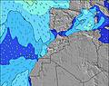 | 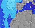 | 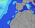 | 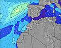 | 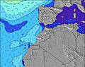 | 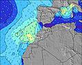 | 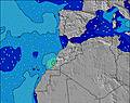 | ||||||||||||||
Wave Height (m) Direction Period (s) | NNW 7 | NNW 7 | NNW 7 | NNW 7 | NNW 7 | NNW 7 | NNW 7 | NNW 7 | NNW 8 | NNW 8 | NNW 8 | NNW 8 | NNW 8 | NNW 7 | NNW 8 | NNW 8 | NNW 8 | NNW 8 | NNW 8 | NNW 8 | NNW 8 |
Wave Graph | |||||||||||||||||||||
121 | 121 | 247 | 181 | 149 | 302 | 242 | 236 | 411 | 336 | 336 | 597 | 403 | 237 | 480 | 402 | 336 | 418 | 366 | 291 | 463 | |
Wind (km/h) | |||||||||||||||||||||
Wind State on-shore cross-onshore cross-shore cross-offshore off-shore glassy | glassy | on | cross-on | cross-on | cross-on | cross-on | glassy | on | cross-on | cross-on | on | cross-on | cross-on | on | cross-on | glassy | on | cross-on | glassy | on | cross-on |
High Tide | 4:58PM2.68m | 5:20AM2.45m | 5:34PM2.59m | 6:00AM2.37m | 6:16PM2.45m | 6:46AM2.27m | 7:08PM2.29m | 7:45AM2.17m | 8:17PM2.15m | 9:02AM2.11m | 9:45PM2.09m | 10:28AM2.17m | 11:12PM2.16m | ||||||||
Low Tide | 10:40AM0.34m | 11:09PM0.29m | 11:16AM0.41m | 11:45PM0.37m | 11:57AM0.50m | 00:28AM0.49m | 12:47PM0.62m | 1:21AM0.62m | 1:51PM0.74m | 2:31AM0.75m | 3:17PM0.79m | 3:59AM0.78m | 4:50PM0.70m | ||||||||
6:58 | — | — | 6:58 | — | — | 7:00 | — | — | 7:00 | — | — | 7:01 | — | — | 7:01 | — | — | 7:01 | — | — | |
— | 8:31 | — | — | 8:30 | — | — | 8:30 | — | — | 8:29 | — | — | 8:28 | — | — | 8:28 | — | — | 8:27 | — | |
mm | — | — | — | — | — | — | — | — | — | — | — | — | — | — | — | — | — | — | — | — | — |
Temp °C | 31 | 30 | 26 | 27 | 26 | 24 | 27 | 25 | 23 | 24 | 23 | 21 | 24 | 23 | 22 | 23 | 23 | 20 | 24 | 22 | 20 |
Feels °C | 31 | 30 | 25 | 27 | 26 | 23 | 27 | 25 | 23 | 24 | 23 | 21 | 24 | 23 | 22 | 26 | 24 | 21 | 24 | 22 | 21 |
Swell 1 Height (m) Direction Period (s) | NNW 7 | NNW 7 | NNW 7 | NNW 7 | NNW 7 | NNW 7 | NNW 7 | NNW 7 | NNW 8 | NNW 8 | NNW 8 | NNW 8 | NNW 8 | NNW 7 | NNW 8 | NNW 8 | NNW 8 | NNW 8 | NNW 8 | NNW 8 | NNW 8 |
121 | 121 | 247 | 181 | 149 | 302 | 242 | 236 | 411 | 336 | 336 | 597 | 403 | 237 | 480 | 402 | 336 | 418 | 366 | 291 | 463 | |
Swell 2 Height (m) Direction Period (s) | WNW 9 | WNW 9 | WNW 8 | WNW 10 | WNW 9 | WNW 8 | WNW 9 | — | — | — | WNW 10 | — | WNW 10 | NNW 9 | WNW 9 | WNW 9 | WNW 9 | NW 9 | WNW 9 | WNW 9 | WNW 9 |
52 | 52 | 41 | 36 | 34 | 28 | 8 | — | — | — | 10 | — | 35 | 130 | 32 | 35 | 33 | 21 | 15 | 15 | 15 | |
Swell 3 Height (m) Direction Period (s) | N 11 | — | — | — | — | — | — | — | — | — | NW 13 | — | — | WNW 10 | — | — | — | — | — | — | — |
2 | — | — | — | — | — | — | — | — | — | 7 | — | — | 37 | — | — | — | — | — | — | — | |
Wind waves Height (m) Direction Period (s) | — | — | — | — | — | — | — | — | — | — | — | — | — | — | — | — | — | — | — | — | — |
— | — | — | — | — | — | — | — | — | — | — | — | — | — | — | — | — | — | — | — | — | |
Nearest Offshore or Glassy | |||||||||||||||||||||
Distance (km) | 0 | 398 | 73 | 46 | 398 | 42 | 0 | 398 | 46 | 46 | 627 | 46 | 46 | 84 | 46 | 0 | 80 | 46 | 0 | 627 | 46 |
Best forecast wave conditions in Southern Morocco | |||||||||||||||||||||
Best forecast wave conditions in Morocco | |||||||||||||||||||||
Header Global | |||||||||||||||||||||
- Map Icons:
 Break
Break Live Wave Height (m)
 Live Wind Speed (km/h)
 Surf Rating (10 Max)
 Ocean Swells (m)
- Wind Speed (km/h)
Latest Updates


FREE! Surf-Forecast.com widget for your website
The surf report / weather widget below is available to embed on third party websites free of charge and provides a summary of our Desert Point surf forecast. Simply grab the html code snippet that we provide and paste it into your own site. You can choose your preferred language and metric/imperial units for the surf forecast feed to suit users of your site. Click here to get the code.
Information about the Desert Point Surf forecast
The above surf forecast table for Desert Point provides essential information for determining whether the surfing conditions will be good over the next 16 days. A general guide to surfing at Desert Point can be found by selecting the local surf guide option on the grey menu. Our Desert Point surf forecast is unique since it includes wave energy (power) that defines the real feel of the surf rather than just the height or the period. If you surf the same spot (Desert Point) regularly then make a mental note of the wave energy from the surf forecast table each time you go. Very soon you may start to choose your surf days based on the wave energy alone combined with our forecast of favourable offshore wind conditions. Our star ratings will help here and of course you will also find the usual wave height and period predictions on our surf forecasts as well as a full break down of the swell components under our advanced users option (to reveal that, click the little Einstein character under the tide times).
Further information to help with frequently asked questions about our surf forecast for Desert Point may be found under the help tab on the top menu and also by moving your mouse over the question marks on the surf forecast table itself. Please always bear in mind that the forecast is for near-shore open water and local factors at each surf break influence the actual breaking wave height, such as the beach / reef profile, water depths offshore and shelter.
Desert Point is 17 km (11 miles) from Tiznit. If you plan a holiday in Southern Morocco, look for hotels and other accommodation in Tiznit. Tiznit has rooms for a wide range of budgets as well as car hire and transport links.
 Nearest