

Surf Forecasts:

Cacas Point surf forecast from 31 Jul 2026:
- Best quality surf: Friday 7 Aug, 6AM (local time) - 2.5ft (0.8m), 18s period, SSW swell with offshore winds.
- Most powerful swell: Friday 31 Jul, 6AM (local time) - 4ft (1.2m), 14s period, SSW swell with 522 kJ wave energy.
- Next surfable swell (1★+): Friday 31 Jul, 6AM (local time) - 4ft (1.2m), 14s period with SSW swell.
Best Forecast Surf Conditions for Cacas Point this week:
The surf forecast for Cacas Point over the next 16 days: The first swell (rated 1 star or higher) is forecast to arrive on Friday (Jul 31) at 6AM. The primary swell is predicted to be 1.2m and 14s period with a secondary swell of 0.6m and 11s. The wind is predicted to be offshore as the swell arrives.
The most powerful waves expected at Cacas Point in the next 16 days are 1.2m 14s and forecast to arrive on Friday (Jul 31) at 6AM. Winds are predicted to be offshore at the time the swell arrives. The largest open ocean swell (not directed at the beach) is 0.8m 5s period and expected on Sunday (Aug 02) at 3AM.
| Wave Type | Time (CST) & Date | Wave Height & Period |
|---|---|---|
| Next good surf (1 star+) | 6AM (Fri 31st Jul) | 4ft (1.2m) 14s |
| Best Surf | 6AM (Fri 7th Aug) | 2.5ft (0.8m) 18s |
| Most Powerful | 6AM (Fri 31st Jul) | 4ft (1.2m) 14s |
Table - best surf conditions forecast for Cacas Point over the next 16 days.
The Lowdown
Right, let’s have a look at the next couple of weeks for Cacas Point. It’s a bit of a mixed bag, but there are definitely some windows where it’s going to be worth the paddle out. This spot is a point break, and it’s inconsistent, so you gotta pick your moments. The water temp is sitting right around average for this time of year, so nothing wild there.
We’ve got a run of surf starting right away. Friday morning, the 31st, looks clean with a cross-off breeze and some nice 4ft SSW swell pushing through with a 13-second period. The combined energy is sitting at 597, which is moderate. It’s not huge, but it’s clean and shapely. That afternoon the wind swings around to the west and gets up to 12 mph, making a mess of things. So it’s very much a morning session.
Saturday the 1st is a similar script. Morning brings 3ft SSW swell, clean conditions, and that moderate energy of 428. Again, the afternoon is blown out by that westerly. Sunday the 2nd drops off a bit to 2ft, but the morning is glassy with an ENE breeze. It’s small, and honestly, pretty ordinary. The energy is weak at 255. It’s surfable, but don’t expect much.
Monday the 3rd is worth a look. We get a slight bump in period to 14 seconds with 3ft SSW swell. Combined energy is 360, still moderate, but the conditions are clean with a cross-off breeze. There’s a risk of thunderstorms, but you know, that’s the tropics for you.
Tuesday the 4th and Wednesday the 5th are pretty lackluster. Small, weak swells in the 2ft to 2ft range. Wednesday morning is poor surf conditions with light cross-shore winds. I’d probably give those days a miss.
Thursday the 6th shows a little life again. Glassy morning, 2ft SW swell, with a period of 13 seconds. Energy is 322, weak but clean. The afternoon gets messy with a longer period 18-second swell but onshore winds. Friday the 7th is where things start to get interesting. The morning is glassy with 3ft SSW groundswell and a long 18-second period. The energy jumps to 705, which is moderate. That's a proper cleanup set. This is a standout morning. This long period is definitely better for this point setup than a beach break.
Saturday the 8th follows up nicely. Morning has a cross-off breeze, 4ft SSW swell with a 16-second period, and energy building to 773. That's another excellent session. The afternoon is questionable with cross-shore winds and a drop in quality. So, the 7th and 8th are mornings to circle on the calendar.
The second week gets a bit more repetitive. The mornings from the 9th through the 14th are all looking glassy with clean conditions. Swells hover around the 3ft to 4ft range, mostly from the SSW or SW, with periods ranging from 13 to 17 seconds. Energy is consistently moderate, from the mid-400s up to 799 on the 12th. Every morning is a good call, but the afternoons all turn onshore or cross-shore. Just get out there early.
The standout of the whole period, though, is likely Saturday the 15th. The morning is glassy, and we have 4ft SW swell with a 16-second period. The combined energy is the highest of the run at 939, which is knocking on the door of strong. This looks like the best of the bunch for clean, solid point surf.
So, overall, it’s a pattern of clean mornings and blown-out afternoons. You’ll want to be an early bird. The best bets are the mornings of the 7th and the 15th, with the 8th and 12th also offering up great potential. Those long-period swells will be well-defined at this point. The inconsistent nature means you don't have endless options, but when it's on, it's on. This is a promising outlook, especially for a point break in a semi-exposed spot.
Rusty.
Short Range ForecastModerate rain (total 11mm), heaviest on Sat night. Warm (max 31°C on Fri afternoon, min 26°C on Thu night). Wind will be generally light. | Days 5-7 Weather SummaryHeavy rain (total 23mm), heaviest during Tue night. Warm (max 30°C on Mon morning, min 26°C on Tue night). Wind will be generally light. | ||||||||||||||||||
Friday 31 | Saturday 1 | Sunday 2 | Monday 3 | Tuesday 4 | Wednesday 5 | ||||||||||||||
Night | AM | PM | Night | AM | PM | Night | AM | PM | Night | AM | PM | Night | AM | PM | Night | AM | PM | Night | |
Swell Height Map |  |  |  |  | 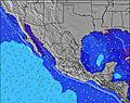 | 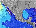 | 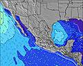 | ||||||||||||
Wave Height (m) Direction Period (s) | SSW 14 | SSW 13 | SSW 13 | SSW 13 | SSW 13 | SSW 13 | SSW 12 | SW 14 | SW 14 | SSW 14 | SSW 14 | SW 12 | SSW 13 | SSW 12 | SSW 12 | SSW 12 | SW 15 | SW 14 | SW 14 |
Wave Graph | |||||||||||||||||||
692 | 506 | 451 | 346 | 312 | 249 | 161 | 123 | 145 | 236 | 265 | 159 | 114 | 103 | 98 | 96 | 134 | 102 | 127 | |
Wind (km/h) | |||||||||||||||||||
Wind State on-shore cross-onshore cross-shore cross-offshore off-shore glassy | off | cross-off | cross | cross-off | cross-off | cross | cross | glassy | cross | cross-off | cross-off | cross-on | glassy | cross-off | on | cross-off | cross | on | cross-off |
High Tide | 4:27PM0.57m | 4:51AM0.41m | 5:02PM0.55m | 6:17AM0.50m | 5:34PM0.55m | 7:04AM0.60m | 6:07PM0.56m | 7:40AM0.68m | 6:43PM0.56m | 8:11AM0.74m | 7:19PM0.56m | ||||||||
Low Tide | 8:20AM0.26m | 11:55PM0.34m | 10:12AM0.31m | 11:49PM0.28m | 11:43AM0.34m | 00:08AM0.22m | 12:49PM0.35m | 00:36AM0.16m | 1:38PM0.35m | 1:06AM0.11m | 2:19PM0.33m | 1:37AM0.07m | |||||||
— | 6:18 | — | — | 6:18 | — | — | 6:18 | — | — | 6:20 | — | — | 6:20 | — | — | 6:20 | — | — | |
— | — | 7:12 | — | — | 7:12 | — | — | 7:10 | — | — | 7:10 | — | — | 7:09 | — | — | 7:09 | — | |
mm | 1 | — | — | 1 | — | — | 9 | — | — | 7 | 1 | 1 | 7 | — | — | 7 | — | — | 3 |
Temp °C | 29 | 30 | 31 | 29 | 30 | 31 | 29 | 30 | 30 | 29 | 30 | 30 | 29 | 30 | 30 | 29 | 30 | 30 | 28 |
Feels °C | 33 | 32 | 32 | 32 | 32 | 33 | 32 | 34 | 33 | 33 | 34 | 35 | 35 | 33 | 32 | 35 | 32 | 33 | 33 |
Swell 1 Height (m) Direction Period (s) | SSW 14 | SSW 13 | SSW 13 | SSW 13 | SSW 13 | SSW 13 | SSW 12 | SSW 12 | SSW 12 | SSW 14 | SSW 14 | SW 12 | SSW 13 | SSW 12 | S 8 | S 8 | S 9 | S 9 | S 8 |
692 | 506 | 451 | 346 | 312 | 249 | 161 | 123 | 145 | 236 | 265 | 159 | 114 | 103 | 47 | 66 | 76 | 55 | 51 | |
Swell 2 Height (m) Direction Period (s) | W 11 | W 11 | W 10 | W 10 | W 9 | SW 15 | SW 15 | SW 14 | SW 14 | W 5 | W 5 | W 6 | S 9 | S 8 | SSW 12 | SSW 12 | SW 15 | SW 14 | SW 14 |
79 | 79 | 76 | 30 | 27 | 109 | 134 | 121 | 114 | 18 | 13 | 15 | 55 | 29 | 98 | 96 | 134 | 102 | 127 | |
Swell 3 Height (m) Direction Period (s) | SSE 7 | SW 18 | S 8 | SW 16 | SW 16 | W 9 | W 9 | W 5 | SW 18 | SW 13 | SW 13 | S 9 | SW 12 | SW 16 | SW 15 | SW 15 | SSW 12 | SW 11 | SW 20 |
5 | 12 | 12 | 91 | 89 | 25 | 14 | 11 | 49 | 108 | 82 | 26 | 52 | 90 | 80 | 76 | 27 | 33 | 97 | |
Wind waves Height (m) Direction Period (s) | — | — | — | WNW 3 | WNW 3 | W 3 | W 4 | — | W 8 | — | — | — | — | — | WSW 8 | — | — | W 7 | — |
— | — | — | 3 | 2 | 5 | 20 | — | 49 | — | — | — | — | — | 12 | — | — | 3 | — | |
Nearest Offshore or Glassy | |||||||||||||||||||
Distance (km) | 0 | 0 | 488 | 0 | 0 | 505 | 61 | 0 | 734 | 0 | 0 | 710 | 0 | 0 | 730 | 0 | 4 | 499 | 0 |
Best forecast wave conditions in Guerrero | |||||||||||||||||||
Best forecast wave conditions in Mexico | |||||||||||||||||||
Header Global | |||||||||||||||||||
- Map Icons:
 Break
Break Live Wave Height (m)
 Live Wind Speed (km/h)
 Surf Rating (10 Max)
 Ocean Swells (m)
- Wind Speed (km/h)
Latest Updates


FREE! Surf-Forecast.com widget for your website
The surf report / weather widget below is available to embed on third party websites free of charge and provides a summary of our Cacas Point surf forecast. Simply grab the html code snippet that we provide and paste it into your own site. You can choose your preferred language and metric/imperial units for the surf forecast feed to suit users of your site. Click here to get the code.
Information about the Cacas Point Surf forecast
The above surf forecast table for Cacas Point provides essential information for determining whether the surfing conditions will be good over the next 16 days. A general guide to surfing at Cacas Point can be found by selecting the local surf guide option on the grey menu. Our Cacas Point surf forecast is unique since it includes wave energy (power) that defines the real feel of the surf rather than just the height or the period. If you surf the same spot (Cacas Point) regularly then make a mental note of the wave energy from the surf forecast table each time you go. Very soon you may start to choose your surf days based on the wave energy alone combined with our forecast of favourable offshore wind conditions. Our star ratings will help here and of course you will also find the usual wave height and period predictions on our surf forecasts as well as a full break down of the swell components under our advanced users option (to reveal that, click the little Einstein character under the tide times).
Further information to help with frequently asked questions about our surf forecast for Cacas Point may be found under the help tab on the top menu and also by moving your mouse over the question marks on the surf forecast table itself. Please always bear in mind that the forecast is for near-shore open water and local factors at each surf break influence the actual breaking wave height, such as the beach / reef profile, water depths offshore and shelter.
Are you planning a holiday in Guerrero? If you are looking for accommodation near Cacas Point, camping, hotels and holiday cottages in Guerrero, consider staying in Acapulco which is 2 km (1 miles) away. Other places in and around Guerrero where you can find information about places to rent, and car hire include Atoyac de Alvarez which is 70 km (43 miles) away, Cuatlas, Chilpancingo and Tixtla de Guerrero.
 Nearest