

Surf Forecasts:

Bahia surf forecast from 14 Jul 2026:
- Best quality surf: Sunday 19 Jul, 9AM (local time) - 3ft (0.9m), 12s period, WSW swell with cross-offshore winds.
- Most powerful swell: Sunday 19 Jul, 12AM (local time) - 3ft (0.9m), 13s period, WSW swell with 265 kJ wave energy.
- Next surfable swell (1★+): Tuesday 14 Jul, 12PM (local time) - 1.5ft (0.4m), 18s period with SW swell.
Best Forecast Surf Conditions for Bahia this week:
The surf forecast for Bahia over the next 16 days: The first swell (rated 1 star or higher) is forecast to arrive on Tuesday (Jul 14) at 12PM. The primary swell is predicted to be 0.4m and 18s period with a secondary swell of 0.4m and 13s. The wind is predicted to be glassy as the swell arrives.
The most powerful waves expected at Bahia in the next 16 days are 0.9m 13s and forecast to arrive on Sunday (Jul 19) at 12AM. Winds are predicted to be cross-onshore at the time the swell arrives. The largest open ocean swell (not directed at the beach) is 0.2m 2s period and expected on Wednesday (Jul 15) at 3PM.
| Wave Type | Time (CST) & Date | Wave Height & Period |
|---|---|---|
| Next good surf (1 star+) | 12PM (Tue 14th Jul) | 1.5ft (0.4m) 18s |
| Best Surf | 9AM (Sun 19th Jul) | 3ft (0.9m) 12s |
| Most Powerful | 12AM (Sun 19th Jul) | 3ft (0.9m) 13s |
Table - best surf conditions forecast for Bahia over the next 16 days.
The Lowdown
G’day, Rusty here.
Look, let’s be straight with you – the next couple of weeks at Bahia is a real mixed bag. We’ve got a reef break that’s very consistent, exposed to the swell, and loves a WNW direction. The water is sitting at 89°, which is much warmer than normal for this time of year – that’s a proper anomaly.
The first few days are pretty ordinary. Tuesday the 14th and Wednesday the 15th have tiny, weak swell (combined energy 122 and 85) – think knee-high or less, with periods that are long enough to be clean but zero power. It’s surfable but nothing to get excited about.
Thursday the 16th through to Friday the 17th are much the same story: small 1.0-1ft swells, light offshore winds in the mornings, but the energy is weak (around 117-122). You’ll get a few small, clean waves but that’s about it.
Now, Saturday the 18th morning is where things start to look up. We’ve got a 1ft SW swell with a 17-second period, combined energy jumping to 234 (moderate). The wind is dead calm – glassy conditions – and the forecast says “expect good surf conditions.” It’s small, but clean.
Sunday the 19th morning is the first real standout. The swell bumps to 2ft from the SW, period 17 seconds, and the combined energy rockets to 502 (strong). Winds are light and cross-offshore, keeping it clean. The forecast says “expect very good surf conditions.” This is your best bet for the first week – small but punchy, with that long period making for lined-up waves on the reef. Just be aware, crowds can be a factor here sometimes.
The following week, from Monday the 20th through to Thursday the 24th, we see a steady run of 2-3ft SW swells, with periods dropping to 12-16 seconds. The mornings are generally clean with light offshore winds. The energy sits in the moderate to strong range (241-426). Not epic, but a solid, surfable stretch.
Then, Saturday the 25th morning looks like another standout. The swell drops to 2ft but the period goes right up to 21 seconds – that’s very long-period groundswell. Combined energy is 507 (strong). Winds are light offshore, glassy, and the forecast says “expect very good surf conditions.” This is a long-range call, so it’s a little less certain, but if it comes in, it’ll be proper, clean, and lined up on the reef.
The end of the month, Tuesday the 29th morning, shows a 4ft SSW swell with a 14-second period and combined energy of 747 (very strong). Winds are light and cross-offshore, with “expect very good surf conditions.” That’s a solid size for the reef, and with clean conditions, it’ll be a good one for experienced surfers.
Overall, the best windows are Sunday the 19th morning, and the long-range promise of Saturday the 25th morning and Tuesday the 29th morning. The rest is small but clean in the mornings – worth a paddle if you’re keen.
Rusty.
Short Range ForecastLight rain (total 6mm), mostly falling on Tue night. Warm (max 30°C on Tue afternoon, min 27°C on Tue morning). Wind will be generally light. | Days 4-6 Weather SummaryModerate rain (total 10mm), heaviest on Sat afternoon. Warm (max 30°C on Fri afternoon, min 26°C on Sun night). Wind will be generally light. | ||||||||||||||||||||
Tuesday 14 | Wednesday 15 | Thursday 16 | Friday 17 | Saturday 18 | Sunday 19 | Monday 20 | |||||||||||||||
AM | PM | Night | AM | PM | Night | AM | PM | Night | AM | PM | Night | AM | PM | Night | AM | PM | Night | AM | PM | Night | |
Swell Height Map |  |  |  | 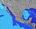 | 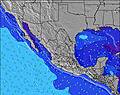 | 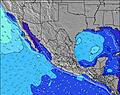 | 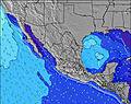 | ||||||||||||||
Wave Height (m) Direction Period (s) | SW 18 | SW 18 | SW 18 | WSW 18 | SW 16 | SW 16 | SW 16 | SW 16 | SW 15 | SW 15 | SW 14 | SW 17 | SW 17 | SW 13 | WSW 13 | WSW 12 | WSW 12 | WSW 11 | SW 16 | SW 16 | SW 15 |
Wave Graph | |||||||||||||||||||||
68 | 111 | 49 | 30 | 93 | 91 | 64 | 62 | 58 | 55 | 53 | 77 | 104 | 196 | 265 | 232 | 218 | 133 | 203 | 203 | 242 | |
Wind (km/h) | |||||||||||||||||||||
Wind State on-shore cross-onshore cross-shore cross-offshore off-shore glassy | off | cross-on | cross-off | off | cross-off | off | off | cross | cross-off | off | cross | cross-off | off | cross-on | cross-on | cross-off | cross-on | cross | cross-off | cross-off | cross-off |
High Tide | 10:31AM1.25m | 9:12PM1.62m | 11:05AM1.25m | 9:56PM1.55m | 11:38AM1.24m | 10:38PM1.44m | 12:09PM1.24m | 11:19PM1.30m | 12:40PM1.23m | 00:02AM1.13m | 1:10PM1.22m | 00:54AM0.97m | 1:44PM1.20m | 2:40AM0.83m | |||||||
Low Tide | 3:21PM0.77m | 4:23AM-0.04m | 4:03PM0.73m | 4:59AM0.07m | 4:47PM0.72m | 5:31AM0.21m | 5:32PM0.71m | 5:58AM0.37m | 6:23PM0.72m | 6:18AM0.53m | 7:28PM0.73m | 6:27AM0.67m | 9:21PM0.72m | ||||||||
6:28 | — | — | 6:28 | — | — | 6:30 | — | — | 6:30 | — | — | 6:30 | — | — | 6:31 | — | — | 6:31 | — | — | |
— | 7:45 | — | — | 7:45 | — | — | 7:45 | — | — | 7:45 | — | — | 7:45 | — | — | 7:45 | — | — | 7:45 | — | |
mm | — | — | 5 | — | — | — | — | — | 1 | — | — | — | — | 4 | 3 | 1 | 2 | — | — | — | — |
Temp °C | 29 | 30 | 29 | 29 | 30 | 29 | 29 | 30 | 29 | 29 | 30 | 28 | 29 | 29 | 28 | 28 | 29 | 29 | 29 | 29 | 29 |
Feels °C | 34 | 33 | 34 | 32 | 32 | 32 | 32 | 33 | 33 | 32 | 33 | 32 | 33 | 33 | 33 | 32 | 33 | 32 | 32 | 31 | 33 |
Swell 1 Height (m) Direction Period (s) | SSW 13 | SW 18 | SW 13 | SSW 12 | SW 16 | SW 16 | SW 16 | SW 16 | SW 15 | SW 15 | SW 11 | SW 11 | SW 10 | SW 13 | WSW 13 | WSW 12 | WSW 12 | WSW 11 | SW 16 | SW 16 | SW 15 |
68 | 111 | 40 | 29 | 93 | 91 | 64 | 62 | 54 | 54 | 30 | 29 | 47 | 196 | 265 | 211 | 218 | 133 | 203 | 203 | 242 | |
Swell 2 Height (m) Direction Period (s) | SW 18 | SW 13 | SW 18 | WSW 18 | SSW 12 | SSW 12 | SSW 13 | SSW 14 | SW 19 | SW 19 | SW 14 | SW 17 | SW 13 | SW 16 | SW 16 | SW 17 | SW 15 | SW 14 | WSW 9 | WSW 9 | WSW 8 |
51 | 44 | 49 | 30 | 29 | 31 | 33 | 21 | 58 | 55 | 53 | 77 | 83 | 69 | 129 | 232 | 106 | 73 | 48 | 45 | 23 | |
Swell 3 Height (m) Direction Period (s) | WNW 5 | WNW 5 | NW 5 | SSW 16 | SSW 7 | — | SSW 16 | SSW 12 | SW 15 | SSW 9 | WSW 18 | WSW 14 | SW 17 | WNW 18 | WNW 18 | WNW 17 | SW 18 | SW 17 | WNW 16 | WNW 16 | WNW 16 |
3 | 2 | 1 | 26 | 5 | — | 25 | 13 | 34 | 8 | 32 | 19 | 104 | 34 | 63 | 59 | 78 | 75 | 50 | 50 | 48 | |
Wind waves Height (m) Direction Period (s) | — | — | — | — | NNW 2 | — | — | NW 6 | — | — | — | — | — | — | — | — | — | — | — | — | — |
— | — | — | — | 1 | — | — | 1 | — | — | — | — | — | — | — | — | — | — | — | — | — | |
Nearest Offshore or Glassy | |||||||||||||||||||||
Distance (km) | 0 | 2 | 0 | 0 | 2 | 0 | 0 | 8 | 8 | 0 | 2 | 0 | 0 | 5 | 0 | 0 | 2 | 10 | 0 | 0 | 0 |
Best forecast wave conditions in Nayarit | |||||||||||||||||||||
Best forecast wave conditions in Mexico | |||||||||||||||||||||
Header Global | |||||||||||||||||||||
- Map Icons:
 Break
Break Live Wave Height (m)
 Live Wind Speed (km/h)
 Surf Rating (10 Max)
 Ocean Swells (m)
- Wind Speed (km/h)


FREE! Surf-Forecast.com widget for your website
The surf report / weather widget below is available to embed on third party websites free of charge and provides a summary of our Bahia surf forecast. Simply grab the html code snippet that we provide and paste it into your own site. You can choose your preferred language and metric/imperial units for the surf forecast feed to suit users of your site. Click here to get the code.
Information about the Bahia Surf forecast
The above surf forecast table for Bahia provides essential information for determining whether the surfing conditions will be good over the next 16 days. A general guide to surfing at Bahia can be found by selecting the local surf guide option on the grey menu. Our Bahia surf forecast is unique since it includes wave energy (power) that defines the real feel of the surf rather than just the height or the period. If you surf the same spot (Bahia) regularly then make a mental note of the wave energy from the surf forecast table each time you go. Very soon you may start to choose your surf days based on the wave energy alone combined with our forecast of favourable offshore wind conditions. Our star ratings will help here and of course you will also find the usual wave height and period predictions on our surf forecasts as well as a full break down of the swell components under our advanced users option (to reveal that, click the little Einstein character under the tide times).
Further information to help with frequently asked questions about our surf forecast for Bahia may be found under the help tab on the top menu and also by moving your mouse over the question marks on the surf forecast table itself. Please always bear in mind that the forecast is for near-shore open water and local factors at each surf break influence the actual breaking wave height, such as the beach / reef profile, water depths offshore and shelter.
Bahia is 35 km (22 miles) from Puerto Vallarta. If you plan a holiday in Nayarit, look for hotels and other accommodation in Puerto Vallarta. Puerto Vallarta has rooms for a wide range of budgets as well as car hire and transport links.
 Nearest