

Surf Forecasts:

How big are the waves at A-Bay (Willyama Bay) today (03 Aug):
- Morning surf: Morning surf (03 Aug, local time) - 6ft (1.8m), 14s period with SW swell.
- Afternoon surf: Afternoon surf (03 Aug, local time) - 5.5ft (1.7m), 14s period with SW swell.
- Evening surf: Evening surf (03 Aug, local time) - 5ft (1.5m), 13s period with SW swell.
The current surf forecast for A-Bay (Willyama Bay) at 12AM is: 2.1m 16s primary swell from a Southwest direction and 0.9m 16s secondary swell from a South-southwest direction (forecast issued at 08:30pm August 02). The wind direction is predicted to be cross-offshore.
| Time (ACST) & Date | Wave Height | Wave Period |
|---|---|---|
| Morning (03 Aug) | 6ft (1.8m) | 14s |
| Afternoon (03 Aug) | 5.5ft (1.7m) | 14s |
| Evening (03 Aug) | 5ft (1.5m) | 13s |
Table - waves today at A-Bay (Willyama Bay). (Swell directed towards the surf break)
Short Range ForecastMostly dry. Very mild (max 14°C on Sun night, min 10°C on Tue night). Winds decreasing (fresh winds from the W on Sun night, calm by Tue afternoon). | ||||||||||||||||||
Sun 2 | Monday 3 | Tuesday 4 | ||||||||||||||||
6 PM | 9 PM | 12 AM | 3 AM | 6 AM | 9 AM | 12 PM | 3 PM | 6 PM | 9 PM | 12 AM | 3 AM | 6 AM | 9 AM | 12 PM | 3 PM | 6 PM | 9 PM | |
Swell Height Map |  | 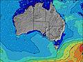 | 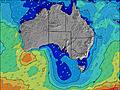 | 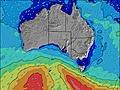 | 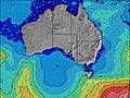 | 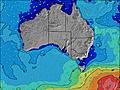 | 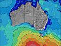 | |||||||||||
Wave Height (m) Direction Period (s) | SSW 15 | WSW 18 | SW 16 | WSW 15 | SW 15 | SW 14 | SW 14 | SW 14 | SW 13 | SW 13 | SW 13 | SW 13 | SW 12 | SW 12 | SW 14 | SW 14 | SW 14 | SW 14 |
Wave Graph | ||||||||||||||||||
584 | 1880 | 2259 | 2716 | 1669 | 1382 | 1163 | 1115 | 859 | 780 | 690 | 604 | 398 | 398 | 450 | 401 | 297 | 280 | |
Wind (km/h) | ||||||||||||||||||
Wind State on-shore cross-onshore cross-shore cross-offshore off-shore glassy | cross-off | cross-off | cross-off | cross-off | cross | cross-off | cross-off | cross | cross | cross-on | cross-on | cross-on | glassy | cross-off | cross | cross-off | glassy | cross |
High Tide | 3:48PM0.94m | 4:17AM0.69m | 4:06PM0.85m | 4:45AM0.76m | 4:21PM0.75m | |||||||||||||
Low Tide | 10:24PM0.15m | 9:54AM0.23m | 10:33PM0.15m | 10:33AM0.28m | ||||||||||||||
— | — | — | — | 7:16 | — | — | — | — | — | — | — | 7:15 | — | — | — | — | — | |
— | — | — | — | — | — | — | 5:39 | — | — | — | — | — | — | — | 5:40 | — | — | |
mm | — | — | — | — | — | — | — | — | — | — | — | — | — | — | — | — | — | — |
Temp °C | 14 | 14 | 13 | 13 | 13 | 14 | 13 | 12 | 12 | 12 | 12 | 12 | 11 | 11 | 12 | 12 | 11 | 10 |
Feels °C | 7 | 7 | 6 | 7 | 7 | 9 | 8 | 7 | 7 | 7 | 9 | 9 | 9 | 8 | 10 | 10 | 10 | 8 |
Swell 1 Height (m) Direction Period (s) | SSW 15 | SSW 15 | SSW 16 | WSW 15 | SW 15 | SW 14 | SW 14 | SW 14 | SW 13 | SW 13 | SW 13 | SW 13 | SW 12 | SW 12 | SW 14 | SW 14 | SW 14 | SW 14 |
584 | 372 | 412 | 2716 | 1669 | 1382 | 1163 | 696 | 859 | 780 | 690 | 604 | 398 | 398 | 450 | 401 | 297 | 280 | |
Swell 2 Height (m) Direction Period (s) | SW 19 | SSW 18 | — | — | — | — | — | — | SW 18 | SW 18 | SSW 18 | — | SSW 16 | SW 15 | SW 15 | — | SW 21 | SSW 21 |
58 | 209 | — | — | — | — | — | — | 81 | 81 | 31 | — | 175 | 145 | 143 | — | 112 | 171 | |
Swell 3 Height (m) Direction Period (s) | — | — | — | — | — | — | — | — | — | — | — | — | — | — | — | — | — | — |
— | — | — | — | — | — | — | — | — | — | — | — | — | — | — | — | — | — | |
Wind waves Height (m) Direction Period (s) | WSW 6 | WSW 18 | SW 16 | SW 16 | — | — | — | SW 14 | — | — | — | — | — | — | — | — | — | — |
161 | 1880 | 2259 | 2009 | — | — | — | 1115 | — | — | — | — | — | — | — | — | — | — | |
Nearest Offshore or Glassy | ||||||||||||||||||
Distance (km) | 152 | 535 | 535 | 535 | 159 | 509 | 510 | 510 | 711 | 26 | 12 | 24 | 0 | 0 | 5 | 0 | 0 | 11 |
Best forecast wave conditions in Yorke Peninsula | ||||||||||||||||||
Best forecast wave conditions in Australia | ||||||||||||||||||
Header Global | ||||||||||||||||||
- Map Icons:
 Break
Break Live Wave Height (m)
 Live Wind Speed (km/h)
 Surf Rating (10 Max)
 Ocean Swells (m)
- Wind Speed (km/h)
Latest Updates


FREE! Surf-Forecast.com widget for your website
The surf report / weather widget below is available to embed on third party websites free of charge and provides a summary of our A-Bay (Willyama Bay) surf forecast. Simply grab the html code snippet that we provide and paste it into your own site. You can choose your preferred language and metric/imperial units for the surf forecast feed to suit users of your site. Click here to get the code.
 Nearest