

Surf Forecasts:

The Wharf surf forecast from 3 Aug 2026:
- Best quality surf: Monday 3 Aug, 7PM (local time) - 2.5ft (0.8m), 11s period, SSE swell with glassy winds.
- Most powerful swell: Monday 10 Aug, 7AM (local time) - 10ft (3.0m), 16s period, SSE swell with 4,295 kJ wave energy.
- Next surfable swell (1★+): Monday 3 Aug, 7PM (local time) - 2.5ft (0.8m), 11s period with SSE swell.
Best Forecast Surf Conditions for The Wharf this week:
The surf forecast for The Wharf over the next 16 days: The first swell (rated 1 star or higher) is forecast to arrive on Monday (Aug 03) at 7PM. The primary swell is predicted to be 0.6m and 14s period with a secondary swell of 0.8m and 11s. The wind is predicted to be glassy as the swell arrives.
The most powerful waves expected at The Wharf in the next 16 days are 3.0m 16s and forecast to arrive on Monday (Aug 10) at 7AM. Winds are predicted to be onshore at the time the swell arrives. The largest open ocean swell (not directed at the beach) is 0.7m 8s period and expected on Monday (Aug 03) at 4PM.
| Wave Type | Time (+13) & Date | Wave Height & Period |
|---|---|---|
| Next good surf (1 star+) | 7PM (Mon 3rd Aug) | 2.5ft (0.8m) 11s |
| Best Surf | 7PM (Mon 3rd Aug) | 2.5ft (0.8m) 11s |
| Most Powerful | 7AM (Mon 10th Aug) | 10ft (3.0m) 16s |
Table - best surf conditions forecast for The Wharf over the next 16 days.
The Lowdown
Alright, let’s get into it. The next couple of weeks are gonna be a bit of a mixed bag, and honestly, for a while there, it’s looking pretty grim. We’ve got a solid spot to keep an eye on, but you’re gonna have to be patient and pick your moments.
The first real window of opportunity is Tuesday morning, August 4th. After a couple of rough, stormy days, we finally see the wind back off and go glassy. That’s the kind of calm that has me itching to get wet. The swell is small, only 2ft from the SW with a 13-second period, but when it’s that clean, it’s all about the quality of the wave, not the size. The combined energy is moderate (289), so it’ll have a little push to it. This is your go-to for a peaceful, cruisy session.
From there, things go downhill fast. The rest of that week and the weekend are a write-off. The wind swings onshore and gets fresh to strong, the sea gets lumpy and messy, and the swell mixes up. We even see some proper size on Monday, August 10th, with waves hitting 10ft, but it’s coming with a 35 km/h onshore wind and a stormy sky. That’s not surfable for a paddle; that’s just a washing machine. The combined energy is significant (6013 on the afternoon), but it’s all wasted on junky conditions. That setup is far more interesting for a kite surfer than anyone with a paddle in their hand.
The middle of next week doesn’t offer much either. We get a little bit of size on Wednesday the 12th, with 4ft in the morning, but the onshore wind ruins it. It’s not until the very end of the forecast period, around Tuesday, August 18th, that things start to look interesting again. We see the wind drop back to a moderate breeze, and the swell fills in with some proper long-period energy – 4ft from the SW at 18 seconds. The combined energy for that afternoon is strong (1011). This is a promising sign for the future, but it’s far out, so we’ll have to see if it holds.
So, to sum it up: if you want a clean wave, you gotta be quick. Tuesday morning, August 4th, at The Wharf is your best bet. After that, it’s a waiting game until next Tuesday, August 18th, for that longer-period groundswell to show up. Keep your expectations in check for the rest of it.
Rusty out.
Short Range ForecastModerate rain (total 17mm), heaviest on Wed night. Warm (max 27°C on Mon afternoon, min 25°C on Tue afternoon). Winds increasing (calm on Mon night, fresh winds from the SSE by Wed night). | Days 4-6 Weather SummaryHeavy rain (total 23mm), heaviest during Thu morning. Warm (max 25°C on Thu morning, min 24°C on Thu afternoon). Mainly strong winds. | ||||||||||||||||||||
Monday 3 | Tuesday 4 | Wednesday 5 | Thursday 6 | Friday 7 | Saturday 8 | Sunday 9 | |||||||||||||||
AM | PM | Night | AM | PM | Night | AM | PM | Night | AM | PM | Night | AM | PM | Night | AM | PM | Night | AM | PM | Night | |
Swell Height Map |  | 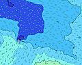 | 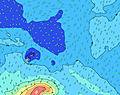 | 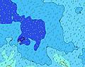 | 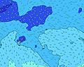 | 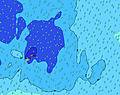 | 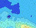 | ||||||||||||||
Wave Height (m) Direction Period (s) | SSE 11 | SW 15 | SW 14 | SW 13 | SW 13 | SW 13 | SSW 13 | SSW 13 | S 12 | S 12 | SSE 7 | SE 7 | SSE 8 | SSE 8 | SSE 9 | SE 9 | SSE 9 | SE 9 | S 9 | SE 9 | S 18 |
Wave Graph | |||||||||||||||||||||
197 | 171 | 208 | 180 | 178 | 162 | 236 | 433 | 404 | 327 | 288 | 405 | 692 | 486 | 732 | 880 | 982 | 866 | 505 | 750 | 1543 | |
Wind (km/h) | |||||||||||||||||||||
Wind State on-shore cross-onshore cross-shore cross-offshore off-shore glassy | cross | cross | glassy | glassy | cross-on | cross-on | cross-on | cross-on | cross-on | cross-on | cross-on | cross-on | cross-on | cross-on | on | on | on | on | on | on | on |
High Tide | 9:59PM1.01m | 10:14AM0.98m | 10:49PM1.02m | 11:11AM0.95m | 11:47PM1.03m | 12:17PM0.92m | 00:51AM1.05m | 1:28PM0.92m | 1:57AM1.10m | 2:36PM0.95m | 3:00AM1.16m | 3:39PM1.00m | 4:00AM1.22m | ||||||||
Low Tide | 3:39PM0.24m | 4:04AM0.29m | 4:24PM0.26m | 5:01AM0.30m | 5:18PM0.28m | 6:06AM0.29m | 6:19PM0.28m | 7:17AM0.26m | 7:27PM0.27m | 8:27AM0.20m | 8:34PM0.23m | 9:31AM0.13m | 9:37PM0.17m | ||||||||
6:48 | — | — | 6:48 | — | — | 6:48 | — | — | 6:48 | — | — | 6:47 | — | — | 6:47 | — | — | 6:47 | — | — | |
— | 6:21 | — | — | 6:21 | — | — | 6:21 | — | — | 6:21 | — | — | 6:21 | — | — | 6:21 | — | — | 6:22 | — | |
mm | 1 | 1 | — | — | 1 | 1 | 2 | 3 | 8 | 3 | 1 | 4 | 2 | 1 | 1 | 4 | 2 | 5 | 2 | 2 | 5 |
Temp °C | 26 | 27 | 27 | 26 | 26 | 25 | 25 | 25 | 25 | 25 | 24 | 24 | 24 | 24 | 25 | 24 | 25 | 25 | 26 | 26 | 25 |
Feels °C | 28 | 31 | 31 | 30 | 28 | 26 | 26 | 26 | 26 | 23 | 22 | 21 | 20 | 20 | 22 | 20 | 21 | 20 | 23 | 24 | 23 |
Swell 1 Height (m) Direction Period (s) | SSE 11 | SSE 11 | SE 11 | SW 13 | SW 13 | SW 13 | SSW 13 | SSW 13 | S 12 | S 12 | S 11 | SW 16 | S 15 | S 15 | S 14 | S 14 | SW 14 | S 13 | S 9 | S 20 | S 18 |
197 | 160 | 126 | 180 | 178 | 162 | 236 | 433 | 404 | 327 | 240 | 258 | 218 | 283 | 293 | 637 | 46 | 324 | 505 | 610 | 1543 | |
Swell 2 Height (m) Direction Period (s) | SW 15 | SW 15 | SW 14 | SSE 11 | SSE 10 | S 15 | SW 13 | SW 20 | SW 18 | SW 17 | SW 17 | S 16 | SW 16 | ENE 8 | S 16 | SW 14 | NE 11 | SSW 13 | S 21 | SSW 13 | SW 12 |
176 | 171 | 208 | 109 | 72 | 157 | 128 | 186 | 260 | 302 | 288 | 186 | 201 | 53 | 193 | 52 | 5 | 16 | 81 | 16 | 6 | |
Swell 3 Height (m) Direction Period (s) | NE 11 | NE 11 | ENE 8 | ENE 8 | ENE 8 | SE 10 | S 6 | ENE 8 | SW 11 | NE 8 | NE 8 | S 11 | ENE 13 | SW 15 | SW 14 | NE 11 | NE 13 | SW 20 | SSW 13 | SW 19 | NW 14 |
18 | 29 | 34 | 24 | 21 | 51 | 22 | 23 | 64 | 24 | 18 | 60 | 16 | 112 | 103 | 5 | 7 | 16 | 17 | 14 | 8 | |
Wind waves Height (m) Direction Period (s) | ENE 8 | ENE 8 | — | — | — | SSE 4 | ESE 3 | SSE 6 | SE 9 | SSE 6 | SSE 7 | SE 7 | SSE 8 | SSE 8 | SSE 9 | SE 9 | SSE 9 | SE 9 | E 9 | SE 9 | SE 9 |
56 | 55 | — | — | — | 21 | 3 | 18 | 67 | 74 | 282 | 405 | 692 | 486 | 732 | 880 | 982 | 866 | 304 | 750 | 764 | |
Nearest Offshore or Glassy | |||||||||||||||||||||
Distance (km) | 42 | 9 | 0 | 0 | 59 | 162 | 1565 | 162 | 1565 | 1565 | 2245 | 2245 | 2249 | 2297 | 1214 | 1221 | 1214 | 1214 | 1214 | 2249 | 1191 |
Best forecast wave conditions in Savaii | |||||||||||||||||||||
Best forecast wave conditions in Samoa | |||||||||||||||||||||
Header Global | |||||||||||||||||||||
- Map Icons:
 Break
Break Live Wave Height (m)
 Live Wind Speed (km/h)
 Surf Rating (10 Max)
 Ocean Swells (m)
- Wind Speed (km/h)
Latest Updates


FREE! Surf-Forecast.com widget for your website
The surf report / weather widget below is available to embed on third party websites free of charge and provides a summary of our The Wharf surf forecast. Simply grab the html code snippet that we provide and paste it into your own site. You can choose your preferred language and metric/imperial units for the surf forecast feed to suit users of your site. Click here to get the code.
Information about the The Wharf Surf forecast
The above surf forecast table for The Wharf provides essential information for determining whether the surfing conditions will be good over the next 16 days. A general guide to surfing at The Wharf can be found by selecting the local surf guide option on the grey menu. Our The Wharf surf forecast is unique since it includes wave energy (power) that defines the real feel of the surf rather than just the height or the period. If you surf the same spot (The Wharf) regularly then make a mental note of the wave energy from the surf forecast table each time you go. Very soon you may start to choose your surf days based on the wave energy alone combined with our forecast of favourable offshore wind conditions. Our star ratings will help here and of course you will also find the usual wave height and period predictions on our surf forecasts as well as a full break down of the swell components under our advanced users option (to reveal that, click the little Einstein character under the tide times).
Further information to help with frequently asked questions about our surf forecast for The Wharf may be found under the help tab on the top menu and also by moving your mouse over the question marks on the surf forecast table itself. Please always bear in mind that the forecast is for near-shore open water and local factors at each surf break influence the actual breaking wave height, such as the beach / reef profile, water depths offshore and shelter.
Are you planning a holiday in East Sepik? If you are looking for accommodation near The Wharf (Mission Point), camping, hotels and holiday cottages in East Sepik, consider staying in Wewak which is 5 km (3 miles) away.
 Nearest