

Surf Forecasts:

South Moana Reefs surf forecast from 14 Jul 2026:
- Most powerful swell: Monday 20 Jul, 12PM (local time) - 2.5ft (0.8m), 4s period, NNW swell with 18 kJ wave energy.
Best Forecast Surf Conditions for South Moana Reefs this week:
The most powerful waves expected at South Moana Reefs in the next 16 days are 0.8m 4s and forecast to arrive on Monday (Jul 20) at 12PM. Winds are predicted to be cross-shore at the time the swell arrives. The largest open ocean swell (not directed at the beach) is 0.7m 5s period and expected on Tuesday (Jul 14) at 12PM.
| Wave Type | Time (ACST) & Date | Wave Height & Period |
|---|---|---|
| Next good surf (1 star+) | - | - |
| Best Surf | - | - |
| Most Powerful | 12PM (Mon 20th Jul) | 2.5ft (0.8m) 4s |
Table - best surf conditions forecast for South Moana Reefs over the next 16 days.
The Lowdown
Alright folks, let’s talk about South Moana Reefs. I’ve looked at the charts, and honestly, it’s a tough stretch ahead. This is an inconsistent spot that’s pretty sheltered, so it needs a lot of things to line up, and for the next two weeks, it just doesn’t happen.
The water temp is sitting at 58°F, which is a touch cooler than average for this time of year – nothing crazy, but you’ll feel it.
The first sign of any real swell shows up on the morning of Tuesday, July 29th. That’s a whole 16 days of waiting. Before that, we’re looking at a long, quiet run. Most days are flat, with tiny dribbles of swell that are mostly under 0.3ft, and the wind is all over the place – from glassy to cross-off to cross-onshore. The wave energy is basically zero for most of it, with readings like 49 (weak energy) on the 14th, and then dropping to single digits or zero for days on end. There’s nothing to get excited about.
So, the only real shot in the whole window is that Tuesday, July 29th. The morning shapes up with a clean, glassy surface and a 4ft swell from the west. That’s the biggest swell of the period, but even then, the period is short (5 seconds), so it’s gonna be a bit weak and messy. The energy is still only moderate at 80. It’s rideable for the die-hards who are desperate, but it’s not a standout. The wind turns a bit cross-onshore in the afternoon, so if you’re gonna paddle out, make it an early one.
But honestly, for a spot that needs a WSW swell and a clean wind, this is a real dry spell. For the next 15 days, you’re looking at gaps of flat, sub-par conditions. The only real chance is that one morning on the 29th. Keep an eye on it, but don’t hold your breath.
Rusty.
Short Range ForecastMostly dry. Very mild (max 14°C on Tue morning, min 10°C on Tue night). Wind will be generally light. | Days 4-6 Weather SummaryMostly dry. Very mild (max 16°C on Sat afternoon, min 11°C on Fri morning). Wind will be generally light. | ||||||||||||||||||||
Tuesday 14 | Wednesday 15 | Thursday 16 | Friday 17 | Saturday 18 | Sunday 19 | Monday 20 | |||||||||||||||
AM | PM | Night | AM | PM | Night | AM | PM | Night | AM | PM | Night | AM | PM | Night | AM | PM | Night | AM | PM | Night | |
Swell Height Map | 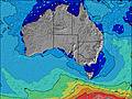 | 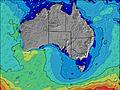 | 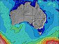 | 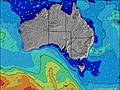 | 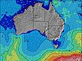 | 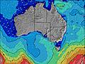 | 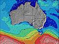 | ||||||||||||||
Wave Height (m) Direction Period (s) | WSW 5 | S 15 | WSW 8 | S 14 | S 15 | S 14 | S 13 | S 17 | W 8 | S 14 | S 16 | S 15 | SW 14 | SW 13 | W 11 | N 3 | NNW 3 | S 16 | N 4 | NNW 4 | SW 13 |
Wave Graph | |||||||||||||||||||||
44 | 5 | 0 | 4 | 4 | 4 | 4 | 6 | 0 | 4 | 5 | 4 | 8 | 7 | 0 | 5 | 4 | 5 | 14 | 10 | 7 | |
Wind (km/h) | |||||||||||||||||||||
Wind State on-shore cross-onshore cross-shore cross-offshore off-shore glassy | cross-on | on | glassy | glassy | glassy | off | glassy | glassy | cross-off | cross-off | glassy | cross-off | cross-off | cross-on | cross-off | cross | cross-on | cross-off | cross | cross | cross-off |
High Tide | 4:40PM2.14m | 6:06AM1.28m | 5:13PM2.16m | 6:16AM1.32m | 5:39PM2.13m | 6:22AM1.39m | 6:01PM2.09m | 6:31AM1.52m | 6:21PM2.02m | 6:47AM1.66m | 6:41PM1.94m | 7:11AM1.79m | 7:04PM1.83m | ||||||||
Low Tide | 10:00AM0.95m | 11:59PM0.29m | 10:36AM0.84m | 00:19AM0.33m | 11:04AM0.75m | 00:32AM0.40m | 11:31AM0.68m | 00:40AM0.46m | 11:59AM0.64m | 00:48AM0.49m | 12:29PM0.63m | 1:00AM0.48m | 1:03PM0.67m | 1:18AM0.48m | |||||||
7:22 | — | — | 7:22 | — | — | 7:22 | — | — | 7:20 | — | — | 7:20 | — | — | 7:20 | — | — | 7:20 | — | — | |
— | 5:21 | — | — | 5:21 | — | — | 5:22 | — | — | 5:22 | — | — | 5:22 | — | — | 5:23 | — | — | 5:24 | — | |
mm | — | — | — | — | — | — | — | — | — | — | — | — | — | — | — | — | — | — | — | — | — |
Temp °C | 14 | 14 | 13 | 12 | 12 | 12 | 12 | 13 | 13 | 13 | 14 | 14 | 15 | 16 | 15 | 15 | 16 | 15 | 15 | 16 | 15 |
Feels °C | 11 | 12 | 13 | 11 | 11 | 11 | 10 | 12 | 11 | 11 | 12 | 12 | 12 | 15 | 11 | 11 | 14 | 11 | 10 | 12 | 11 |
Swell 1 Height (m) Direction Period (s) | S 15 | W 5 | WSW 8 | WSW 8 | WSW 8 | WSW 8 | WSW 8 | W 8 | W 8 | W 8 | W 8 | W 9 | SW 14 | SW 13 | W 11 | SW 9 | W 9 | W 9 | WSW 10 | WSW 10 | W 5 |
5 | 13 | 21 | 12 | 12 | 6 | 6 | 5 | 1 | 1 | 1 | 1 | 8 | 7 | 2 | 3 | 2 | 1 | 10 | 10 | 5 | |
Swell 2 Height (m) Direction Period (s) | — | WSW 8 | — | S 14 | S 15 | S 14 | S 13 | S 17 | — | S 14 | S 16 | S 15 | W 7 | W 5 | — | W 5 | — | — | — | — | WSW 9 |
— | 6 | — | 4 | 4 | 4 | 4 | 6 | — | 4 | 5 | 4 | 1 | 1 | — | 1 | — | — | — | — | 8 | |
Swell 3 Height (m) Direction Period (s) | — | S 15 | — | — | — | — | — | — | — | — | — | — | — | — | — | — | — | S 16 | — | — | SW 13 |
— | 5 | — | — | — | — | — | — | — | — | — | — | — | — | — | — | — | 5 | — | — | 7 | |
Wind waves Height (m) Direction Period (s) | WSW 5 | — | — | — | — | — | — | — | — | NNE 3 | N 3 | — | NNE 3 | N 3 | — | N 3 | NNW 3 | NNE 2 | N 4 | NNW 4 | N 3 |
44 | — | — | — | — | — | — | — | — | 1 | 1 | — | 3 | 2 | — | 5 | 4 | 1 | 14 | 10 | 1 | |
Nearest Offshore or Glassy | |||||||||||||||||||||
Distance (km) | 616 | 615 | 41 | 41 | 47 | 41 | 41 | 41 | 41 | 41 | 41 | 41 | 41 | 41 | 41 | 41 | 41 | 41 | 41 | 41 | 41 |
Best forecast wave conditions in Adelaide | |||||||||||||||||||||
Best forecast wave conditions in Australia | |||||||||||||||||||||
Header Global | |||||||||||||||||||||
- Map Icons:
 Break
Break Live Wave Height (m)
 Live Wind Speed (km/h)
 Surf Rating (10 Max)
 Ocean Swells (m)
- Wind Speed (km/h)


FREE! Surf-Forecast.com widget for your website
The surf report / weather widget below is available to embed on third party websites free of charge and provides a summary of our South Moana Reefs surf forecast. Simply grab the html code snippet that we provide and paste it into your own site. You can choose your preferred language and metric/imperial units for the surf forecast feed to suit users of your site. Click here to get the code.
Information about the South Moana Reefs Surf forecast
The above surf forecast table for South Moana Reefs provides essential information for determining whether the surfing conditions will be good over the next 16 days. A general guide to surfing at South Moana Reefs can be found by selecting the local surf guide option on the grey menu. Our South Moana Reefs surf forecast is unique since it includes wave energy (power) that defines the real feel of the surf rather than just the height or the period. If you surf the same spot (South Moana Reefs) regularly then make a mental note of the wave energy from the surf forecast table each time you go. Very soon you may start to choose your surf days based on the wave energy alone combined with our forecast of favourable offshore wind conditions. Our star ratings will help here and of course you will also find the usual wave height and period predictions on our surf forecasts as well as a full break down of the swell components under our advanced users option (to reveal that, click the little Einstein character under the tide times).
Further information to help with frequently asked questions about our surf forecast for South Moana Reefs may be found under the help tab on the top menu and also by moving your mouse over the question marks on the surf forecast table itself. Please always bear in mind that the forecast is for near-shore open water and local factors at each surf break influence the actual breaking wave height, such as the beach / reef profile, water depths offshore and shelter.
 Nearest