

Surf Forecasts:

Punta Roquitas surf forecast from 28 Jul 2026:
- Best quality surf: Saturday 1 Aug, 7AM (local time) - 4.5ft (1.3m), 7s period, S swell with glassy winds.
- Most powerful swell: Monday 27 Jul, 10PM (local time) - 5ft (1.5m), 16s period, SW swell with 1,123 kJ wave energy.
- Next surfable swell (1★+): Saturday 1 Aug, 7AM (local time) - 4.5ft (1.3m), 7s period with S swell.
Best Forecast Surf Conditions for Punta Roquitas this week:
The surf forecast for Punta Roquitas over the next 16 days: The first swell (rated 1 star or higher) is forecast to arrive on Saturday (Aug 01) at 7AM. The primary swell is predicted to be 1.3m and 7s period with a secondary swell of 0.8m and 11s. The wind is predicted to be glassy as the swell arrives.
The most powerful waves expected at Punta Roquitas in the next 16 days are 1.5m 16s and forecast to arrive on Monday (Jul 27) at 10PM. Winds are predicted to be cross-shore at the time the swell arrives.
| Wave Type | Time (-05) & Date | Wave Height & Period |
|---|---|---|
| Next good surf (1 star+) | 7AM (Sat 1st Aug) | 4.5ft (1.3m) 7s |
| Best Surf | 7AM (Sat 1st Aug) | 4.5ft (1.3m) 7s |
| Most Powerful | 10PM (Mon 27th Jul) | 5ft (1.5m) 16s |
Table - best surf conditions forecast for Punta Roquitas over the next 16 days.
The Lowdown
Alright, this is Rusty comin' at ya from the shores of Punta Roquitas. Let's get into it.
Right off the bat, we've got a bit of a slow start. The water is sitting at a balmy 72°F, which is a whopping 9°F warmer than normal for this time of year. That's a real tropical feel, which is pretty unusual.
The first few days are a bit of a write-off. Monday and Tuesday are looking pretty average with a cross-onshore wind messing up the surface. The swell is there, around 4ft to 5ft from the SW, but it's a long period groundswell (15 to 17 seconds), which can be a bit too straight for a beach break, and the wind isn't helping. The combined wave energy is moderate to strong (960 to 1118), but the conditions just aren't there for a good paddle.
Wednesday morning, the 29th of July, is the first real glimmer of hope. The wind swings around to a clean offshore from the SW, and it's light at 3 mph. The swell is still a solid 5ft from the SW with a period of 13 seconds. The energy is moderate (873). This is the best bet for a quiet session, especially for a beginner, as the size is manageable. Just be aware that the crowds are sometimes here, so you might have a few friends out.
Thursday through to the following Monday, the 4th of August, is a bit of a flat or messy spell. The winds stay cross-onshore, the swell drops off, and the scores are low. It's a gap of a few days where you're better off checking the wind apps or doing something else.
Now, the real standout window opens up on Thursday, the 6th of August. The morning (6 August) gets a very long period SW groundswell (18 seconds) with a combined energy of 1136. The swell is a modest 3ft, but that long period means it'll be lined up and clean. The wind is a light cross-onshore from the W, but it's light enough to keep things pretty tidy. This is a classic long-period point-break style of wave, which is perfect for Punta Roquitas.
Then, Friday the 7th of August is the pick of the whole forecast. The swell fills in to 4ft to 5ft from the SW, with a period of 14 to 15 seconds. The wind is a clean offshore from the SW, just a light breeze at 6 mph. The wave energy is strong (1327). This is going to be a proper day of surfing. The size is solid for a beginner, and the offshore wind will make the waves glassy. This is the one to circle on the calendar.
After that, the swell pulses up again around the 9th and 10th of August. The 9th (Sunday) has a solid 5ft to 5ft SSW swell with a period of 15 to 16 seconds, but the wind is a moderate cross-onshore, which chops it up. The 10th (Monday) has a bigger swell, hitting 7ft, but it's blown out by a 12 mph cross-onshore wind. That's too big and messy for a beginner session, and even for intermediates, it's going to be a battle.
The last real chance is the morning of Tuesday the 11th of August. The swell is 5ft from the SSW with a period of 11 seconds, and the wind is a gentle cross-onshore. It's a step down from the epic Friday, but still a fun, manageable size.
So, to wrap it up: the first week is a bit of a dud, but the 7th of August is the absolute standout. Get that date locked in for clean, offshore, shoulder-high waves. The 6th of August is also worth a look for the long-period glassy lines. Don't bother with the rest, unless you're keen on a messy paddle.
Rusty.
Short Range ForecastMostly dry. Warm (max 21°C on Tue morning, min 18°C on Mon night). Wind will be generally light. | Days 4-6 Weather SummaryMostly dry. Warm (max 21°C on Thu morning, min 18°C on Fri night). Wind will be generally light. | ||||||||||||||||||||
Monday 27 | Tuesday 28 | Wednesday 29 | Thursday 30 | Friday 31 | Saturday 1 | Sunday 2 | |||||||||||||||
AM | PM | Night | AM | PM | Night | AM | PM | Night | AM | PM | Night | AM | PM | Night | AM | PM | Night | AM | PM | Night | |
Swell Height Map | 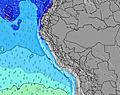 | 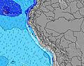 | 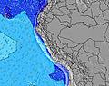 | 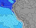 | 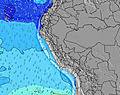 | 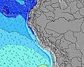 | 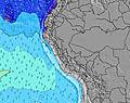 | ||||||||||||||
Wave Height (m) Direction Period (s) | SW 17 | SW 16 | SW 16 | SW 15 | SW 15 | SW 14 | SW 13 | SW 13 | SW 13 | SW 12 | SW 12 | SW 12 | SW 12 | SW 12 | SW 12 | SW 11 | SW 11 | SW 15 | SW 14 | S 8 | SW 13 |
Wave Graph | |||||||||||||||||||||
861 | 1042 | 1109 | 962 | 924 | 813 | 778 | 683 | 581 | 528 | 430 | 392 | 272 | 197 | 169 | 205 | 198 | 155 | 179 | 172 | 136 | |
Wind (km/h) | |||||||||||||||||||||
Wind State on-shore cross-onshore cross-shore cross-offshore off-shore glassy | cross-on | cross-on | cross | cross-on | cross-on | cross-on | on | on | cross-on | cross-on | cross-on | cross | cross-on | cross-on | cross-on | on | cross-on | cross-on | on | cross-on | cross |
High Tide | 4:20PM0.49m | 5:49AM0.88m | 4:59PM0.51m | 6:20AM0.91m | 5:36PM0.52m | 6:49AM0.92m | 6:15PM0.54m | 7:16AM0.92m | 6:54PM0.56m | 7:41AM0.90m | 7:36PM0.57m | 8:06AM0.87m | 8:22PM0.59m | ||||||||
Low Tide | 11:54AM0.34m | 10:30PM0.11m | 12:25PM0.33m | 11:05PM0.10m | 12:55PM0.32m | 11:38PM0.10m | 1:24PM0.31m | 00:10AM0.12m | 1:52PM0.29m | 00:42AM0.16m | 2:19PM0.28m | 1:15AM0.21m | 2:45PM0.26m | 1:52AM0.28m | |||||||
6:28 | — | — | 6:28 | — | — | 6:26 | — | — | 6:26 | — | — | 6:26 | — | — | 6:26 | — | — | 6:26 | — | — | |
— | 6:00 | — | — | 6:00 | — | — | 6:00 | — | — | 6:00 | — | — | 6:01 | — | — | 6:01 | — | — | 6:01 | — | |
mm | — | — | — | — | — | — | — | — | — | — | — | — | — | — | — | — | — | — | — | — | — |
Temp °C | 20 | 20 | 19 | 21 | 20 | 19 | 21 | 21 | 19 | 21 | 21 | 19 | 20 | 20 | 19 | 21 | 20 | 19 | 20 | 20 | 19 |
Feels °C | 19 | 19 | 18 | 21 | 19 | 19 | 21 | 21 | 20 | 21 | 21 | 18 | 19 | 18 | 18 | 21 | 20 | 18 | 20 | 20 | 20 |
Swell 1 Height (m) Direction Period (s) | SW 17 | SW 16 | SW 16 | SW 15 | SW 15 | SW 14 | SW 13 | SW 13 | SW 13 | SW 12 | SW 12 | SW 12 | SW 12 | SW 12 | S 6 | S 7 | SW 11 | S 7 | S 8 | S 8 | S 7 |
861 | 1042 | 1109 | 962 | 924 | 813 | 778 | 683 | 581 | 528 | 430 | 392 | 272 | 197 | 119 | 150 | 198 | 155 | 163 | 172 | 108 | |
Swell 2 Height (m) Direction Period (s) | S 6 | SW 9 | S 6 | S 7 | S 7 | S 7 | S 7 | S 7 | S 7 | S 6 | S 11 | S 11 | SW 16 | S 10 | SW 12 | SW 11 | SW 15 | SW 10 | SW 10 | SW 10 | SW 13 |
41 | 20 | 62 | 94 | 97 | 97 | 77 | 77 | 45 | 19 | 61 | 61 | 11 | 50 | 169 | 205 | 109 | 150 | 117 | 76 | 136 | |
Swell 3 Height (m) Direction Period (s) | SW 10 | — | S 9 | S 11 | S 11 | S 10 | S 10 | WNW 13 | S 12 | S 11 | W 12 | SW 20 | — | SW 17 | SW 16 | SW 16 | W 12 | SW 15 | SW 14 | SW 13 | SW 10 |
58 | — | 6 | 10 | 21 | 18 | 18 | 17 | 25 | 41 | 3 | 16 | — | 45 | 90 | 89 | 3 | 134 | 179 | 140 | 57 | |
Wind waves Height (m) Direction Period (s) | — | S 7 | — | — | — | — | — | — | — | — | S 6 | S 4 | S 10 | S 4 | — | — | S 7 | — | — | — | — |
— | 56 | — | — | — | — | — | — | — | — | 19 | 8 | 100 | 12 | — | — | 134 | — | — | — | — | |
Nearest Offshore or Glassy | |||||||||||||||||||||
Distance (km) | 7 | 7 | 34 | 7 | 7 | 6 | 7 | 7 | 6 | 7 | 7 | 32 | 7 | 7 | 6 | 7 | 7 | 7 | 7 | 7 | 6 |
Best forecast wave conditions in Lima | |||||||||||||||||||||
Best forecast wave conditions in Peru | |||||||||||||||||||||
Header Global | |||||||||||||||||||||
- Map Icons:
 Break
Break Live Wave Height (m)
 Live Wind Speed (km/h)
 Surf Rating (10 Max)
 Ocean Swells (m)
- Wind Speed (km/h)


FREE! Surf-Forecast.com widget for your website
The surf report / weather widget below is available to embed on third party websites free of charge and provides a summary of our Punta Roquitas surf forecast. Simply grab the html code snippet that we provide and paste it into your own site. You can choose your preferred language and metric/imperial units for the surf forecast feed to suit users of your site. Click here to get the code.
Information about the Punta Roquitas Surf forecast
The above surf forecast table for Punta Roquitas provides essential information for determining whether the surfing conditions will be good over the next 16 days. A general guide to surfing at Punta Roquitas can be found by selecting the local surf guide option on the grey menu. Our Punta Roquitas surf forecast is unique since it includes wave energy (power) that defines the real feel of the surf rather than just the height or the period. If you surf the same spot (Punta Roquitas) regularly then make a mental note of the wave energy from the surf forecast table each time you go. Very soon you may start to choose your surf days based on the wave energy alone combined with our forecast of favourable offshore wind conditions. Our star ratings will help here and of course you will also find the usual wave height and period predictions on our surf forecasts as well as a full break down of the swell components under our advanced users option (to reveal that, click the little Einstein character under the tide times).
Further information to help with frequently asked questions about our surf forecast for Punta Roquitas may be found under the help tab on the top menu and also by moving your mouse over the question marks on the surf forecast table itself. Please always bear in mind that the forecast is for near-shore open water and local factors at each surf break influence the actual breaking wave height, such as the beach / reef profile, water depths offshore and shelter.
Punta Roquitas is 1 km (1 miles) from the city of Lima. If you plan a holiday in Lima, look for hotels and other accommodation in Lima. Lima has rooms for a wide range of budgets as well as car hire and transport links.
 Nearest