

Surf Forecasts:

Papanoa surf forecast from 1 Aug 2026:
- Best quality surf: Friday 7 Aug, 3AM (local time) - 2.5ft (0.7m), 18s period, SSW swell with offshore winds.
- Most powerful swell: Saturday 8 Aug, 12AM (local time) - 3.5ft (1.1m), 16s period, SSW swell with 627 kJ wave energy.
- Next surfable swell (1★+): Saturday 1 Aug, 3AM (local time) - 3.5ft (1.0m), 13s period with SSW swell.
Best Forecast Surf Conditions for Papanoa this week:
The surf forecast for Papanoa over the next 16 days: The first swell (rated 1 star or higher) is forecast to arrive on Saturday (Aug 01) at 3AM. The primary swell is predicted to be 1.0m and 13s period with a secondary swell of 0.5m and 9s. The wind is predicted to be offshore as the swell arrives.
The most powerful waves expected at Papanoa in the next 16 days are 1.1m 16s and forecast to arrive on Saturday (Aug 08) at 12AM. Winds are predicted to be glassy at the time the swell arrives.
| Wave Type | Time (CST) & Date | Wave Height & Period |
|---|---|---|
| Next good surf (1 star+) | 3AM (Sat 1st Aug) | 3.5ft (1.0m) 13s |
| Best Surf | 3AM (Fri 7th Aug) | 2.5ft (0.7m) 18s |
| Most Powerful | 12AM (Sat 8th Aug) | 3.5ft (1.1m) 16s |
Table - best surf conditions forecast for Papanoa over the next 16 days.
The Lowdown
Alright folks, Rusty here. Let’s have a look at what’s coming down the pipe for the next couple of weeks.
The first few days are a bit of a write-off, to be honest. We’ve got some swell, but the wind is all over the place and the conditions are just messy. It’s not until Sunday the 2nd that things start to clean up. The water is sitting at a warm 88° here, which is about a touch warmer than normal for the time of year. That’s nice.
Sunday the 2nd is the first real glimmer of hope. Early morning at Papanoa, we’ll see a glassy, clean surface with a light 2ft SSW swell. The energy is moderate (263), and it’s a nice little groundswell with a 12-second period. Perfect for a longboard or a funboard, real chilled out session before the afternoon wind ruins it.
The pattern after that is a bit of a tease. Monday the 3rd morning looks clean again with a cross-offshore breeze and a 3ft SSW swell, period pushing 14 seconds. That’s a decent little wave, moderate energy (356). But the afternoons keep getting chopped by the sea breeze.
Now, the real standout is the window from Friday the 7th of August right through to Saturday the 15th. This is where we get a proper run of long-period groundswell, and the mornings are looking absolutely pristine.
Friday the 7th morning is a beaut. Glassy conditions, 3ft of SSW swell at a very long 18 seconds. The energy is strong (710). That’s a proper groundswell that will wrap in nicely. This is expert territory for the power, but the wave quality will be top-shelf.
Saturday the 8th morning is even better. 4ft of SSW swell, still 16 seconds, glassy. The energy is strong (750). This is one of the best calls of the whole period.
Tuesday the 11th morning, Wednesday the 12th morning, Friday the 14th morning, and Saturday the 15th morning all repeat the formula: glassy or near-calm winds, consistent 3ft to 4ft SW groundswell, and periods hanging around 14 to 16 seconds. The energy stays strong, hitting 846 on the 15th. Every single one of these mornings is a go.
The best on offer is undeniably Saturday the 8th morning. That 4ft, 16-second SSW groundswell with glassy conditions is going to be clean, lined-up, and have plenty of push. Get on it early. The only downside is that crowds are sometimes an issue here, so expect company.
The second-best call is Friday the 7th morning. That 18-second period is incredibly long, which means the sets will be fat and powerful, but be patient – the gaps between sets will be bigger. A true surfer’s swell.
If you’re a beginner, keep an eye on the smaller mornings like Sunday the 2nd or Tuesday the 4th (2ft), but for the best waves, stick to the early sessions from the 7th onwards.
Rusty.
Short Range ForecastHeavy rain (total 20mm), heaviest during Sat night. Warm (max 32°C on Fri afternoon, min 26°C on Sat night). Wind will be generally light. | Days 5-7 Weather SummaryHeavy rain (total 25mm), heaviest during Tue night. Warm (max 31°C on Mon afternoon, min 25°C on Tue night). Wind will be generally light. | |||||||||||||||||||
Fri 31 | Saturday 1 | Sunday 2 | Monday 3 | Tuesday 4 | Wednesday 5 | Thursday 6 | ||||||||||||||
PM | Night | AM | PM | Night | AM | PM | Night | AM | PM | Night | AM | PM | Night | AM | PM | Night | AM | PM | Night | |
Swell Height Map |  |  |  |  | 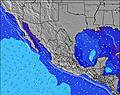 | 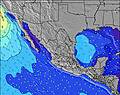 | 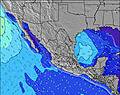 | |||||||||||||
Wave Height (m) Direction Period (s) | SSW 13 | SSW 13 | SSW 13 | SSW 13 | SSW 12 | SW 14 | SW 14 | SSW 14 | SSW 14 | SW 12 | SSW 13 | SSW 12 | SSW 12 | SSW 12 | SW 15 | SW 14 | SW 14 | SW 13 | SSW 18 | SSW 18 |
Wave Graph | ||||||||||||||||||||
451 | 346 | 257 | 253 | 161 | 123 | 147 | 180 | 261 | 159 | 114 | 101 | 98 | 96 | 134 | 130 | 125 | 173 | 214 | 214 | |
Wind (km/h) | ||||||||||||||||||||
Wind State on-shore cross-onshore cross-shore cross-offshore off-shore glassy | cross-on | cross-off | cross | cross-on | cross-off | glassy | cross-on | cross-off | cross-off | on | glassy | off | on | glassy | cross-off | on | off | glassy | cross-on | glassy |
High Tide | 4:40PM0.58m | 6:29AM0.39m | 5:34PM0.57m | 6:56AM0.48m | 6:09PM0.55m | 7:20AM0.57m | 6:32PM0.52m | 7:44AM0.65m | 6:48PM0.50m | 8:10AM0.72m | 7:03PM0.50m | 8:39AM0.78m | 7:23PM0.50m | |||||||
Low Tide | 1:06AM0.34m | 9:57AM0.37m | 00:32AM0.32m | 11:53AM0.37m | 00:32AM0.28m | 12:59PM0.36m | 00:42AM0.22m | 1:44PM0.35m | 00:59AM0.16m | 2:20PM0.34m | 1:21AM0.08m | 2:52PM0.34m | 1:50AM0.01m | |||||||
— | — | 6:22 | — | — | 6:22 | — | — | 6:22 | — | — | 6:22 | — | — | 6:22 | — | — | 6:24 | — | — | |
7:15 | — | — | 7:15 | — | — | 7:15 | — | — | 7:15 | — | — | 7:14 | — | — | 7:14 | — | — | 7:13 | — | |
mm | — | — | — | — | 12 | 1 | 2 | 5 | — | 1 | 4 | 1 | 3 | 15 | — | — | 1 | — | — | 17 |
Temp °C | 32 | 28 | 32 | 32 | 28 | 31 | 31 | 28 | 31 | 31 | 29 | 31 | 31 | 28 | 31 | 30 | 28 | 31 | 31 | 28 |
Feels °C | 33 | 31 | 34 | 33 | 32 | 35 | 34 | 33 | 35 | 34 | 35 | 34 | 35 | 34 | 34 | 33 | 33 | 34 | 33 | 32 |
Swell 1 Height (m) Direction Period (s) | SSW 13 | SSW 13 | SSW 13 | SSW 13 | SSW 12 | SSW 12 | SSW 12 | SSW 14 | SSW 14 | SW 12 | SSW 13 | S 8 | S 8 | S 8 | S 9 | S 9 | S 8 | SW 13 | SW 13 | SW 13 |
451 | 346 | 257 | 253 | 161 | 123 | 147 | 180 | 261 | 159 | 114 | 49 | 66 | 64 | 76 | 76 | 69 | 173 | 212 | 190 | |
Swell 2 Height (m) Direction Period (s) | W 10 | W 9 | SW 15 | SW 15 | SW 14 | SW 14 | W 6 | W 6 | W 6 | S 8 | SSE 9 | SSW 12 | SSW 12 | SSW 12 | SW 15 | SW 14 | SW 14 | S 8 | S 8 | SSW 18 |
48 | 43 | 115 | 107 | 132 | 121 | 22 | 21 | 15 | 34 | 25 | 101 | 98 | 96 | 134 | 130 | 125 | 49 | 48 | 214 | |
Swell 3 Height (m) Direction Period (s) | SSE 9 | SW 16 | W 9 | SSE 7 | SSE 7 | W 5 | SW 14 | SW 13 | SW 13 | SW 16 | SW 12 | W 5 | W 5 | SW 15 | SW 12 | SW 11 | SW 20 | SSW 20 | SSW 18 | S 8 |
15 | 91 | 25 | 17 | 10 | 19 | 114 | 108 | 80 | 67 | 51 | 7 | 8 | 76 | 35 | 33 | 97 | 78 | 214 | 46 | |
Wind waves Height (m) Direction Period (s) | — | WNW 3 | — | W 3 | W 4 | — | — | — | — | W 5 | — | — | — | — | — | WSW 7 | — | — | — | — |
— | 2 | — | 4 | 19 | — | — | — | — | 14 | — | — | — | — | — | 4 | — | — | — | — | |
Nearest Offshore or Glassy | ||||||||||||||||||||
Distance (km) | 586 | 0 | 6 | 597 | 0 | 0 | 888 | 0 | 0 | 643 | 0 | 0 | 634 | 0 | 0 | 586 | 0 | 0 | 586 | 0 |
Best forecast wave conditions in Guerrero | ||||||||||||||||||||
Best forecast wave conditions in Mexico | ||||||||||||||||||||
Header Global | ||||||||||||||||||||
- Map Icons:
 Break
Break Live Wave Height (m)
 Live Wind Speed (km/h)
 Surf Rating (10 Max)
 Ocean Swells (m)
- Wind Speed (km/h)
Latest Updates


FREE! Surf-Forecast.com widget for your website
The surf report / weather widget below is available to embed on third party websites free of charge and provides a summary of our Papanoa surf forecast. Simply grab the html code snippet that we provide and paste it into your own site. You can choose your preferred language and metric/imperial units for the surf forecast feed to suit users of your site. Click here to get the code.
Information about the Papanoa Surf forecast
The above surf forecast table for Papanoa provides essential information for determining whether the surfing conditions will be good over the next 16 days. A general guide to surfing at Papanoa can be found by selecting the local surf guide option on the grey menu. Our Papanoa surf forecast is unique since it includes wave energy (power) that defines the real feel of the surf rather than just the height or the period. If you surf the same spot (Papanoa) regularly then make a mental note of the wave energy from the surf forecast table each time you go. Very soon you may start to choose your surf days based on the wave energy alone combined with our forecast of favourable offshore wind conditions. Our star ratings will help here and of course you will also find the usual wave height and period predictions on our surf forecasts as well as a full break down of the swell components under our advanced users option (to reveal that, click the little Einstein character under the tide times).
Further information to help with frequently asked questions about our surf forecast for Papanoa may be found under the help tab on the top menu and also by moving your mouse over the question marks on the surf forecast table itself. Please always bear in mind that the forecast is for near-shore open water and local factors at each surf break influence the actual breaking wave height, such as the beach / reef profile, water depths offshore and shelter.
Papanoa is 35 km (22 miles) from Atoyac de Alvarez. If you plan a holiday in Guerrero, look for hotels and other accommodation in Atoyac de Alvarez. Atoyac de Alvarez has rooms for a wide range of budgets as well as car hire and transport links.
 Nearest