

Surf Forecasts:

Midigama Left surf forecast from 3 Aug 2026:
- Best quality surf: Monday 3 Aug, 5PM (local time) - 7ft (2.1m), 7s period, W swell with cross-offshore winds.
- Most powerful swell: Friday 7 Aug, 11PM (local time) - 6ft (1.8m), 17s period, S swell with 1,925 kJ wave energy.
- Next surfable swell (1★+): Monday 3 Aug, 5PM (local time) - 7ft (2.1m), 7s period with W swell.
Best Forecast Surf Conditions for Midigama Left this week:
The surf forecast for Midigama Left over the next 16 days: The first swell (rated 1 star or higher) is forecast to arrive on Monday (Aug 03) at 5PM. The primary swell is predicted to be 2.1m and 7s period with a secondary swell of 0.9m and 14s. Another secondary swell of 0.9m and 8s is also forecast. The wind is predicted to be cross-offshore as the swell arrives.
The most powerful waves expected at Midigama Left in the next 16 days are 1.8m 17s and forecast to arrive on Friday (Aug 07) at 11PM. Winds are predicted to be cross-shore at the time the swell arrives.
| Wave Type | Time (+0530) & Date | Wave Height & Period |
|---|---|---|
| Next good surf (1 star+) | 5PM (Mon 3rd Aug) | 7ft (2.1m) 7s |
| Best Surf | 5PM (Mon 3rd Aug) | 7ft (2.1m) 7s |
| Most Powerful | 11PM (Fri 7th Aug) | 6ft (1.8m) 17s |
Table - best surf conditions forecast for Midigama Left over the next 16 days.
The Lowdown
Now for the outlook in imperial units – same flow, just converted sizes and temperatures.
Alright, so here’s the story for Midigama Left over the next couple weeks. It’s a pretty tame run overall. There are flashes where it looks rideable, but never anything to shout about for too long.
We start out Monday, August 3rd with a rough one. Monday morning has a 6ft swell out of the west, but a fresh 30 km/h cross-wind makes it lumpy and bumpy. Skip it. Monday afternoon cleans up with cross-offshore wind, but now the swell jumps to 7ft with a period of only 7 seconds – short-period mush that’s way too big and disorganized for this break. Not good.
Then Tuesday, August 4th is the highlight. Swell drops to 3-4ft, but it swings to the south-southwest – the ideal direction for Midigama Left – and the period goes to a very long 16 seconds. That’s proper groundswell with moderate energy (1018-1258). The wind is 25 km/h cross-offshore, keeping it clean. For a point break, that long period gives you long, peeling lines that hold shape. Beginners can handle that size, too.
Wednesday, August 5th through around August 10th is a bit of a grind. The swell stays from the south-southwest, heights between 3ft and 5ft, periods still very long to extreme (14-19 seconds). Combined energy sits in the moderate range (1230-1809). But the wind is often cross or cross-shore at 25 km/h, so there’s a surface chop. The afternoons that go cross-off give you the best chance, like Wednesday and Friday, but it’s still only so-so. A lot of risk of thunderstorms in the mix.
The most powerful option might be Monday, August 10th afternoon, with a 5ft south swell, 14 second period, and combined energy hitting 2299 (strong). The wind is cross at 25 km/h, so it’s not clean, but if you want raw power and don’t mind a bumpy surface, that’s the most energy you’ll see.
From August 12th on, energy drops off quick. Swell heights stay between 2ft and 5ft, but energy values go down to the 500-700 range, and cross-winds stick around. The best of that late window could be Thursday afternoon, August 13th – cross-off wind at 20 km/h, 3ft SSW swell with a 15 second period. Small but clean.
The final days, August 16th to 18th, are poor. Swell below 3ft, short periods around 10 seconds, very low energy (319-709). The forecast even calls it “poor” from the 17th.
Water temperature – no anomaly noted, so average for this time of year.
Crowds at Midigama Left can pop up sometimes, but nothing wild. For this break, these quiet spells are pretty normal; don’t expect much to change quickly.
Best bet: Tuesday, August 4th morning for clean, long-period SSW swell. Backup: Monday afternoon, August 10th for solid power. The rest is just watching the horizon.
Rusty.
Short Range ForecastHeavy rain (total 31mm), heaviest during Mon morning. Warm (max 28°C on Tue afternoon, min 25°C on Mon morning). Mainly fresh winds. | Days 5-7 Weather SummaryHeavy rain (total 53mm), heaviest during Wed night. Warm (max 27°C on Wed night, min 26°C on Thu night). Mainly fresh winds. | ||||||||||||||||||
Monday 3 | Tuesday 4 | Wednesday 5 | Thursday 6 | Friday 7 | Saturday 8 | ||||||||||||||
Night | AM | PM | Night | AM | PM | Night | AM | PM | Night | AM | PM | Night | AM | PM | Night | AM | PM | Night | |
Swell Height Map |  | 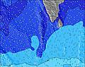 | 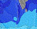 | 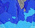 | 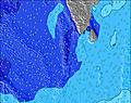 | 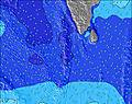 | 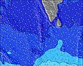 | ||||||||||||
Wave Height (m) Direction Period (s) | W 10 | W 11 | W 7 | SSW 17 | SSW 16 | SSW 16 | SSW 15 | SSW 15 | SSW 19 | SSW 18 | SSW 17 | SSW 16 | SSW 16 | S 18 | S 14 | S 17 | S 16 | S 15 | S 16 |
Wave Graph | |||||||||||||||||||
682 | 716 | 413 | 534 | 561 | 813 | 596 | 666 | 959 | 817 | 1244 | 893 | 730 | 431 | 802 | 839 | 1029 | 581 | 724 | |
Wind (km/h) | |||||||||||||||||||
Wind State on-shore cross-onshore cross-shore cross-offshore off-shore glassy | cross | cross | cross-off | cross-off | cross-off | cross-off | cross-off | cross-off | cross-off | cross | cross | cross | cross | cross | cross-off | cross | cross | cross | cross |
High Tide | 4:54AM0.52m | 4:46PM0.49m | 5:24AM0.51m | 5:13PM0.44m | 5:58AM0.49m | 5:39PM0.39m | 6:40AM0.45m | 6:06PM0.33m | 7:44AM0.41m | 6:33PM0.27m | 10:22AM0.39m | 00:30AM0.27m | |||||||
Low Tide | 10:36PM0.00m | 10:54AM0.09m | 11:00PM0.02m | 11:28AM0.12m | 11:25PM0.05m | 12:06PM0.16m | 11:51PM0.09m | 12:58PM0.21m | 00:21AM0.14m | 2:59PM0.26m | 1:08AM0.20m | 7:02PM0.21m | 5:06AM0.22m | ||||||
— | 6:03 | — | — | 6:03 | — | — | 6:03 | — | — | 6:03 | — | — | 6:03 | — | — | 6:03 | — | — | |
— | — | 6:24 | — | — | 6:24 | — | — | 6:24 | — | — | 6:24 | — | — | 6:23 | — | — | 6:23 | — | |
mm | 9 | 10 | 5 | 1 | — | 1 | 1 | 2 | 2 | 9 | 2 | 4 | 7 | 5 | 7 | 10 | 4 | 5 | 9 |
Temp °C | 26 | 25 | 25 | 26 | 27 | 28 | 27 | 28 | 28 | 27 | 27 | 27 | 26 | 27 | 27 | 26 | 27 | 27 | 26 |
Feels °C | 26 | 25 | 23 | 25 | 26 | 27 | 27 | 28 | 27 | 28 | 27 | 27 | 26 | 27 | 27 | 26 | 27 | 27 | 25 |
Swell 1 Height (m) Direction Period (s) | SSW 8 | S 8 | SSW 14 | SSW 17 | SSW 16 | SSW 16 | SSW 15 | SSW 15 | SSW 19 | SSW 18 | SSW 17 | SSW 16 | SSW 16 | S 14 | S 14 | S 12 | S 16 | S 11 | S 10 |
120 | 149 | 366 | 534 | 561 | 813 | 596 | 666 | 959 | 817 | 1244 | 893 | 730 | 423 | 802 | 690 | 1029 | 382 | 313 | |
Swell 2 Height (m) Direction Period (s) | SSW 14 | SSW 16 | S 8 | W 10 | W 10 | S 8 | S 21 | SSW 21 | SSW 14 | SSW 15 | S 10 | S 10 | S 10 | S 11 | S 18 | S 17 | S 11 | S 15 | S 16 |
210 | 575 | 98 | 186 | 145 | 29 | 216 | 566 | 443 | 413 | 87 | 90 | 177 | 231 | 527 | 839 | 396 | 581 | 724 | |
Swell 3 Height (m) Direction Period (s) | SSW 17 | SSW 20 | SSW 19 | S 8 | SSW 13 | S 24 | S 8 | S 14 | SSE 7 | S 10 | — | — | S 20 | S 18 | — | — | — | S 18 | — |
286 | 75 | 280 | 42 | 133 | 44 | 22 | 4 | 10 | 90 | — | — | 198 | 431 | — | — | — | 307 | — | |
Wind waves Height (m) Direction Period (s) | W 10 | W 11 | W 7 | W 7 | W 7 | W 9 | W 8 | W 8 | W 8 | WSW 7 | WSW 7 | WSW 7 | WSW 7 | WSW 7 | WSW 7 | WSW 7 | W 8 | W 7 | W 8 |
682 | 716 | 413 | 264 | 179 | 372 | 341 | 387 | 397 | 319 | 335 | 382 | 365 | 327 | 383 | 293 | 292 | 262 | 377 | |
Nearest Offshore or Glassy | |||||||||||||||||||
Distance (km) | 371 | 192 | 190 | 17 | 145 | 145 | 145 | 145 | 145 | 192 | 184 | 187 | 192 | 184 | 1205 | 192 | 192 | 192 | 192 |
Best forecast wave conditions in West Sri Lanka | |||||||||||||||||||
Best forecast wave conditions in Sri Lanka | |||||||||||||||||||
Header Global | |||||||||||||||||||
- Map Icons:
 Break
Break Live Wave Height (m)
 Live Wind Speed (km/h)
 Surf Rating (10 Max)
 Ocean Swells (m)
- Wind Speed (km/h)
Latest Updates


FREE! Surf-Forecast.com widget for your website
The surf report / weather widget below is available to embed on third party websites free of charge and provides a summary of our Midigama Left surf forecast. Simply grab the html code snippet that we provide and paste it into your own site. You can choose your preferred language and metric/imperial units for the surf forecast feed to suit users of your site. Click here to get the code.
Information about the Midigama Left Surf forecast
The above surf forecast table for Midigama Left provides essential information for determining whether the surfing conditions will be good over the next 16 days. A general guide to surfing at Midigama Left can be found by selecting the local surf guide option on the grey menu. Our Midigama Left surf forecast is unique since it includes wave energy (power) that defines the real feel of the surf rather than just the height or the period. If you surf the same spot (Midigama Left) regularly then make a mental note of the wave energy from the surf forecast table each time you go. Very soon you may start to choose your surf days based on the wave energy alone combined with our forecast of favourable offshore wind conditions. Our star ratings will help here and of course you will also find the usual wave height and period predictions on our surf forecasts as well as a full break down of the swell components under our advanced users option (to reveal that, click the little Einstein character under the tide times).
Further information to help with frequently asked questions about our surf forecast for Midigama Left may be found under the help tab on the top menu and also by moving your mouse over the question marks on the surf forecast table itself. Please always bear in mind that the forecast is for near-shore open water and local factors at each surf break influence the actual breaking wave height, such as the beach / reef profile, water depths offshore and shelter.
 Nearest