

Surf Forecasts:

Dumbea Left surf forecast from 1 Aug 2026:
- Best quality surf: Saturday 8 Aug, 2AM (local time) - 3.5ft (1.0m), 8s period, ESE swell with offshore winds.
- Most powerful swell: Monday 3 Aug, 2AM (local time) - 10ft (3.0m), 13s period, S swell with 2,894 kJ wave energy.
- Next surfable swell (1★+): Friday 7 Aug, 11PM (local time) - 2.5ft (0.8m), 8s period with ESE swell.
Best Forecast Surf Conditions for Dumbea Left this week:
The surf forecast for Dumbea Left over the next 16 days: The first swell (rated 1 star or higher) is forecast to arrive on Friday (Aug 07) at 11PM. The primary swell is predicted to be 0.8m and 8s period with a secondary swell of 0.5m and 11s. The wind is predicted to be cross-offshore as the swell arrives.
The most powerful waves expected at Dumbea Left in the next 16 days are 3.0m 13s and forecast to arrive on Monday (Aug 03) at 2AM. Winds are predicted to be cross-offshore at the time the swell arrives. The largest open ocean swell (not directed at the beach) is 1.6m 8s period and expected on Friday (Aug 07) at 8AM.
| Wave Type | Time (+11) & Date | Wave Height & Period |
|---|---|---|
| Next good surf (1 star+) | 11PM (Fri 7th Aug) | 2.5ft (0.8m) 8s |
| Best Surf | 2AM (Sat 8th Aug) | 3.5ft (1.0m) 8s |
| Most Powerful | 2AM (Mon 3rd Aug) | 10ft (3.0m) 13s |
Table - best surf conditions forecast for Dumbea Left over the next 16 days.
The Lowdown
Alright, Rusty here. Let's get into it.
First off, we're looking at a pretty flat and messy start for the next few days, no doubt about it. The water temp is sitting right around 73°F which is bang on normal for this time of year, so you won't need any extra rubber.
The real story is a big pulse of south swell that arrives on Sunday the 2nd. This is the standout window. On Sunday morning, we're looking at a solid 10ft S swell with a 12-second period, and the wind is clean cross-off from the ESE, so the faces will be tidy. The combined energy is very strong (2787), so there's plenty of grunt. This is a good one for advanced surfers, because 10ft is getting into that expert-only zone. This swell hangs around through Monday morning with 8ft S swell and clean cross-off wind, but the afternoon gets messy with rain and strong breeze.
After that, the swell drops and we get a long stretch of small, weak surf from the 4th to the 7th. The energy drops right off, and the period is short, so it's not really worth paddling out for.
Now, there's a promising little window on the 8th and 9th. On Saturday the 8th, we get a small 3ft to 4ft ESE swell, but the wind goes glassy on the afternoon, and the water will be like a mirror. That's a rare treat, even if it's small. The energy is still low (351), but it's clean. The same goes for Sunday the 9th with a glassy morning. Good for a longboard or a fun board.
Further out, on the 13th of August, Thursday morning looks glassy again with a 4ft SSE swell, but the energy is only moderate (411). It's worth a look if you're desperate for a clean little wave.
The last real standout is on the 16th of August, Sunday morning. The swell jumps back up to 6ft SSW with a solid 11-second period, and the energy is strong (1320). The wind is light cross-on, but it won't be too bad. The afternoon bumps up to 6ft, also with good energy. This is a decent option for the second week, but it's a long way out, so keep an eye on it.
So, to sum it up: Sunday morning the 2nd is the clear winner for size and power, but it's strictly for the experienced crew. If you want something smaller and cleaner, the glassy mornings on the 8th, 9th, and 13th are your best bet.
Rusty.
Short Range ForecastLight rain (total 3mm), mostly falling on Mon afternoon. Warm (max 20°C on Sat afternoon, min 18°C on Sat night). Mainly strong winds. | Days 5-7 Weather SummaryMostly dry. Warm (max 21°C on Thu afternoon, min 18°C on Tue night). Mainly fresh winds. | |||||||||||||||||||
Sat 1 | Sunday 2 | Monday 3 | Tuesday 4 | Wednesday 5 | Thursday 6 | Friday 7 | ||||||||||||||
PM | Night | AM | PM | Night | AM | PM | Night | AM | PM | Night | AM | PM | Night | AM | PM | Night | AM | PM | Night | |
Swell Height Map |  | 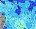 | 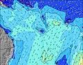 | 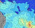 | 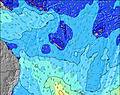 | 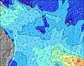 | 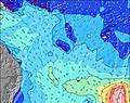 | |||||||||||||
Wave Height (m) Direction Period (s) | SSW 14 | S 12 | S 12 | S 11 | S 13 | S 12 | SSE 12 | SE 9 | SSW 18 | SSW 17 | SSW 16 | SSW 16 | SSW 15 | SSW 14 | ESE 8 | ESE 8 | ESE 7 | ESE 8 | ESE 8 | ESE 8 |
Wave Graph | ||||||||||||||||||||
465 | 2314 | 2648 | 2166 | 2894 | 2070 | 2100 | 878 | 959 | 932 | 651 | 627 | 434 | 325 | 247 | 199 | 131 | 163 | 145 | 122 | |
Wind (km/h) | ||||||||||||||||||||
Wind State on-shore cross-onshore cross-shore cross-offshore off-shore glassy | cross-on | cross-on | cross-off | cross | cross-off | cross-off | cross-off | cross-off | cross-off | cross-off | cross-off | cross-off | cross-off | cross-off | cross-off | cross-off | cross-off | cross-off | cross-off | off |
High Tide | 10:06PM1.34m | 10:05AM1.08m | 10:35PM1.32m | 10:46AM1.07m | 11:06PM1.28m | 11:31AM1.06m | 11:39PM1.22m | 12:24PM1.03m | 00:17AM1.14m | 1:30PM1.01m | 1:04AM1.05m | 2:54PM1.01m | 2:08AM0.96m | |||||||
Low Tide | 4:24AM0.30m | 4:07PM0.17m | 4:58AM0.27m | 4:44PM0.25m | 5:33AM0.25m | 5:24PM0.34m | 6:13AM0.24m | 6:12PM0.44m | 7:01AM0.25m | 7:13PM0.54m | 7:58AM0.25m | 8:38PM0.62m | ||||||||
— | — | 6:28 | — | — | 6:26 | — | — | 6:26 | — | — | 6:26 | — | — | 6:26 | — | — | 6:24 | — | — | |
5:34 | — | — | 5:34 | — | — | 5:35 | — | — | 5:35 | — | — | 5:35 | — | — | 5:36 | — | — | 5:36 | — | |
mm | — | — | — | — | — | — | 1 | 2 | — | — | — | — | — | — | — | — | — | — | — | — |
Temp °C | 20 | 20 | 18 | 19 | 19 | 20 | 19 | 19 | 19 | 20 | 19 | 20 | 20 | 19 | 20 | 21 | 20 | 21 | 22 | 21 |
Feels °C | 14 | 13 | 12 | 12 | 11 | 14 | 13 | 12 | 13 | 14 | 13 | 15 | 14 | 14 | 16 | 15 | 14 | 19 | 18 | 19 |
Swell 1 Height (m) Direction Period (s) | SSW 11 | E 15 | S 12 | S 11 | S 13 | S 12 | SSW 21 | S 10 | SSW 18 | SSW 17 | SSW 16 | SSW 16 | SSW 15 | SSW 14 | SSW 13 | SSW 13 | ESE 7 | S 12 | S 12 | ESE 8 |
317 | 4 | 2648 | 2166 | 2894 | 2070 | 302 | 486 | 959 | 932 | 651 | 627 | 434 | 325 | 201 | 131 | 131 | 47 | 44 | 122 | |
Swell 2 Height (m) Direction Period (s) | SSW 14 | S 23 | SE 11 | S 16 | SE 13 | SE 12 | SE 13 | SSW 20 | SSW 10 | S 10 | S 9 | S 17 | SSW 9 | S 8 | SW 18 | S 16 | S 14 | SW 12 | SSW 12 | SSW 11 |
465 | 11 | 121 | 305 | 132 | 90 | 104 | 776 | 177 | 67 | 41 | 5 | 7 | 5 | 12 | 19 | 99 | 36 | 56 | 105 | |
Swell 3 Height (m) Direction Period (s) | SE 12 | S 23 | SW 21 | SE 11 | SSW 20 | SE 15 | — | SE 13 | — | E 13 | S 9 | E 16 | SSE 12 | E 15 | SE 14 | SE 16 | SSW 13 | SSE 12 | SSE 11 | SE 9 |
190 | 11 | 18 | 123 | 37 | 60 | — | 7 | — | 3 | 38 | 5 | 14 | 4 | 7 | 10 | 65 | 13 | 11 | 23 | |
Wind waves Height (m) Direction Period (s) | S 7 | S 12 | — | — | — | — | SSE 12 | SE 9 | SE 10 | SE 10 | SE 9 | SE 8 | ESE 8 | ESE 8 | ESE 8 | ESE 8 | NE 4 | ESE 8 | ESE 8 | — |
262 | 2314 | — | — | — | — | 2100 | 878 | 865 | 742 | 418 | 355 | 285 | 224 | 247 | 199 | 7 | 163 | 145 | — | |
Nearest Offshore or Glassy | ||||||||||||||||||||
Distance (km) | 1299 | 1247 | 1293 | 1384 | 1403 | 118 | 1384 | 1285 | 1242 | 1299 | 48 | 48 | 50 | 48 | 70 | 118 | 48 | 70 | 70 | 0 |
Best forecast wave conditions in New Caledonia | ||||||||||||||||||||
Best forecast wave conditions in New Caledonia | ||||||||||||||||||||
Header Global | ||||||||||||||||||||
- Map Icons:
 Break
Break Live Wave Height (m)
 Live Wind Speed (km/h)
 Surf Rating (10 Max)
 Ocean Swells (m)
- Wind Speed (km/h)
Latest Updates


FREE! Surf-Forecast.com widget for your website
The surf report / weather widget below is available to embed on third party websites free of charge and provides a summary of our Dumbea Left surf forecast. Simply grab the html code snippet that we provide and paste it into your own site. You can choose your preferred language and metric/imperial units for the surf forecast feed to suit users of your site. Click here to get the code.
Information about the Dumbea Left Surf forecast
The above surf forecast table for Dumbea Left provides essential information for determining whether the surfing conditions will be good over the next 16 days. A general guide to surfing at Dumbea Left can be found by selecting the local surf guide option on the grey menu. Our Dumbea Left surf forecast is unique since it includes wave energy (power) that defines the real feel of the surf rather than just the height or the period. If you surf the same spot (Dumbea Left) regularly then make a mental note of the wave energy from the surf forecast table each time you go. Very soon you may start to choose your surf days based on the wave energy alone combined with our forecast of favourable offshore wind conditions. Our star ratings will help here and of course you will also find the usual wave height and period predictions on our surf forecasts as well as a full break down of the swell components under our advanced users option (to reveal that, click the little Einstein character under the tide times).
Further information to help with frequently asked questions about our surf forecast for Dumbea Left may be found under the help tab on the top menu and also by moving your mouse over the question marks on the surf forecast table itself. Please always bear in mind that the forecast is for near-shore open water and local factors at each surf break influence the actual breaking wave height, such as the beach / reef profile, water depths offshore and shelter.
Dumbea Left is 21 km (13 miles) from Noumea. If you plan a holiday in New Caledonia, look for hotels and other accommodation in Noumea. Noumea has rooms for a wide range of budgets as well as car hire and transport links.
 Nearest