

Surf Forecasts:

Dumbea Rights surf forecast from 2 Aug 2026:
- Best quality surf: Saturday 8 Aug, 2AM (local time) - 6ft (1.8m), 9s period, ESE swell with offshore winds.
- Most powerful swell: Monday 3 Aug, 8AM (local time) - 10ft (3.0m), 13s period, S swell with 2,875 kJ wave energy.
- Next surfable swell (1★+): Saturday 8 Aug, 2AM (local time) - 6ft (1.8m), 9s period with ESE swell.
Best Forecast Surf Conditions for Dumbea Rights this week:
The surf forecast for Dumbea Rights over the next 16 days: The first swell (rated 1 star or higher) is forecast to arrive on Saturday (Aug 08) at 2AM. The primary swell is predicted to be 1.8m and 9s period with a secondary swell of 0.4m and 11s. The wind is predicted to be offshore as the swell arrives.
The most powerful waves expected at Dumbea Rights in the next 16 days are 3.0m 13s and forecast to arrive on Monday (Aug 03) at 8AM. Winds are predicted to be cross-offshore at the time the swell arrives. The largest open ocean swell (not directed at the beach) is 1.8m 9s period and expected on Saturday (Aug 08) at 11AM.
| Wave Type | Time (+11) & Date | Wave Height & Period |
|---|---|---|
| Next good surf (1 star+) | 2AM (Sat 8th Aug) | 6ft (1.8m) 9s |
| Best Surf | 2AM (Sat 8th Aug) | 6ft (1.8m) 9s |
| Most Powerful | 8AM (Mon 3rd Aug) | 10ft (3.0m) 13s |
Table - best surf conditions forecast for Dumbea Rights over the next 16 days.
The Lowdown
Alright mate, let’s have a look at what’s on the cards for this stretch of coast. It’s a bit of a mixed bag, so don’t get too amped for a clean run of pumping surf. We’ve got a solid window of waves, but the wind is gonna be the main player, and it’s not always gonna be on our side.
We’re looking at a period that kicks off with some decent, punchy swell, but the early sessions are gonna be a bit rough around the edges. The conditions are going to clean up for a brief moment in the middle, promising a standout day, but then it looks like things are going to fade out into a bit of a patchy, quiet spell later on.
The first couple of days, Monday the 3rd and Tuesday the 4th, see some solid swell in the 10ft range rolling in from the south with a long period. The energy in the water is strong, with the combined swell energy values well into the four digits, hit 2384 on Monday morning. But here’s the catch – that wind is a fresh cross-off breeze blowing at 22-25 mph. It’s keeping the surf clean, but it’s going to be bumpy and contest-y. This is proper advanced territory; anything over 8ft is expert-only in my book, so the rest of you are better off watching from the sand. The swell does drop back to a more manageable 4ft on Tuesday, but the wind stays up, so it’s still going to be a bit of a wrestle with the elements.
Then things get interesting. The swell eases a bit but the wind goes light. On Saturday morning, the 8th, we’ve got 5ft of ESE groundswell, but the cross-off breeze drops to just 3 mph. That’s the one to get excited about. It’s still got that long period, but it’s clean and glassy. The energy is moderate, at 334, but the lack of wind is going to make it look way better than the numbers suggest. That’s your standout window. The crowd factor is a bit of a thing there, too, so you might have to share.
After that, it goes a bit quiet. Sunday the 9th is mushy and small, with cross-on winds messing things up. The following week, things get properly poor. From the 10th through to the 15th, it’s looking like a write-off. Swell drops off, wind is all over the place, either onshore or cross-onshore, and the energy is low. There’s a brief pulse of energy on the 14th, with a 3ft SSW swell arriving with an 18-second period, but the wind is just hopeless. The breaks will be closed out and messy. It’s a real lull and there’s not much to get excited about. It just looks like a lot of groveling or sitting on the beach.
We do see a bit of life return on Sunday the 16th. The swell bumps up to 5ft from the SSW with a solid 13-second period. The energy rises too, getting close to 1000. But that onshore wind comes straight back with it, and it’s looking cross-shore and lumpy. It’s a promising sign of things to come, though. The long range forecast is hinting at a more substantial SSW swell moving in on Tuesday the 18th, around 8ft. That’s one to keep an eye on, but it’s far out, so I wouldn’t be betting the farm on it just yet. The conditions look like they’re going to be a bit cleaner, which could be a great session if it all lines up, but we’ll see.
Alright, that’s the story. Keep your eyes on Saturday the 8th for the clean one.
Rusty.
Short Range ForecastLight rain (total 4mm), mostly falling on Mon afternoon. Warm (max 20°C on Sun night, min 18°C on Tue night). Mainly strong winds. | Days 5-7 Weather SummaryMostly dry. Warm (max 22°C on Thu afternoon, min 19°C on Wed night). Winds decreasing (fresh winds from the E on Wed night, light winds from the ENE by Sat morning). | ||||||||||||||||||
Monday 3 | Tuesday 4 | Wednesday 5 | Thursday 6 | Friday 7 | Saturday 8 | ||||||||||||||
Night | AM | PM | Night | AM | PM | Night | AM | PM | Night | AM | PM | Night | AM | PM | Night | AM | PM | Night | |
Swell Height Map |  | 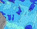 | 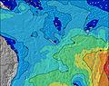 | 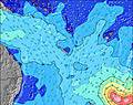 | 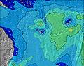 | 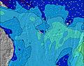 | 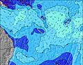 | ||||||||||||
Wave Height (m) Direction Period (s) | S 13 | S 12 | SSE 11 | SE 9 | SSW 18 | SSW 17 | SSW 16 | SSW 16 | SE 8 | SSW 14 | SSW 13 | ESE 7 | ESE 8 | ESE 9 | ESE 9 | ESE 9 | ESE 9 | ESE 9 | ESE 8 |
Wave Graph | |||||||||||||||||||
2891 | 2259 | 2152 | 828 | 948 | 932 | 761 | 627 | 428 | 334 | 220 | 237 | 250 | 440 | 1097 | 537 | 295 | 243 | 180 | |
Wind (km/h) | |||||||||||||||||||
Wind State on-shore cross-onshore cross-shore cross-offshore off-shore glassy | cross | cross-off | cross-off | cross-off | cross-off | cross-off | cross-off | cross-off | cross-off | cross-off | cross-off | cross-off | cross-off | cross-off | cross-off | off | cross-off | cross-on | cross-off |
High Tide | 10:35PM1.32m | 10:46AM1.07m | 11:06PM1.28m | 11:31AM1.06m | 11:39PM1.22m | 12:24PM1.03m | 00:17AM1.14m | 1:30PM1.01m | 1:04AM1.05m | 2:54PM1.01m | 2:08AM0.96m | 4:27PM1.06m | 3:34AM0.91m | ||||||
Low Tide | 4:58AM0.27m | 4:44PM0.25m | 5:33AM0.25m | 5:24PM0.34m | 6:13AM0.24m | 6:12PM0.44m | 7:01AM0.25m | 7:13PM0.54m | 7:58AM0.25m | 8:38PM0.62m | 9:09AM0.25m | 10:24PM0.64m | |||||||
— | 6:26 | — | — | 6:26 | — | — | 6:26 | — | — | 6:26 | — | — | 6:24 | — | — | 6:24 | — | — | |
— | — | 5:35 | — | — | 5:35 | — | — | 5:35 | — | — | 5:36 | — | — | 5:36 | — | — | 5:36 | — | |
mm | — | — | 1 | 2 | — | — | — | 1 | — | — | — | — | — | — | — | — | — | — | — |
Temp °C | 20 | 20 | 19 | 20 | 20 | 20 | 19 | 19 | 20 | 20 | 21 | 22 | 20 | 21 | 22 | 21 | 21 | 22 | 22 |
Feels °C | 13 | 14 | 12 | 13 | 14 | 14 | 13 | 14 | 13 | 13 | 16 | 16 | 15 | 15 | 16 | 16 | 22 | 22 | 22 |
Swell 1 Height (m) Direction Period (s) | S 13 | S 12 | SSW 21 | S 10 | SSW 18 | SSW 17 | SSW 16 | SSW 16 | SSW 15 | SSW 14 | SSW 13 | SSW 13 | S 11 | ESE 9 | ESE 9 | ESE 9 | ESE 9 | ESE 9 | ESE 8 |
2891 | 2259 | 302 | 432 | 948 | 932 | 761 | 627 | 428 | 325 | 201 | 131 | 39 | 440 | 687 | 537 | 295 | 243 | 180 | |
Swell 2 Height (m) Direction Period (s) | SE 13 | SE 12 | E 14 | SSW 20 | SSW 10 | S 10 | SSW 9 | SSW 16 | S 9 | S 8 | SSW 18 | S 16 | SSW 13 | S 12 | SSW 12 | SSW 11 | SE 10 | SE 10 | SSW 10 |
132 | 65 | 4 | 776 | 180 | 92 | 28 | 627 | 2 | 5 | 30 | 19 | 64 | 80 | 47 | 40 | 17 | 16 | 69 | |
Swell 3 Height (m) Direction Period (s) | SSW 20 | SE 15 | — | SE 14 | — | E 13 | SSW 9 | E 12 | SE 13 | E 15 | S 16 | S 13 | S 14 | SW 12 | SSW 12 | SSW 18 | SSW 15 | SW 14 | SW 13 |
37 | 60 | — | 32 | — | 3 | 28 | 3 | 6 | 4 | 21 | 14 | 37 | 35 | 27 | 30 | 22 | 49 | 44 | |
Wind waves Height (m) Direction Period (s) | — | — | SSE 11 | SE 9 | SE 10 | SE 10 | SE 9 | SE 8 | SE 8 | ESE 7 | ESE 7 | ESE 7 | ESE 8 | ENE 4 | ESE 9 | NE 4 | E 9 | E 9 | E 8 |
— | — | 2152 | 828 | 847 | 673 | 514 | 373 | 427 | 334 | 220 | 237 | 250 | 25 | 1097 | 14 | 493 | 390 | 360 | |
Nearest Offshore or Glassy | |||||||||||||||||||
Distance (km) | 1403 | 1394 | 1384 | 759 | 1247 | 1384 | 46 | 68 | 76 | 46 | 46 | 46 | 46 | 48 | 48 | 0 | 0 | 26 | 0 |
Best forecast wave conditions in New Caledonia | |||||||||||||||||||
Best forecast wave conditions in New Caledonia | |||||||||||||||||||
Header Global | |||||||||||||||||||
- Map Icons:
 Break
Break Live Wave Height (m)
 Live Wind Speed (km/h)
 Surf Rating (10 Max)
 Ocean Swells (m)
- Wind Speed (km/h)
Latest Updates


FREE! Surf-Forecast.com widget for your website
The surf report / weather widget below is available to embed on third party websites free of charge and provides a summary of our Dumbea Rights surf forecast. Simply grab the html code snippet that we provide and paste it into your own site. You can choose your preferred language and metric/imperial units for the surf forecast feed to suit users of your site. Click here to get the code.
Information about the Dumbea Rights Surf forecast
The above surf forecast table for Dumbea Rights provides essential information for determining whether the surfing conditions will be good over the next 16 days. A general guide to surfing at Dumbea Rights can be found by selecting the local surf guide option on the grey menu. Our Dumbea Rights surf forecast is unique since it includes wave energy (power) that defines the real feel of the surf rather than just the height or the period. If you surf the same spot (Dumbea Rights) regularly then make a mental note of the wave energy from the surf forecast table each time you go. Very soon you may start to choose your surf days based on the wave energy alone combined with our forecast of favourable offshore wind conditions. Our star ratings will help here and of course you will also find the usual wave height and period predictions on our surf forecasts as well as a full break down of the swell components under our advanced users option (to reveal that, click the little Einstein character under the tide times).
Further information to help with frequently asked questions about our surf forecast for Dumbea Rights may be found under the help tab on the top menu and also by moving your mouse over the question marks on the surf forecast table itself. Please always bear in mind that the forecast is for near-shore open water and local factors at each surf break influence the actual breaking wave height, such as the beach / reef profile, water depths offshore and shelter.
Dumbea Rights is 21 km (13 miles) from Noumea. If you plan a holiday in New Caledonia, look for hotels and other accommodation in Noumea. Noumea has rooms for a wide range of budgets as well as car hire and transport links.
 Nearest