

Surf Forecasts:

Dondra surf forecast from 3 Aug 2026:
- Most powerful swell: Friday 7 Aug, 11PM (local time) - 6ft (1.9m), 17s period, S swell with 2,117 kJ wave energy.
Best Forecast Surf Conditions for Dondra this week:
The most powerful waves expected at Dondra in the next 16 days are 1.9m 17s and forecast to arrive on Friday (Aug 07) at 11PM. Winds are predicted to be cross-offshore at the time the swell arrives.
| Wave Type | Time (+0530) & Date | Wave Height & Period |
|---|---|---|
| Next good surf (1 star+) | - | - |
| Best Surf | - | - |
| Most Powerful | 11PM (Fri 7th Aug) | 6ft (1.9m) 17s |
Table - best surf conditions forecast for Dondra over the next 16 days.
The Lowdown
Alright folks, Rusty here. Let’s have a look at what’s coming up for Dondra.
It’s a bit of a mixed bag ahead, with a long stretch of marginal surf. The swell is inconsistent and the conditions are often tricky, so you’ll need to be patient. The main event looks like it arrives in the second week.
We start off with a bit of a wait, but the first real pulse of interest shows up on Monday the 3rd of August. The afternoon sees a 7ft swell from the west, with an 11-second period. The combined energy is a solid 1637 – that’s moderate wave energy. The wind is a cross-off from the west at 16 mph, which keeps the surface clean. The water is sitting at 83°, which is about average for this time of year. Dondra is a reef break, and it’s inconsistent, so don’t expect a constant stream of waves. The crowds are sometimes a factor. The recommended swell direction is from the southwest, and this westerly swell is a little off that, so it’s not the best alignment.
The surf stays in the 5ft to 6ft range through the rest of the first week, with periods hitting 15 seconds and longer. The energy stays moderate, with the combined energy figures sitting between 1424 and 2024. The wind remains a consistent cross-off from the west or west-northwest, keeping things clean. However, the forecast is littered with notes of risk of thunderstorms, especially from the 5th through the 9th. The swell direction shifts to the south and south-southwest, which is a much better match for the optimum southwest direction. The waves are there, but the quality is described as marginal, and the scores are low. It’s a tough one to call.
A real standout arrives on Tuesday the 18th of August. We get a solid 8ft swell from the south-southwest, with a very long period of 19 seconds. That’s proper groundswell. The combined energy jumps to 5110, which is strong to very strong wave energy. The wind is a clean 16 mph cross-off from the west. For Dondra, a reef break, this is a prime setup. The long period will offer some real power, but it might make the wave a bit too lined up for a beach break. Still, at Dondra, this is the best on offer. Because the swell is over 8ft, this is strictly for experienced surfers. The morning of the 18th is also solid, with a 7ft swell from the south, with an 18-second period and a combined energy of 3744.
The second week sees a definite drop in energy. The combined energy figures fall to between 344 and 1623. Swell heights drop to between 2ft and 4ft, with long periods still present. The wind stays cross-off, but the surf becomes much smaller and less consistent. The 15th and 16th of August look particularly weak, with very little to work with.
So, the call is clear: the moment to get excited about is the 18th of August. That south-southwest groundswell with the long period and clean wind will be the best of the window. The earlier part of the period has waves, but the quality is marginal and the conditions are a bit messy. Be patient, and aim for that final Tuesday.
Rusty.
Short Range ForecastModerate rain (total 16mm), heaviest on Wed morning. Warm (max 29°C on Tue afternoon, min 25°C on Mon night). Mainly fresh winds. | Days 5-7 Weather SummaryHeavy rain (total 29mm), heaviest during Thu night. Warm (max 28°C on Fri morning, min 26°C on Thu afternoon). Mainly fresh winds. | |||||||||||||||||||
Mon 3 | Tuesday 4 | Wednesday 5 | Thursday 6 | Friday 7 | Saturday 8 | Sunday 9 | ||||||||||||||
PM | Night | AM | PM | Night | AM | PM | Night | AM | PM | Night | AM | PM | Night | AM | PM | Night | AM | PM | Night | |
Swell Height Map |  | 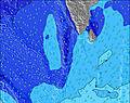 | 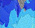 | 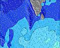 | 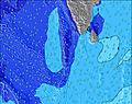 | 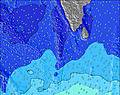 |  | |||||||||||||
Wave Height (m) Direction Period (s) | W 11 | SSW 17 | SSW 16 | SSW 16 | SSW 15 | SSW 15 | SSW 19 | SSW 18 | SSW 17 | SSW 16 | S 16 | S 14 | S 14 | S 17 | S 16 | S 15 | S 16 | S 14 | S 17 | S 16 |
Wave Graph | ||||||||||||||||||||
883 | 1003 | 998 | 974 | 736 | 845 | 959 | 1929 | 1450 | 1531 | 1248 | 931 | 918 | 946 | 1855 | 1327 | 1402 | 865 | 1929 | 734 | |
Wind (km/h) | ||||||||||||||||||||
Wind State on-shore cross-onshore cross-shore cross-offshore off-shore glassy | cross-off | cross-off | cross-off | cross-off | cross-off | cross-off | cross-off | cross-off | cross-off | cross-off | cross-off | cross-off | cross-off | cross-off | cross-off | cross-off | cross-off | cross-off | cross-off | cross-off |
High Tide | 4:47PM0.48m | 5:25AM0.51m | 5:14PM0.44m | 5:59AM0.48m | 5:40PM0.38m | 6:40AM0.45m | 6:07PM0.33m | 7:44AM0.41m | 6:31PM0.27m | 10:23AM0.39m | 00:37AM0.27m | 12:23PM0.42m | 1:23AM0.33m | |||||||
Low Tide | 11:01PM0.03m | 11:29AM0.13m | 11:25PM0.06m | 12:08PM0.17m | 11:52PM0.10m | 12:59PM0.21m | 00:21AM0.15m | 3:03PM0.26m | 1:06AM0.20m | 7:02PM0.21m | 5:11AM0.23m | 7:28PM0.15m | ||||||||
— | — | 6:01 | — | — | 6:01 | — | — | 6:01 | — | — | 6:01 | — | — | 6:01 | — | — | 6:01 | — | — | |
6:23 | — | — | 6:23 | — | — | 6:23 | — | — | 6:23 | — | — | 6:22 | — | — | 6:22 | — | — | 6:22 | — | |
mm | 2 | 1 | — | — | 3 | 3 | 3 | 3 | 1 | 2 | 5 | 2 | 2 | 5 | 2 | 2 | 5 | 4 | 2 | 3 |
Temp °C | 26 | 26 | 28 | 29 | 27 | 27 | 27 | 26 | 28 | 27 | 26 | 28 | 28 | 26 | 28 | 28 | 26 | 27 | 27 | 26 |
Feels °C | 25 | 26 | 26 | 28 | 28 | 28 | 27 | 26 | 27 | 27 | 26 | 28 | 27 | 26 | 27 | 27 | 26 | 27 | 27 | 26 |
Swell 1 Height (m) Direction Period (s) | SSW 14 | SSW 17 | SSW 16 | SSW 16 | SSW 15 | SSW 15 | SSW 15 | SSW 18 | SSW 17 | SSW 16 | S 16 | S 14 | S 14 | S 17 | S 16 | S 15 | S 16 | S 14 | S 17 | S 12 |
394 | 1003 | 998 | 974 | 736 | 845 | 580 | 1929 | 1450 | 1531 | 1248 | 931 | 918 | 946 | 1855 | 1327 | 1402 | 865 | 1929 | 380 | |
Swell 2 Height (m) Direction Period (s) | S 8 | S 8 | S 7 | S 7 | S 8 | SSW 21 | SSW 19 | — | S 10 | — | S 20 | S 18 | S 18 | S 13 | — | S 18 | S 19 | S 17 | SSW 26 | S 16 |
80 | 42 | 40 | 39 | 33 | 566 | 959 | — | 146 | — | 190 | 670 | 635 | 538 | — | 224 | 109 | 454 | 66 | 734 | |
Swell 3 Height (m) Direction Period (s) | SSW 19 | SE 9 | SE 8 | S 24 | SSW 22 | S 14 | W 11 | — | — | — | S 20 | — | — | W 14 | — | S 18 | — | S 28 | SSW 26 | SSE 11 |
280 | 3 | 3 | 11 | 156 | 4 | 64 | — | — | — | 190 | — | — | 4 | — | 224 | — | 16 | 66 | 47 | |
Wind waves Height (m) Direction Period (s) | W 11 | W 10 | W 10 | W 10 | W 9 | W 6 | W 7 | W 7 | W 7 | W 7 | W 7 | W 7 | W 7 | W 7 | WSW 7 | WSW 7 | W 7 | W 6 | W 6 | W 6 |
883 | 580 | 431 | 400 | 416 | 291 | 328 | 392 | 428 | 493 | 465 | 399 | 366 | 366 | 350 | 342 | 408 | 255 | 219 | 255 | |
Nearest Offshore or Glassy | ||||||||||||||||||||
Distance (km) | 174 | 41 | 125 | 41 | 175 | 125 | 139 | 175 | 167 | 167 | 175 | 167 | 2006 | 175 | 167 | 746 | 175 | 175 | 175 | 175 |
Best forecast wave conditions in West Sri Lanka | ||||||||||||||||||||
Best forecast wave conditions in Sri Lanka | ||||||||||||||||||||
Header Global | ||||||||||||||||||||
- Map Icons:
 Break
Break Live Wave Height (m)
 Live Wind Speed (km/h)
 Surf Rating (10 Max)
 Ocean Swells (m)
- Wind Speed (km/h)
Latest Updates


FREE! Surf-Forecast.com widget for your website
The surf report / weather widget below is available to embed on third party websites free of charge and provides a summary of our Dondra surf forecast. Simply grab the html code snippet that we provide and paste it into your own site. You can choose your preferred language and metric/imperial units for the surf forecast feed to suit users of your site. Click here to get the code.
Information about the Dondra Surf forecast
The above surf forecast table for Dondra provides essential information for determining whether the surfing conditions will be good over the next 16 days. A general guide to surfing at Dondra can be found by selecting the local surf guide option on the grey menu. Our Dondra surf forecast is unique since it includes wave energy (power) that defines the real feel of the surf rather than just the height or the period. If you surf the same spot (Dondra) regularly then make a mental note of the wave energy from the surf forecast table each time you go. Very soon you may start to choose your surf days based on the wave energy alone combined with our forecast of favourable offshore wind conditions. Our star ratings will help here and of course you will also find the usual wave height and period predictions on our surf forecasts as well as a full break down of the swell components under our advanced users option (to reveal that, click the little Einstein character under the tide times).
Further information to help with frequently asked questions about our surf forecast for Dondra may be found under the help tab on the top menu and also by moving your mouse over the question marks on the surf forecast table itself. Please always bear in mind that the forecast is for near-shore open water and local factors at each surf break influence the actual breaking wave height, such as the beach / reef profile, water depths offshore and shelter.
Dondra is 8 km (5 miles) from Matara. If you plan a holiday in West Sri Lanka, look for hotels and other accommodation in Matara. Matara has rooms for a wide range of budgets as well as car hire and transport links.
 Nearest