

Surf Forecasts:

Costa del Sol surf forecast from 2 Aug 2026:
- Best quality surf: Friday 7 Aug, 6PM (local time) - 2.5ft (0.8m), 17s period, SSW swell with glassy winds.
- Most powerful swell: Saturday 8 Aug, 9AM (local time) - 3.5ft (1.0m), 16s period, SSW swell with 532 kJ wave energy.
- Next surfable swell (1★+): Sunday 2 Aug, 12AM (local time) - 2.5ft (0.8m), 12s period with SSW swell.
Best Forecast Surf Conditions for Costa del Sol this week:
The surf forecast for Costa del Sol over the next 16 days: The first swell (rated 1 star or higher) is forecast to arrive on Sunday (Aug 02) at 12AM. The primary swell is predicted to be 0.8m and 12s period with a secondary swell of 0.4m and 6s. Another secondary swell of 0.3m and 3s is also forecast. The wind is predicted to be cross-offshore as the swell arrives.
The most powerful waves expected at Costa del Sol in the next 16 days are 1.0m 16s and forecast to arrive on Saturday (Aug 08) at 9AM. Winds are predicted to be cross-offshore at the time the swell arrives. The largest open ocean swell (not directed at the beach) is 0.4m 3s period and expected on Wednesday (Aug 05) at 3AM.
| Wave Type | Time (CST) & Date | Wave Height & Period |
|---|---|---|
| Next good surf (1 star+) | 12AM (Sun 2nd Aug) | 2.5ft (0.8m) 12s |
| Best Surf | 6PM (Fri 7th Aug) | 2.5ft (0.8m) 17s |
| Most Powerful | 9AM (Sat 8th Aug) | 3.5ft (1.0m) 16s |
Table - best surf conditions forecast for Costa del Sol over the next 16 days.
The Lowdown
Alright, Rusty here again, but this time in feet and knots for those who think in those numbers.
There’s a quiet start to the outlook, so don’t rush down to the beach just yet. We’re looking at a few days with nothing to ride before the surf starts showing up.
For the Costa del Sol, the water is sitting at a warm 31°, which is a touch warmer than usual for this time of year – nice for a long session in boardshorts.
The first real chance to paddle out comes Sunday morning August 2nd. We’ve got a small 2ft SSW swell, but the wind is glassy with a light 3 mph NE breeze. The combined energy is moderate at 249, so it’ll be clean but weak. This spot is good for beginners, but it can be inconsistent, and crowds are only sometimes an issue.
Monday morning the 3rd is almost a carbon copy: glassy, no wind, and a touch bigger at 3ft from the SSW (energy 356). Clean but small.
The standout window comes on Saturday August 8th. Morning swell hits 3ft from the SSW with a 16-second period – that’s a long-period groundswell with real grunt. The wind is a light 6 mph NE cross-off, keeping the surface clean. Combined energy is a strong 723, so these waves will have some push. The afternoon stays glassy with the same size and energy of 559. That Saturday is the pick of the entire outlook.
Sunday the 9th holds similar size at 3ft, but the wind stays cross-off in the morning before turning onshore in the afternoon. Stick to the early sessions.
Looking into the second week, Saturday August 15th is another date to mark. A 4ft SW swell with a 16-second period, clean offshore NE wind, and strong energy at 755. That’s your best late-period call – powerful groundswell and clean conditions.
Remember, the mornings are your friend. The aftertons nearly always get messy with onshore SW wind. The biggest highlights are Saturday the 8th and August 15th. The rest of the run stays small but rideable.
Rusty out.
Short Range ForecastHeavy rain (total 20mm), heaviest during Mon night. Warm (max 32°C on Sat afternoon, min 24°C on Mon night). Wind will be generally light. | Days 5-7 Weather SummaryModerate rain (total 13mm), heaviest on Thu night. Warm (max 31°C on Wed morning, min 25°C on Tue night). Wind will be generally light. | |||||||||||||||||||
Sat 1 | Sunday 2 | Monday 3 | Tuesday 4 | Wednesday 5 | Thursday 6 | Friday 7 | ||||||||||||||
PM | Night | AM | PM | Night | AM | PM | Night | AM | PM | Night | AM | PM | Night | AM | PM | Night | AM | PM | Night | |
Swell Height Map |  |  |  | 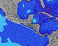 | 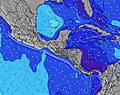 | 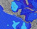 | 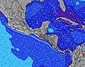 | |||||||||||||
Wave Height (m) Direction Period (s) | SSW 13 | SSW 12 | SSW 12 | SSW 14 | SSW 14 | SSW 14 | SSW 13 | SSW 13 | SSW 13 | SW 12 | SSW 12 | S 8 | SW 15 | SSW 14 | SSW 14 | SSW 14 | SSW 18 | SSW 18 | SSW 18 | SSW 16 |
Wave Graph | ||||||||||||||||||||
212 | 193 | 125 | 140 | 253 | 286 | 273 | 151 | 109 | 74 | 98 | 82 | 57 | 82 | 131 | 121 | 221 | 209 | 390 | 330 | |
Wind (km/h) | ||||||||||||||||||||
Wind State on-shore cross-onshore cross-shore cross-offshore off-shore glassy | on | cross-off | glassy | on | cross-off | glassy | on | off | off | on | off | off | on | cross-off | cross-off | on | glassy | off | on | cross-off |
High Tide | 4:40PM2.07m | 5:08AM2.10m | 5:17PM2.03m | 5:44AM2.14m | 5:55PM1.97m | 6:22AM2.16m | 6:36PM1.90m | 7:03AM2.15m | 7:21PM1.83m | 7:51AM2.14m | 8:14PM1.75m | 8:46AM2.11m | 9:15PM1.70m | |||||||
Low Tide | 10:53PM0.24m | 11:14AM0.37m | 11:26PM0.25m | 11:54AM0.36m | 00:02AM0.28m | 12:37PM0.37m | 00:41AM0.31m | 1:24PM0.39m | 1:25AM0.36m | 2:17PM0.42m | 2:16AM0.40m | 3:18PM0.45m | ||||||||
— | — | 5:39 | — | — | 5:41 | — | — | 5:41 | — | — | 5:41 | — | — | 5:41 | — | — | 5:41 | — | — | |
6:22 | — | — | 6:22 | — | — | 6:22 | — | — | 6:22 | — | — | 6:21 | — | — | 6:21 | — | — | 6:20 | — | |
mm | — | — | — | — | 5 | — | — | 13 | 2 | — | 3 | — | — | 2 | — | 1 | 7 | — | — | 2 |
Temp °C | 32 | 28 | 30 | 31 | 28 | 31 | 31 | 27 | 31 | 30 | 25 | 31 | 30 | 28 | 31 | 30 | 27 | 31 | 29 | 28 |
Feels °C | 33 | 31 | 30 | 32 | 31 | 33 | 33 | 30 | 33 | 32 | 28 | 32 | 32 | 31 | 32 | 32 | 31 | 32 | 32 | 32 |
Swell 1 Height (m) Direction Period (s) | SSW 13 | SSW 12 | SSW 12 | SSW 12 | SSW 14 | SSW 14 | SSW 13 | S 8 | SSW 8 | S 8 | S 8 | S 8 | S 8 | S 8 | S 8 | SSW 14 | SW 13 | SSE 8 | SSW 18 | SSW 16 |
212 | 193 | 125 | 90 | 253 | 286 | 273 | 60 | 79 | 63 | 78 | 82 | 57 | 61 | 46 | 121 | 183 | 105 | 390 | 330 | |
Swell 2 Height (m) Direction Period (s) | SW 16 | SE 6 | SW 15 | SSW 14 | SE 6 | SSW 18 | SW 16 | SSW 13 | SSW 13 | SW 12 | SSW 12 | SW 12 | SW 12 | SSW 14 | SSW 14 | S 8 | S 8 | SW 13 | SW 13 | SW 12 |
41 | 9 | 106 | 140 | 8 | 61 | 68 | 151 | 109 | 74 | 98 | 71 | 35 | 82 | 131 | 43 | 46 | 175 | 134 | 149 | |
Swell 3 Height (m) Direction Period (s) | SSW 19 | SSW 16 | SSE 7 | SSE 7 | S 7 | S 11 | SE 7 | SW 16 | SW 16 | SSW 10 | W 8 | SW 15 | SW 15 | SW 11 | SW 11 | SE 6 | SSW 18 | SSW 18 | S 12 | SSE 7 |
37 | 25 | 18 | 32 | 9 | 9 | 2 | 67 | 65 | 40 | 1 | 55 | 55 | 19 | 19 | 10 | 221 | 209 | 103 | 40 | |
Wind waves Height (m) Direction Period (s) | SSE 7 | WNW 3 | — | SSW 3 | W 3 | — | SW 3 | — | ENE 2 | SSW 3 | WNW 3 | NNE 2 | SSW 3 | — | NNE 3 | S 3 | — | — | SSE 7 | ESE 6 |
66 | 1 | — | 2 | 1 | — | 4 | — | 1 | 2 | 1 | 1 | 4 | — | 1 | 5 | — | — | 29 | 40 | |
Nearest Offshore or Glassy | ||||||||||||||||||||
Distance (km) | 187 | 0 | 0 | 289 | 0 | 0 | 435 | 0 | 0 | 205 | 0 | 0 | 289 | 0 | 0 | 423 | 0 | 0 | 184 | 0 |
Best forecast wave conditions in El-Salvador - Costa del Balsamo | ||||||||||||||||||||
Best forecast wave conditions in El Salvador | ||||||||||||||||||||
Header Global | ||||||||||||||||||||
- Map Icons:
 Break
Break Live Wave Height (m)
 Live Wind Speed (km/h)
 Surf Rating (10 Max)
 Ocean Swells (m)
- Wind Speed (km/h)
Latest Updates


FREE! Surf-Forecast.com widget for your website
The surf report / weather widget below is available to embed on third party websites free of charge and provides a summary of our Costa del Sol surf forecast. Simply grab the html code snippet that we provide and paste it into your own site. You can choose your preferred language and metric/imperial units for the surf forecast feed to suit users of your site. Click here to get the code.
Information about the Costa del Sol Surf forecast
The above surf forecast table for Costa del Sol provides essential information for determining whether the surfing conditions will be good over the next 16 days. A general guide to surfing at Costa del Sol can be found by selecting the local surf guide option on the grey menu. Our Costa del Sol surf forecast is unique since it includes wave energy (power) that defines the real feel of the surf rather than just the height or the period. If you surf the same spot (Costa del Sol) regularly then make a mental note of the wave energy from the surf forecast table each time you go. Very soon you may start to choose your surf days based on the wave energy alone combined with our forecast of favourable offshore wind conditions. Our star ratings will help here and of course you will also find the usual wave height and period predictions on our surf forecasts as well as a full break down of the swell components under our advanced users option (to reveal that, click the little Einstein character under the tide times).
Further information to help with frequently asked questions about our surf forecast for Costa del Sol may be found under the help tab on the top menu and also by moving your mouse over the question marks on the surf forecast table itself. Please always bear in mind that the forecast is for near-shore open water and local factors at each surf break influence the actual breaking wave height, such as the beach / reef profile, water depths offshore and shelter.
Are you planning a holiday in El-Salvador - Costa del Balsamo? If you are looking for accommodation near Costa del Sol, camping, hotels and holiday cottages in El-Salvador - Costa del Balsamo, consider staying in Zacatecoluca which is 23 km (14 miles) away. Other places in and around El-Salvador - Costa del Balsamo where you can find information about places to rent, and car hire include San Vicente which is 39 km (24 miles) away, Puerto El Triunfo, Cojutepeque and La Libertad.
 Nearest