

Surf Forecasts:

Alykes - Zakynthos surf forecast from 2 Aug 2026:
- Most powerful swell: Thursday 6 Aug, 12AM (local time) - 1.5ft (0.4m), 4s period, NNW swell with 5 kJ wave energy.
Best Forecast Surf Conditions for Alykes - Zakynthos this week:
The most powerful waves expected at Alykes - Zakynthos in the next 16 days are 0.4m 4s and forecast to arrive on Thursday (Aug 06) at 12AM. Winds are predicted to be cross-shore at the time the swell arrives. The largest open ocean swell (not directed at the beach) is 0.6m 4s period and expected on Sunday (Aug 09) at 6PM.
| Wave Type | Time (EEST) & Date | Wave Height & Period |
|---|---|---|
| Next good surf (1 star+) | - | - |
| Best Surf | - | - |
| Most Powerful | 12AM (Thu 6th Aug) | 1.5ft (0.4m) 4s |
Table - best surf conditions forecast for Alykes - Zakynthos over the next 16 days.
The Lowdown
G'day, this is Rusty. Let me tell you straight up—there's nothing on the cards for the next 16 days at Alykes. This is a real quiet stretch. The surf forecast is a total blank: no decent swell, no rideable waves, and the combined energy of all swells directed here sits at a flat 0, which is as weak as it gets. Don't expect any size on the horizon.
The first morning of the forecast, August 3rd, has glassy conditions with a light NE wind at 3 mph, but there's no swell to speak of. That pattern just keeps repeating itself: glassy mornings, a few cross-off afternoons, and not a single wave worth paddling for. Even the mornings with calm, glassy conditions on August 6th, 13th, and 15th show only tiny ripples of 0.7 ft to 1 ft from the north or northeast, with periods of 2 to 3 seconds—that's just wind chop, not surf.
The water temperature is about average for the time of year, no real anomaly there. But with zero swell energy and a sea like a lake, you're better off with a stand-up paddleboard or a kayak. This spot is inconsistent at the best of times, and this run is a classic example of what happens when the weather just sits still.
It's a long gap—the whole 16-day window—with no real surf on offer. That can happen in these parts. Keep an eye on the charts, because forecasts can change, but for now, there's nothing to get excited about.
Rusty
Short Range ForecastMostly dry. Warm (max 30°C on Wed afternoon, min 24°C on Sun night). Wind will be generally light. | Days 5-7 Weather SummaryMostly dry. Warm (max 29°C on Wed night, min 25°C on Thu night). Wind will be generally light. | ||||||||||||||||||
Monday 3 | Tuesday 4 | Wednesday 5 | Thursday 6 | Friday 7 | Saturday 8 | ||||||||||||||
Night | AM | PM | Night | AM | PM | Night | AM | PM | Night | AM | PM | Night | AM | PM | Night | AM | PM | Night | |
Swell Height Map | 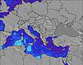 | 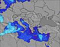 | 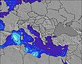 | 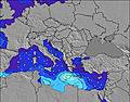 | 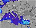 | 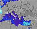 | 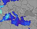 | ||||||||||||
Wave Height (m) Direction Period (s) | — | — | — | — | — | — | W 3 | W 3 | W 3 | NNW 3 | N 3 | WNW 4 | WNW 3 | WSW 4 | W 3 | WNW 4 | WNW 4 | WNW 4 | WNW 4 |
Wave Graph | |||||||||||||||||||
0 | 0 | 0 | 0 | 0 | 0 | 0 | 0 | 0 | 2 | 1 | 0 | 0 | 0 | 0 | 0 | 0 | 0 | 0 | |
Wind (km/h) | |||||||||||||||||||
Wind State on-shore cross-onshore cross-shore cross-offshore off-shore glassy | glassy | glassy | cross-off | cross-on | glassy | cross-off | cross | glassy | cross-off | cross | glassy | cross-off | on | glassy | cross-off | cross-on | cross-on | cross-off | cross |
High Tide | 7:37AM0.13m | 7:26PM0.13m | 8:18AM0.13m | 8:06PM0.11m | 9:11AM0.13m | 9:08PM0.09m | 10:34AM0.12m | 11:24PM0.08m | 12:25PM0.13m | 1:42AM0.09m | 1:43PM0.14m | 2:47AM0.10m | |||||||
Low Tide | 1:25AM0.01m | 1:44PM0.04m | 1:57AM0.02m | 2:36PM0.05m | 2:34AM0.03m | 3:47PM0.06m | 3:23AM0.04m | 5:39PM0.06m | 4:44AM0.05m | 7:47PM0.05m | 6:44AM0.06m | 8:51PM0.03m | |||||||
— | 6:41 | — | — | 6:41 | — | — | 6:43 | — | — | 6:43 | — | — | 6:43 | — | — | 6:45 | — | — | |
8:45 | — | 8:44 | — | — | 8:43 | — | — | 8:42 | — | — | 8:40 | — | — | 8:39 | — | — | 8:38 | — | |
mm | — | — | — | — | — | — | — | — | — | — | — | — | — | — | — | — | — | — | — |
Temp °C | 27 | 28 | 29 | 27 | 28 | 28 | 28 | 29 | 30 | 29 | 29 | 29 | 27 | 28 | 29 | 28 | 29 | 29 | 27 |
Feels °C | 28 | 29 | 27 | 30 | 30 | 28 | 29 | 31 | 29 | 29 | 31 | 28 | 29 | 29 | 29 | 31 | 31 | 29 | 30 |
Swell 1 Height (m) Direction Period (s) | — | — | — | — | — | — | W 3 | W 3 | — | W 4 | NNW 3 | — | WNW 3 | WSW 4 | — | WNW 4 | WNW 4 | — | WNW 4 |
— | — | — | — | — | — | 1 | 1 | — | 1 | 1 | — | 2 | 2 | — | 2 | 3 | — | 6 | |
Swell 2 Height (m) Direction Period (s) | — | — | — | — | — | — | — | — | — | — | W 4 | — | — | — | — | — | — | — | SW 4 |
— | — | — | — | — | — | — | — | — | — | 1 | — | — | — | — | — | — | — | 1 | |
Swell 3 Height (m) Direction Period (s) | — | — | — | — | — | — | — | — | — | — | — | — | — | — | — | — | — | — | — |
— | — | — | — | — | — | — | — | — | — | — | — | — | — | — | — | — | — | — | |
Wind waves Height (m) Direction Period (s) | — | — | — | — | — | — | — | — | W 3 | NNW 3 | N 3 | WNW 4 | — | — | W 3 | — | — | WNW 4 | — |
— | — | — | — | — | — | — | — | 2 | 2 | 1 | 3 | — | — | 1 | — | — | 3 | — | |
Nearest Offshore or Glassy | |||||||||||||||||||
Distance (km) | 2007 | 1972 | 2251 | 1972 | 2069 | 2226 | 1972 | 1972 | 2175 | 1097 | 961 | 2066 | 504 | 1089 | 2066 | 1089 | 1053 | 2347 | 1127 |
Best forecast wave conditions in Ionian Sea | |||||||||||||||||||
Best forecast wave conditions in Greece | |||||||||||||||||||
Header Global | |||||||||||||||||||
- Map Icons:
 Break
Break Live Wave Height (m)
 Live Wind Speed (km/h)
 Surf Rating (10 Max)
 Ocean Swells (m)
- Wind Speed (km/h)
Latest Updates


FREE! Surf-Forecast.com widget for your website
The surf report / weather widget below is available to embed on third party websites free of charge and provides a summary of our Alykes - Zakynthos surf forecast. Simply grab the html code snippet that we provide and paste it into your own site. You can choose your preferred language and metric/imperial units for the surf forecast feed to suit users of your site. Click here to get the code.
Information about the Alykes - Zakynthos Surf forecast
The above surf forecast table for Alykes - Zakynthos provides essential information for determining whether the surfing conditions will be good over the next 16 days. A general guide to surfing at Alykes - Zakynthos can be found by selecting the local surf guide option on the grey menu. Our Alykes - Zakynthos surf forecast is unique since it includes wave energy (power) that defines the real feel of the surf rather than just the height or the period. If you surf the same spot (Alykes - Zakynthos) regularly then make a mental note of the wave energy from the surf forecast table each time you go. Very soon you may start to choose your surf days based on the wave energy alone combined with our forecast of favourable offshore wind conditions. Our star ratings will help here and of course you will also find the usual wave height and period predictions on our surf forecasts as well as a full break down of the swell components under our advanced users option (to reveal that, click the little Einstein character under the tide times).
Further information to help with frequently asked questions about our surf forecast for Alykes - Zakynthos may be found under the help tab on the top menu and also by moving your mouse over the question marks on the surf forecast table itself. Please always bear in mind that the forecast is for near-shore open water and local factors at each surf break influence the actual breaking wave height, such as the beach / reef profile, water depths offshore and shelter.
 Nearest