

Surf Forecasts:

Short Range ForecastMostly dry. Warm (max 29°C on Tue morning, min 24°C on Mon night). Wind will be generally light. | ||||||||||||||||||||||
Monday 3 | Tuesday 4 | Wednesday 5 | ||||||||||||||||||||
6 AM | 9 AM | 12 PM | 3 PM | 6 PM | 9 PM | 12 AM | 3 AM | 6 AM | 9 AM | 12 PM | 3 PM | 6 PM | 9 PM | 12 AM | 3 AM | 6 AM | 9 AM | 12 PM | 3 PM | 6 PM | 9 PM | |
Swell Height Map | 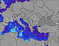 | 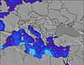 | 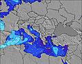 | 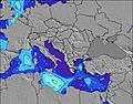 | 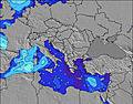 | 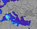 | 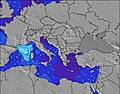 | 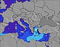 | ||||||||||||||
Wave Height (m) Direction Period (s) | — | — | — | — | — | — | — | — | — | — | NW 2 | WNW 3 | NW 3 | NW 3 | NW 3 | WNW 4 | WNW 3 | WNW 3 | WNW 3 | WNW 3 | WNW 4 | W 4 |
Wave Graph | ||||||||||||||||||||||
0 | 0 | 0 | 0 | 0 | 0 | 0 | 0 | 0 | 0 | 1 | 4 | 3 | 3 | 4 | 2 | 2 | 1 | 1 | 3 | 5 | 8 | |
Wind (km/h) | ||||||||||||||||||||||
Wind State on-shore cross-onshore cross-shore cross-offshore off-shore glassy | cross | cross-on | cross-on | cross-on | cross-on | glassy | glassy | cross-on | cross-on | cross-on | on | cross-on | on | glassy | on | cross-on | cross-on | cross-on | on | on | on | on |
High Tide | 7:21AM0.11m | 7:06PM0.11m | 8:01AM0.11m | 7:47PM0.09m | 8:57AM0.11m | 8:48PM0.08m | ||||||||||||||||
Low Tide | 1:16PM0.04m | 1:28AM0.02m | 2:11PM0.05m | 2:03AM0.03m | 3:25PM0.05m | |||||||||||||||||
6:39 | — | — | — | — | — | — | — | 6:39 | — | — | — | — | — | — | — | 6:41 | — | — | — | — | — | |
— | — | — | — | 8:38 | — | — | — | — | — | — | — | 8:37 | — | — | — | — | — | — | — | 8:37 | — | |
mm | — | — | — | — | — | — | — | — | — | — | — | — | — | — | — | — | — | — | — | — | — | — |
Temp °C | 24 | 26 | 28 | 27 | 27 | 26 | 26 | 25 | 24 | 27 | 29 | 28 | 28 | 26 | 26 | 25 | 25 | 27 | 29 | 29 | 28 | 28 |
Feels °C | 24 | 26 | 27 | 26 | 28 | 29 | 28 | 25 | 24 | 27 | 27 | 29 | 30 | 29 | 28 | 27 | 26 | 27 | 29 | 30 | 31 | 30 |
Swell 1 Height (m) Direction Period (s) | — | — | — | — | — | — | — | — | — | — | — | — | — | — | WNW 4 | — | — | — | — | — | — | — |
— | — | — | — | — | — | — | — | — | — | — | — | — | — | 2 | — | — | — | — | — | — | — | |
Swell 2 Height (m) Direction Period (s) | — | — | — | — | — | — | — | — | — | — | — | — | — | — | — | — | — | — | — | — | — | — |
— | — | — | — | — | — | — | — | — | — | — | — | — | — | — | — | — | — | — | — | — | — | |
Swell 3 Height (m) Direction Period (s) | — | — | — | — | — | — | — | — | — | — | — | — | — | — | — | — | — | — | — | — | — | — |
— | — | — | — | — | — | — | — | — | — | — | — | — | — | — | — | — | — | — | — | — | — | |
Wind waves Height (m) Direction Period (s) | — | — | — | — | — | — | — | — | — | — | NW 2 | WNW 3 | NW 3 | NW 3 | NW 3 | WNW 4 | WNW 3 | WNW 3 | WNW 3 | WNW 3 | WNW 4 | W 4 |
— | — | — | — | — | — | — | — | — | — | 1 | 4 | 3 | 3 | 4 | 2 | 2 | 1 | 1 | 3 | 5 | 8 | |
Nearest Offshore or Glassy | ||||||||||||||||||||||
Distance (km) | 2070 | 2070 | 2075 | 2427 | 2561 | 2507 | 2070 | 2069 | 2070 | 2070 | 2070 | 2416 | 2416 | 2421 | 1098 | 2069 | 1007 | 2069 | 2069 | 2431 | 2271 | 2170 |
Best forecast wave conditions in Pelloponisos | ||||||||||||||||||||||
Best forecast wave conditions in Greece | ||||||||||||||||||||||
Header Global | ||||||||||||||||||||||
- Map Icons:
 Break
Break Live Wave Height (m)
 Live Wind Speed (km/h)
 Surf Rating (10 Max)
 Ocean Swells (m)
- Wind Speed (km/h)
Latest Updates


FREE! Surf-Forecast.com widget for your website
The surf report / weather widget below is available to embed on third party websites free of charge and provides a summary of our Agrili surf forecast. Simply grab the html code snippet that we provide and paste it into your own site. You can choose your preferred language and metric/imperial units for the surf forecast feed to suit users of your site. Click here to get the code.
 Nearest