

Surf Forecasts:

How big are the waves at Weligama today (03 Aug):
- Morning surf: Morning surf (03 Aug, local time) - 5ft (1.6m), 11s period with W swell.
- Afternoon surf: Afternoon surf (03 Aug, local time) - 3.5ft (1.0m), 15s period with SSW swell.
- Evening surf: Evening surf (03 Aug, local time) - 3ft (0.9m), 15s period with SSW swell.
The current surf forecast for Weligama at 10AM is: 1.7m 11s primary swell from a West direction and 1.1m 16s secondary swell from a South-southwest direction, 1.0m 8s secondary swell from a South direction (forecast issued at 04:30am August 03). The wind direction is predicted to be cross-shore.
| Time (+0530) & Date | Wave Height | Wave Period |
|---|---|---|
| Morning (03 Aug) | 5ft (1.6m) | 11s |
| Afternoon (03 Aug) | 3.5ft (1.0m) | 15s |
| Evening (03 Aug) | 3ft (0.9m) | 15s |
Table - waves today at Weligama. (Swell directed towards the surf break)
Short Range ForecastModerate rain (total 16mm), heaviest on Mon morning. Warm (max 28°C on Wed morning, min 26°C on Mon morning). Mainly fresh winds. | ||||||||||||||||||||||||
Monday 3 | Tuesday 4 | Wednesday 5 | ||||||||||||||||||||||
2 AM | 5 AM | 8 AM | 11 AM | 2 PM | 5 PM | 8 PM | 11 PM | 2 AM | 5 AM | 8 AM | 11 AM | 2 PM | 5 PM | 8 PM | 11 PM | 2 AM | 5 AM | 8 AM | 11 AM | 2 PM | 5 PM | 8 PM | 11 PM | |
Swell Height Map |  | 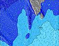 | 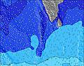 | 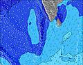 | 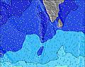 | 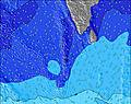 | 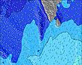 | 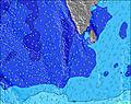 | 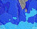 | |||||||||||||||
Wave Height (m) Direction Period (s) | W 10 | W 10 | W 10 | W 11 | SSW 15 | W 7 | W 7 | SSW 18 | SSW 17 | SSW 17 | W 10 | W 10 | SSW 16 | SSW 16 | SSW 16 | SSW 15 | SSW 15 | SSW 15 | SSW 15 | SSW 15 | SSW 20 | SSW 19 | SSW 19 | S 19 |
Wave Graph | ||||||||||||||||||||||||
676 | 1152 | 553 | 639 | 525 | 392 | 401 | 823 | 534 | 625 | 568 | 614 | 813 | 813 | 763 | 612 | 596 | 696 | 596 | 666 | 640 | 959 | 796 | 721 | |
Wind (km/h) | ||||||||||||||||||||||||
Wind State on-shore cross-onshore cross-shore cross-offshore off-shore glassy | cross | cross | cross | cross | cross-off | cross-off | cross-off | cross-off | cross-off | cross-off | cross-off | cross-off | cross-off | cross-off | cross-off | cross-off | cross-off | cross-off | cross-off | cross-off | cross-off | cross-off | cross | cross |
High Tide | 4:54AM0.52m | 4:46PM0.49m | 5:24AM0.51m | 5:13PM0.44m | 5:58AM0.49m | 5:39PM0.39m | ||||||||||||||||||
Low Tide | 10:54AM0.09m | 11:00PM0.02m | 11:28AM0.12m | 11:25PM0.05m | 12:06PM0.16m | |||||||||||||||||||
— | 6:03 | — | — | — | — | — | — | — | 6:03 | — | — | — | — | — | — | — | 6:03 | — | — | — | — | — | — | |
— | — | — | — | — | 6:24 | — | — | — | — | — | — | — | 6:24 | — | — | — | — | — | — | — | 6:24 | — | — | |
mm | 2 | 2 | 3 | 2 | 1 | 1 | — | — | — | — | — | — | — | — | — | — | — | 1 | 1 | 1 | — | 1 | 1 | 1 |
Temp °C | 26 | 26 | 26 | 26 | 26 | 26 | 26 | 26 | 26 | 26 | 26 | 27 | 27 | 27 | 26 | 27 | 27 | 27 | 27 | 28 | 28 | 27 | 26 | 26 |
Feels °C | 26 | 26 | 26 | 25 | 24 | 24 | 25 | 26 | 26 | 26 | 26 | 27 | 27 | 27 | 26 | 28 | 27 | 27 | 26 | 27 | 28 | 27 | 26 | 26 |
Swell 1 Height (m) Direction Period (s) | SSW 8 | W 10 | SSW 8 | SSW 16 | SSW 15 | SSW 14 | SSW 15 | SSW 18 | W 7 | SSW 17 | SSW 16 | W 10 | W 9 | SSW 16 | SSW 16 | SSW 15 | SSW 15 | SSW 15 | SSW 15 | SSW 15 | SSW 15 | SSW 19 | SSW 19 | S 19 |
128 | 543 | 163 | 575 | 525 | 366 | 397 | 823 | 214 | 625 | 568 | 414 | 372 | 813 | 763 | 612 | 596 | 696 | 596 | 666 | 551 | 959 | 796 | 721 | |
Swell 2 Height (m) Direction Period (s) | SSW 14 | SSW 8 | SSW 16 | S 8 | SSW 8 | S 8 | S 8 | W 10 | SSW 17 | W 10 | SSW 13 | SSW 16 | SSW 16 | S 7 | S 7 | S 9 | S 21 | S 22 | SSW 21 | SSW 21 | SSW 20 | SSW 14 | SSW 15 | SSW 15 |
210 | 155 | 273 | 127 | 104 | 78 | 60 | 192 | 534 | 154 | 135 | 561 | 813 | 28 | 27 | 39 | 216 | 236 | 359 | 566 | 640 | 443 | 314 | 397 | |
Swell 3 Height (m) Direction Period (s) | SSW 17 | SSW 16 | SSW 13 | SSW 20 | SSW 20 | SSW 19 | SSW 18 | S 8 | W 10 | SSW 13 | S 8 | SSW 13 | S 8 | S 24 | S 24 | SSW 23 | S 7 | — | S 9 | S 14 | — | — | S 11 | S 10 |
286 | 350 | 198 | 75 | 127 | 280 | 254 | 44 | 159 | 135 | 29 | 133 | 41 | 44 | 43 | 104 | 27 | — | 23 | 4 | — | — | 116 | 108 | |
Wind waves Height (m) Direction Period (s) | W 10 | W 10 | W 10 | W 11 | W 6 | W 7 | W 7 | W 7 | W 7 | W 7 | W 10 | W 10 | W 9 | W 9 | W 8 | W 8 | W 8 | W 8 | W 8 | W 8 | W 8 | W 8 | W 8 | WSW 7 |
676 | 1152 | 553 | 639 | 321 | 392 | 401 | 236 | 258 | 192 | 470 | 614 | 556 | 348 | 318 | 323 | 359 | 377 | 391 | 424 | 419 | 387 | 367 | 355 | |
Nearest Offshore or Glassy | ||||||||||||||||||||||||
Distance (km) | 379 | 742 | 742 | 189 | 190 | 189 | 671 | 190 | 189 | 142 | 20 | 142 | 142 | 142 | 20 | 142 | 182 | 142 | 182 | 142 | 142 | 1361 | 189 | 190 |
Best forecast wave conditions in West Sri Lanka | ||||||||||||||||||||||||
Best forecast wave conditions in Sri Lanka | ||||||||||||||||||||||||
Header Global | ||||||||||||||||||||||||
- Map Icons:
 Break
Break Live Wave Height (m)
 Live Wind Speed (km/h)
 Surf Rating (10 Max)
 Ocean Swells (m)
- Wind Speed (km/h)
Latest Updates


FREE! Surf-Forecast.com widget for your website
The surf report / weather widget below is available to embed on third party websites free of charge and provides a summary of our Weligama surf forecast. Simply grab the html code snippet that we provide and paste it into your own site. You can choose your preferred language and metric/imperial units for the surf forecast feed to suit users of your site. Click here to get the code.
 Nearest