

Surf Forecasts:

Tenexpa surf forecast from 2 Aug 2026:
- Best quality surf: Friday 7 Aug, 3AM (local time) - 2.5ft (0.7m), 18s period, SSW swell with offshore winds.
- Most powerful swell: Saturday 8 Aug, 12PM (local time) - 4.5ft (1.3m), 15s period, SSW swell with 683 kJ wave energy.
- Next surfable swell (1★+): Sunday 2 Aug, 9PM (local time) - 2ft (0.6m), 13s period with SW swell.
Best Forecast Surf Conditions for Tenexpa this week:
The surf forecast for Tenexpa over the next 16 days: The first swell (rated 1 star or higher) is forecast to arrive on Sunday (Aug 02) at 9PM. The primary swell is predicted to be 0.6m and 13s period with a secondary swell of 0.6m and 12s. The wind is predicted to be cross-offshore as the swell arrives.
The most powerful waves expected at Tenexpa in the next 16 days are 1.3m 15s and forecast to arrive on Saturday (Aug 08) at 12PM. Winds are predicted to be onshore at the time the swell arrives.
| Wave Type | Time (CST) & Date | Wave Height & Period |
|---|---|---|
| Next good surf (1 star+) | 9PM (Sun 2nd Aug) | 2ft (0.6m) 13s |
| Best Surf | 3AM (Fri 7th Aug) | 2.5ft (0.7m) 18s |
| Most Powerful | 12PM (Sat 8th Aug) | 4.5ft (1.3m) 15s |
Table - best surf conditions forecast for Tenexpa over the next 16 days.
The Lowdown
G'day, Rusty here. And I'm stoked to say the next couple of weeks have some real gems on offer for us at Tenexpa. We've got a consistent run of clean mornings coming up, so don't sleep on the early sessions.
The water is sitting at 88°F, which is a touch warmer than average for this time of year, so you can leave the steamer at home. The combined swell energy kicks off at a moderate 281 and builds through the period.
Let's start with this coming Sunday morning, the 2nd of August. There's a risk of thunderstorms, but the wind is a light cross-offshore from the north at 9 mph, keeping it clean. We're looking at a 2 ft SSW groundswell with a nice 12-second period, which is enough to get a few fun ones.
Monday the 3rd is where it starts to cook. The morning is glassy with a light ENE breeze, not a breath of wind on the water. That 3 ft SSW swell is starting to push through with a period of 14 seconds, and the combined energy jumps to a moderate 363. That's a solid session, and it’s going to feel like the swell has some real push.
Tuesday the 4th, another glassy morning with a NNW breeze. The swell drops a touch to 2 ft, but that wind makes it worth the paddle.
The standout run starts on Friday morning, the 7th of August. We get a 3 ft SSW groundswell with a very long 18-second period, and the combined energy surges to 705. The wind is light from the NE, making it glassy. This is groundswell at its finest – long, clean lines, and those long waits between sets will keep the crowd manageable. Expect some excellent shape.
But the real highlight is Saturday the 8th of August. It's an absolute beauty of a morning. Clear skies, no wind at all, dead glassy. The swell is 4 ft from the SSW at 16 seconds, and combined energy hits 742. This is thick, powerful water. If you’re out there at dawn, you’re in for a treat.
It keeps rolling through the next week. Thursday the 13th morning is another glassy one with a 3 ft SW groundswell and 15-second period.
Then we get to the big one – Friday the 14th of August. The morning is glassy with a northerly breeze, and we’ve got a 4 ft SW swell with an 18-second period. Check this: the combined swell energy is a massive 1054 – that’s strong wave energy, real power. This is for experienced surfers only; anything over 8 ft would be too big for beginners, and this is right up there in the expert zone. That long period groundswell will be peeling perfectly down the point, but at a beach break it could close out.
Saturday the 15th is also a beaut morning with a cross-offshore breeze from the NW. Another 4 ft SW swell at 16 seconds, and the energy hits 1086. That's as good as it gets for the period.
The mornings from the 16th and 17th of August still offer clean 3-4 ft SW swells with glassy conditions, though the energy drops back to moderate levels.
One thing to note: Tenexpa can get crowded sometimes, so for those peak sessions on the 8th and 14th, get down early.
Also, be aware that because of the very long periods (over 15 seconds) on the 7th, 11th, 14th, and 15th, those swells will break a bit straighter at the beach breaks but will be absolutely firing off the point and reef setups.
There are no big gaps in the surf here – it’s pretty much consistent good to excellent conditions all the way through.
Stay salty,
Rusty
Short Range ForecastHeavy rain (total 37mm), heaviest during Sun morning. Warm (max 30°C on Sun afternoon, min 25°C on Sun morning). Wind will be generally light. | Days 4-6 Weather SummaryModerate rain (total 19mm), heaviest on Fri night. Warm (max 31°C on Wed morning, min 25°C on Fri night). Wind will be generally light. | ||||||||||||||||||||
Sunday 2 | Monday 3 | Tuesday 4 | Wednesday 5 | Thursday 6 | Friday 7 | Saturday 8 | |||||||||||||||
AM | PM | Night | AM | PM | Night | AM | PM | Night | AM | PM | Night | AM | PM | Night | AM | PM | Night | AM | PM | Night | |
Swell Height Map |  |  |  | 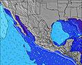 | 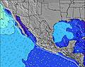 | 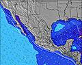 | 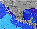 | ||||||||||||||
Wave Height (m) Direction Period (s) | SW 14 | SW 14 | SSW 12 | SSW 14 | SW 13 | SSW 13 | SSW 12 | SSW 12 | SSW 12 | SW 15 | SW 14 | SW 14 | SW 13 | SSW 18 | SSW 18 | SSW 18 | SSW 16 | SSW 16 | SSW 16 | SSW 15 | SSW 14 |
Wave Graph | |||||||||||||||||||||
145 | 147 | 150 | 265 | 162 | 114 | 103 | 98 | 127 | 134 | 130 | 160 | 173 | 214 | 214 | 480 | 559 | 627 | 596 | 665 | 508 | |
Wind (km/h) | |||||||||||||||||||||
Wind State on-shore cross-onshore cross-shore cross-offshore off-shore glassy | cross-off | cross-on | cross-off | glassy | cross-on | cross-off | glassy | cross-off | glassy | glassy | on | off | glassy | cross-on | cross-off | glassy | cross-on | cross-off | glassy | cross-on | cross-off |
High Tide | 6:06PM0.55m | 7:15AM0.58m | 6:31PM0.53m | 7:41AM0.66m | 6:49PM0.51m | 8:08AM0.73m | 7:06PM0.50m | 8:38AM0.79m | 7:26PM0.50m | 9:11AM0.83m | 7:51PM0.52m | 9:47AM0.84m | 8:22PM0.54m | ||||||||
Low Tide | 11:51AM0.37m | 00:28AM0.27m | 12:55PM0.35m | 00:41AM0.22m | 1:41PM0.34m | 00:59AM0.15m | 2:18PM0.33m | 1:22AM0.08m | 2:51PM0.33m | 1:51AM0.01m | 3:23PM0.34m | 2:25AM-0.05m | 3:55PM0.36m | ||||||||
6:22 | — | — | 6:22 | — | — | 6:22 | — | — | 6:22 | — | — | 6:22 | — | — | 6:22 | — | — | 6:22 | — | — | |
— | 7:14 | — | — | 7:14 | — | — | 7:13 | — | — | 7:13 | — | — | 7:12 | — | — | 7:12 | — | — | 7:10 | — | |
mm | 20 | — | — | — | — | 3 | 11 | 3 | — | — | — | 5 | — | — | 1 | — | 1 | 12 | — | — | 2 |
Temp °C | 29 | 30 | 28 | 29 | 30 | 29 | 29 | 28 | 28 | 31 | 31 | 28 | 30 | 31 | 28 | 30 | 30 | 28 | 30 | 30 | 28 |
Feels °C | 33 | 33 | 32 | 34 | 35 | 34 | 31 | 33 | 33 | 35 | 34 | 32 | 33 | 34 | 32 | 33 | 33 | 34 | 33 | 32 | 32 |
Swell 1 Height (m) Direction Period (s) | SSW 12 | SSW 12 | SSW 12 | SSW 14 | SW 13 | SSW 13 | S 8 | SSW 12 | SSW 12 | S 9 | S 9 | S 8 | SW 13 | SW 13 | SW 13 | SSW 18 | SSW 16 | SSW 16 | SSW 16 | SSW 15 | SSW 14 |
145 | 147 | 150 | 265 | 162 | 114 | 45 | 98 | 127 | 57 | 55 | 51 | 173 | 208 | 156 | 480 | 559 | 627 | 596 | 665 | 508 | |
Swell 2 Height (m) Direction Period (s) | SW 14 | SW 14 | SW 13 | SW 13 | SSE 10 | S 8 | SSW 12 | S 8 | S 8 | SW 15 | SW 14 | SW 14 | S 8 | S 8 | SSW 18 | SW 12 | S 8 | SW 12 | SW 12 | S 8 | S 8 |
123 | 114 | 108 | 80 | 31 | 35 | 103 | 46 | 32 | 134 | 130 | 160 | 51 | 51 | 214 | 181 | 58 | 144 | 114 | 46 | 61 | |
Swell 3 Height (m) Direction Period (s) | W 5 | W 6 | W 7 | W 8 | SW 16 | SW 12 | SW 16 | W 5 | SW 15 | SW 12 | SW 11 | SW 20 | SW 20 | SSW 18 | S 8 | S 8 | SW 12 | S 12 | S 8 | SSE 12 | SW 11 |
13 | 15 | 27 | 18 | 67 | 51 | 90 | 4 | 76 | 35 | 33 | 97 | 98 | 214 | 49 | 44 | 118 | 106 | 32 | 26 | 76 | |
Wind waves Height (m) Direction Period (s) | — | — | W 6 | — | W 9 | — | — | — | — | — | — | — | — | — | — | — | — | — | — | — | W 4 |
— | — | 24 | — | 24 | — | — | — | — | — | — | — | — | — | — | — | — | — | — | — | 10 | |
Nearest Offshore or Glassy | |||||||||||||||||||||
Distance (km) | 0 | 660 | 0 | 0 | 1151 | 0 | 0 | 0 | 0 | 0 | 562 | 0 | 0 | 562 | 0 | 0 | 562 | 0 | 0 | 562 | 0 |
Best forecast wave conditions in Guerrero | |||||||||||||||||||||
Best forecast wave conditions in Mexico | |||||||||||||||||||||
Header Global | |||||||||||||||||||||
- Map Icons:
 Break
Break Live Wave Height (m)
 Live Wind Speed (km/h)
 Surf Rating (10 Max)
 Ocean Swells (m)
- Wind Speed (km/h)
Latest Updates


FREE! Surf-Forecast.com widget for your website
The surf report / weather widget below is available to embed on third party websites free of charge and provides a summary of our Tenexpa surf forecast. Simply grab the html code snippet that we provide and paste it into your own site. You can choose your preferred language and metric/imperial units for the surf forecast feed to suit users of your site. Click here to get the code.
Information about the Tenexpa Surf forecast
The above surf forecast table for Tenexpa provides essential information for determining whether the surfing conditions will be good over the next 16 days. A general guide to surfing at Tenexpa can be found by selecting the local surf guide option on the grey menu. Our Tenexpa surf forecast is unique since it includes wave energy (power) that defines the real feel of the surf rather than just the height or the period. If you surf the same spot (Tenexpa) regularly then make a mental note of the wave energy from the surf forecast table each time you go. Very soon you may start to choose your surf days based on the wave energy alone combined with our forecast of favourable offshore wind conditions. Our star ratings will help here and of course you will also find the usual wave height and period predictions on our surf forecasts as well as a full break down of the swell components under our advanced users option (to reveal that, click the little Einstein character under the tide times).
Further information to help with frequently asked questions about our surf forecast for Tenexpa may be found under the help tab on the top menu and also by moving your mouse over the question marks on the surf forecast table itself. Please always bear in mind that the forecast is for near-shore open water and local factors at each surf break influence the actual breaking wave height, such as the beach / reef profile, water depths offshore and shelter.
Tenexpa is 17 km (11 miles) from the city of Atoyac de Alvarez. If you plan a holiday in Guerrero, look for hotels and other accommodation in Atoyac de Alvarez. Atoyac de Alvarez has rooms for a wide range of budgets as well as car hire and transport links.
 Nearest