

Surf Forecasts:

Hikkaduwa (A-Frame) surf forecast from 3 Aug 2026:
- Most powerful swell: Friday 7 Aug, 11PM (local time) - 6ft (1.9m), 17s period, S swell with 2,117 kJ wave energy.
Best Forecast Surf Conditions for Hikkaduwa (A-Frame) this week:
The most powerful waves expected at Hikkaduwa (A-Frame) in the next 16 days are 1.9m 17s and forecast to arrive on Friday (Aug 07) at 11PM. Winds are predicted to be cross-onshore at the time the swell arrives.
| Wave Type | Time (+0530) & Date | Wave Height & Period |
|---|---|---|
| Next good surf (1 star+) | - | - |
| Best Surf | - | - |
| Most Powerful | 11PM (Fri 7th Aug) | 6ft (1.9m) 17s |
Table - best surf conditions forecast for Hikkaduwa (A-Frame) over the next 16 days.
The Lowdown
Alright folks, Rusty here. Let’s have a look at what’s cookin’ for the Hikkaduwa area over the next couple of weeks.
Well, I gotta be straight with you – this is a grim stretch of forecast. The whole 16-day window is a write-off for anything decent. We’re looking at a solid blank run from now through the 18th of August with no real surf on offer. The wind is almost permanently cross-on or onshore, blowing from the west or west-northwest, and it’s bringing in risk of thunderstorms nearly every day. The water is sitting at 84°, which is a touch warmer than normal for this time of year, so that’s fine, but it doesn’t help with the messy ocean.
The one spot we’ve got is Hikkaduwa (A-Frame), a reef break that’s fairly consistent and exposed to the south-west swell. The optimum swell direction is from the SW, which is what we’re seeing, but it’s paired with terrible wind. The swell energy is strong across the board – you’ll see figures like 1753 and 2844 (combined energy of all swells directed here), but it’s all wasted. The waves are lumpy, choppy, and blown out. No clean lines, no glassy windows.
The best the whole period can muster is a couple of afternoon sessions on the 14th and 15th of August, where the forecast only calls it “marginal,” but even then, the wind is still onshore or cross-on, and the swell is a messy 7 ft to 7 ft. For a beginner-friendly spot, that’s a lot of water moving around, and the short period of 7 to 8 seconds means it’s just a jumbled up mess. Not worth paddling out for.
Bottom line: leave the board on the roof. It’s not happening. The monsoon is owning the coast, and we’re just waiting for a change. Forecasts can shift, but right now, there’s nothing to get excited about.
Stay patient,
Rusty
Short Range ForecastHeavy rain (total 30mm), heaviest during Mon morning. Warm (max 27°C on Mon night, min 25°C on Mon morning). Mainly fresh winds. | Days 4-6 Weather SummaryHeavy rain (total 50mm), heaviest during Sat afternoon. Warm (max 27°C on Thu morning, min 26°C on Thu night). Mainly fresh winds. | ||||||||||||||||||||
Monday 3 | Tuesday 4 | Wednesday 5 | Thursday 6 | Friday 7 | Saturday 8 | Sunday 9 | |||||||||||||||
AM | PM | Night | AM | PM | Night | AM | PM | Night | AM | PM | Night | AM | PM | Night | AM | PM | Night | AM | PM | Night | |
Swell Height Map | 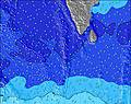 | 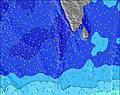 | 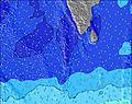 | 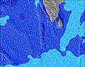 | 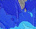 | 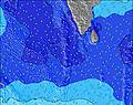 | 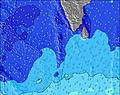 | ||||||||||||||
Wave Height (m) Direction Period (s) | W 11 | W 7 | SSW 17 | SSW 16 | SSW 16 | SSW 15 | SSW 15 | SSW 19 | SSW 18 | SSW 17 | SSW 16 | SSW 16 | S 14 | S 14 | S 17 | S 16 | S 15 | S 16 | S 14 | S 18 | S 16 |
Wave Graph | |||||||||||||||||||||
1010 | 551 | 1003 | 870 | 848 | 736 | 727 | 1011 | 1726 | 1450 | 1531 | 871 | 931 | 918 | 957 | 1667 | 1089 | 1764 | 1002 | 1970 | 752 | |
Wind (km/h) | |||||||||||||||||||||
Wind State on-shore cross-onshore cross-shore cross-offshore off-shore glassy | cross-on | cross-on | cross-on | cross-on | cross-on | cross-on | cross-on | cross-on | cross-on | cross-on | cross-on | cross-on | on | cross-on | cross-on | on | on | cross-on | on | cross-on | cross-on |
High Tide | 4:35PM0.60m | 5:16AM0.61m | 4:59PM0.55m | 5:51AM0.58m | 5:23PM0.48m | 6:34AM0.54m | 5:45PM0.41m | 7:41AM0.49m | 5:52PM0.34m | 10:00AM0.46m | 10:11PM0.27m | 12:05PM0.50m | 00:44AM0.33m | ||||||||
Low Tide | 10:38AM0.14m | 10:51PM0.04m | 11:12AM0.17m | 11:16PM0.07m | 11:50AM0.22m | 11:43PM0.09m | 12:39PM0.27m | 00:14AM0.13m | 2:22PM0.32m | 00:59AM0.18m | 7:37PM0.26m | 3:56AM0.23m | 7:27PM0.20m | ||||||||
6:03 | — | — | 6:03 | — | — | 6:03 | — | — | 6:03 | — | — | 6:03 | — | — | 6:03 | — | — | 6:03 | — | — | |
— | 6:27 | — | — | 6:25 | — | — | 6:25 | — | — | 6:25 | — | — | 6:25 | — | — | 6:24 | — | — | 6:24 | — | |
mm | 8 | 2 | 1 | 1 | 3 | 6 | 2 | 1 | 6 | 2 | 1 | 10 | 4 | 4 | 9 | 3 | 6 | 11 | 5 | 4 | 5 |
Temp °C | 26 | 26 | 27 | 27 | 27 | 27 | 27 | 27 | 27 | 27 | 27 | 27 | 27 | 27 | 27 | 27 | 27 | 26 | 27 | 27 | 26 |
Feels °C | 26 | 24 | 27 | 27 | 26 | 27 | 26 | 26 | 27 | 27 | 26 | 27 | 27 | 26 | 27 | 27 | 26 | 25 | 27 | 27 | 26 |
Swell 1 Height (m) Direction Period (s) | SSW 14 | SSW 15 | SSW 17 | SSW 16 | SSW 16 | SSW 15 | SSW 15 | SSW 19 | SSW 18 | SSW 17 | SSW 16 | SSW 16 | S 14 | S 14 | S 17 | S 16 | S 15 | S 16 | S 14 | S 18 | S 12 |
433 | 551 | 1003 | 870 | 848 | 736 | 726 | 1011 | 1726 | 1450 | 1531 | 871 | 931 | 918 | 957 | 1667 | 1089 | 1764 | 1002 | 1970 | 383 | |
Swell 2 Height (m) Direction Period (s) | S 8 | S 8 | S 8 | S 8 | S 7 | SSW 21 | SSW 20 | SSW 15 | SSW 15 | S 10 | S 10 | S 10 | SSW 18 | S 18 | S 12 | S 11 | S 18 | S 16 | S 17 | SSW 26 | S 16 |
105 | 80 | 43 | 40 | 27 | 244 | 727 | 580 | 413 | 118 | 138 | 212 | 558 | 635 | 518 | 396 | 399 | 715 | 351 | 66 | 752 | |
Swell 3 Height (m) Direction Period (s) | SSW 19 | SSW 19 | W 10 | — | S 24 | S 7 | S 14 | S 7 | S 10 | — | — | S 20 | WNW 11 | — | — | — | S 18 | — | SW 28 | S 18 | SSW 24 |
205 | 207 | 159 | — | 44 | 15 | 4 | 8 | 65 | — | — | 196 | 24 | — | — | — | 307 | — | 31 | 395 | 224 | |
Wind waves Height (m) Direction Period (s) | W 11 | W 7 | W 7 | W 10 | W 8 | W 8 | W 8 | W 8 | W 8 | W 7 | W 7 | W 7 | W 7 | W 7 | W 8 | W 7 | W 7 | W 8 | W 8 | W 8 | W 7 |
1010 | 537 | 445 | 602 | 481 | 535 | 596 | 588 | 549 | 521 | 475 | 461 | 521 | 572 | 553 | 491 | 491 | 470 | 458 | 413 | 374 | |
Nearest Offshore or Glassy | |||||||||||||||||||||
Distance (km) | 210 | 210 | 210 | 170 | 170 | 204 | 170 | 1351 | 211 | 204 | 204 | 211 | 204 | 211 | 211 | 211 | 211 | 211 | 210 | 210 | 211 |
Best forecast wave conditions in West Sri Lanka | |||||||||||||||||||||
Best forecast wave conditions in Sri Lanka | |||||||||||||||||||||
Header Global | |||||||||||||||||||||
- Map Icons:
 Break
Break Live Wave Height (m)
 Live Wind Speed (km/h)
 Surf Rating (10 Max)
 Ocean Swells (m)
- Wind Speed (km/h)
Latest Updates


FREE! Surf-Forecast.com widget for your website
The surf report / weather widget below is available to embed on third party websites free of charge and provides a summary of our Hikkaduwa (A-Frame) surf forecast. Simply grab the html code snippet that we provide and paste it into your own site. You can choose your preferred language and metric/imperial units for the surf forecast feed to suit users of your site. Click here to get the code.
Information about the Hikkaduwa (A-Frame) Surf forecast
The above surf forecast table for Hikkaduwa (A-Frame) provides essential information for determining whether the surfing conditions will be good over the next 16 days. A general guide to surfing at Hikkaduwa (A-Frame) can be found by selecting the local surf guide option on the grey menu. Our Hikkaduwa (A-Frame) surf forecast is unique since it includes wave energy (power) that defines the real feel of the surf rather than just the height or the period. If you surf the same spot (Hikkaduwa (A-Frame)) regularly then make a mental note of the wave energy from the surf forecast table each time you go. Very soon you may start to choose your surf days based on the wave energy alone combined with our forecast of favourable offshore wind conditions. Our star ratings will help here and of course you will also find the usual wave height and period predictions on our surf forecasts as well as a full break down of the swell components under our advanced users option (to reveal that, click the little Einstein character under the tide times).
Further information to help with frequently asked questions about our surf forecast for Hikkaduwa (A-Frame) may be found under the help tab on the top menu and also by moving your mouse over the question marks on the surf forecast table itself. Please always bear in mind that the forecast is for near-shore open water and local factors at each surf break influence the actual breaking wave height, such as the beach / reef profile, water depths offshore and shelter.
 Nearest