

Surf Forecasts:

El Estero surf forecast from 3 Aug 2026:
- Best quality surf: Saturday 8 Aug, 12AM (local time) - 3ft (0.9m), 16s period, SW swell with offshore winds.
- Most powerful swell: Saturday 8 Aug, 9AM (local time) - 3ft (0.9m), 16s period, SSW swell with 441 kJ wave energy.
- Next surfable swell (1★+): Monday 3 Aug, 12PM (local time) - 2.5ft (0.8m), 13s period with SW swell.
Best Forecast Surf Conditions for El Estero this week:
The surf forecast for El Estero over the next 16 days: The first swell (rated 1 star or higher) is forecast to arrive on Monday (Aug 03) at 12PM. The primary swell is predicted to be 0.8m and 13s period. The wind is predicted to be glassy as the swell arrives.
The most powerful waves expected at El Estero in the next 16 days are 0.9m 16s and forecast to arrive on Saturday (Aug 08) at 9AM. Winds are predicted to be offshore at the time the swell arrives. The largest open ocean swell (not directed at the beach) is 0.9m 9s period and expected on Tuesday (Aug 04) at 6AM.
| Wave Type | Time (CST) & Date | Wave Height & Period |
|---|---|---|
| Next good surf (1 star+) | 12PM (Mon 3rd Aug) | 2.5ft (0.8m) 13s |
| Best Surf | 12AM (Sat 8th Aug) | 3ft (0.9m) 16s |
| Most Powerful | 9AM (Sat 8th Aug) | 3ft (0.9m) 16s |
Table - best surf conditions forecast for El Estero over the next 16 days.
The Lowdown
Alright folks, Rusty here. Let’s have a look at what’s comin’ down the pipe for the next couple of weeks.
We’re lookin’ at a run that starts off a bit underwhelming, but man, it builds into some proper action, especially towards the end of the first week and into the second. The main event is definitely El Estero, a consistent river mouth that’s exposed to the west-northwest. The water’s sittin’ at a warm 86°, which is a touch warmer than normal for this time of year, so you can leave the steamer at home.
Monday morning, August 3rd kicks things off with a small but promising pulse. We’ve got a 3ft SW groundswell rollin’ in with a period of 14 seconds, and the wind is glassy out of the ENE at 3 mph. That’s a beautiful start to the day – clean, smooth, and the westerly swell lines are gonna wrap in nicely. The combined energy is moderate at 300. It’s a solid little session for the early birds, but the wind swaps to a westerly onshore in the arvo, so get it while it’s good.
Tuesday the 4th and Wednesday the 5th drop off a bit. Swell sizes dip to 2ft with a shorter period, and while the mornings offer clean, cross-off conditions, the afternoon winds are messy. Not a write-off, but nothin’ special.
Thursday the 6th sees a slight bump back to 2ft, but the real shift happens on Friday morning, August 7th. A new SSW groundswell fills in at 2ft but with a very long period of 18 seconds, and the energy jumps to 377 (moderate). The wind is offshore from the ENE at 6 mph. That’s a clean, lined-up bank setup. That long period from the south-southwest is gonna push some good shape into the river mouth, with longer waits between sets but way more push.
Saturday, August 8th is a standout. The swell builds to 3ft from the SSW, period at 16 seconds, and the energy is strong at 580. The morning has a clean offshore breeze from the ENE at 6 mph, and the afternoon is pure glass with zero wind. That’s a full day of fun, clean waves. The water is still that warm 86°, so it’s gonna be a cracker.
Sunday the 9th keeps the goods coming. 3ft swell from the SW, period 14 seconds, and offshore winds all day. The energy is still strong at 413. This is a really nice run of days.
Monday the 10th and Tuesday the 11th keep the quality going with 2ft to 3ft swells, offshore mornings, and moderate wave energy. Tuesday afternoon is a bit of a wildcard – a 3ft SW swell with a very long 18-second period pumps the energy up to 720 (strong), but the wind is onshore from the west. That’s a lot of energy but the wind’s gonna mess it up, so stick to the morning.
Wednesday the 12th through Friday the 14th see a bit of a lull in size but the energy stays solid. The real highlight of the second week is Friday afternoon, August 14th. The swell jumps to 3ft from the SW, period at 18 seconds again, and the energy is a strong 750. The wind is light cross-off from the ESE at 6 mph. That’s clean, powerful, and long-period. The wait between sets will be longer, but the waves you get will be worth it.
Saturday, August 15th is the biggest of the run. The swell hits 4ft from the SW, period 16 seconds, and the energy is firing at 950 (very strong). The morning has a moderate cross-off wind, but the afternoon is a beauty – offshore from the east at 3 mph, with clean conditions. At 4ft, that’s a solid size for the river mouth, better suited to intermediate and up. It’s the biggest, cleanest, and most powerful session in the whole forecast.
Sunday the 16th and Monday the 17th still have surfable morning windows, with the 17th afternoon offering a clean 3ft with a light offshore. Tuesday the 18th wraps it up with a 3ft SW swell and glassy conditions in the afternoon. Crowds are common at El Estero, so expect company, especially on those standout mornings.
Best bet? Saturday, August 15th afternoon for the biggest, cleanest swell of the window. Second pick is Saturday, August 8th for a full day of glassy fun.
Rusty.
Short Range ForecastLight rain (total 7mm), mostly falling on Tue afternoon. Warm (max 32°C on Tue morning, min 25°C on Tue night). Wind will be generally light. | Days 4-6 Weather SummaryHeavy rain (total 24mm), heaviest during Thu afternoon. Warm (max 30°C on Fri afternoon, min 24°C on Sat night). Wind will be generally light. | ||||||||||||||||||||
Monday 3 | Tuesday 4 | Wednesday 5 | Thursday 6 | Friday 7 | Saturday 8 | Sunday 9 | |||||||||||||||
AM | PM | Night | AM | PM | Night | AM | PM | Night | AM | PM | Night | AM | PM | Night | AM | PM | Night | AM | PM | Night | |
Swell Height Map |  |  |  | 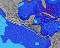 | 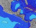 |  | 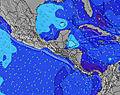 | ||||||||||||||
Wave Height (m) Direction Period (s) | SW 14 | SW 13 | SSW 13 | SW 13 | SW 16 | SW 12 | SW 15 | SW 15 | SW 14 | SW 14 | SW 13 | SW 13 | SSW 18 | SW 17 | SW 16 | SSW 16 | SW 15 | SW 15 | SW 14 | SW 14 | SW 13 |
Wave Graph | |||||||||||||||||||||
231 | 208 | 111 | 83 | 73 | 93 | 69 | 55 | 74 | 125 | 113 | 212 | 209 | 305 | 376 | 441 | 435 | 309 | 401 | 317 | 196 | |
Wind (km/h) | |||||||||||||||||||||
Wind State on-shore cross-onshore cross-shore cross-offshore off-shore glassy | glassy | on | off | cross-off | cross-on | off | cross-off | cross-on | off | off | cross-off | off | off | cross-on | off | off | glassy | off | off | off | off |
High Tide | 5:49PM2.19m | 6:13AM2.38m | 6:30PM2.12m | 6:55AM2.36m | 7:16PM2.04m | 7:43AM2.32m | 8:10PM1.96m | 8:39AM2.27m | 9:15PM1.90m | 9:45AM2.25m | 10:28PM1.90m | 10:57AM2.26m | 11:42PM1.98m | ||||||||
Low Tide | 11:47AM0.42m | 11:54PM0.35m | 12:29PM0.43m | 00:34AM0.40m | 1:15PM0.46m | 1:19AM0.46m | 2:09PM0.49m | 2:13AM0.52m | 3:11PM0.52m | 3:17AM0.57m | 4:21PM0.51m | 4:30AM0.58m | 5:32PM0.44m | ||||||||
5:31 | — | — | 5:31 | — | — | 5:33 | — | — | 5:33 | — | — | 5:33 | — | — | 5:33 | — | — | 5:33 | — | — | |
— | 6:06 | — | — | 6:05 | — | — | 6:05 | — | — | 6:05 | — | — | 6:04 | — | — | 6:04 | — | — | 6:04 | — | |
mm | — | — | — | — | 1 | 1 | — | 2 | 3 | 4 | 11 | 4 | — | — | — | — | 4 | 1 | — | — | — |
Temp °C | 30 | 30 | 28 | 32 | 29 | 28 | 30 | 29 | 27 | 28 | 27 | 25 | 29 | 30 | 27 | 30 | 28 | 25 | 30 | 30 | 27 |
Feels °C | 34 | 33 | 32 | 36 | 30 | 31 | 32 | 31 | 30 | 31 | 31 | 29 | 31 | 33 | 30 | 33 | 33 | 27 | 31 | 32 | 27 |
Swell 1 Height (m) Direction Period (s) | SW 14 | SW 13 | S 7 | S 9 | S 9 | S 8 | S 8 | S 8 | S 8 | S 8 | S 8 | S 8 | SW 13 | SW 17 | SW 16 | SSW 16 | SW 15 | SW 15 | SW 14 | SW 14 | SW 13 |
231 | 208 | 62 | 125 | 96 | 66 | 84 | 82 | 82 | 80 | 76 | 57 | 168 | 305 | 376 | 441 | 435 | 309 | 401 | 317 | 196 | |
Swell 2 Height (m) Direction Period (s) | S 7 | S 7 | SSW 13 | SW 13 | SW 12 | SW 12 | SW 12 | SW 12 | SW 14 | SW 14 | SW 13 | SW 13 | S 10 | SW 12 | SW 12 | SW 12 | S 8 | SW 11 | S 8 | S 10 | SW 16 |
52 | 49 | 111 | 83 | 73 | 93 | 69 | 49 | 74 | 125 | 113 | 212 | 92 | 151 | 144 | 139 | 51 | 79 | 33 | 49 | 124 | |
Swell 3 Height (m) Direction Period (s) | WSW 13 | SW 16 | SW 13 | SW 16 | SW 16 | N 4 | SW 15 | SW 15 | SW 11 | S 13 | S 12 | SW 18 | SSW 18 | S 9 | S 9 | S 8 | N 4 | S 9 | SW 18 | SSW 18 | S 10 |
69 | 66 | 84 | 64 | 61 | 6 | 54 | 55 | 20 | 31 | 25 | 159 | 209 | 76 | 55 | 50 | 3 | 38 | 12 | 31 | 47 | |
Wind waves Height (m) Direction Period (s) | — | — | — | NE 2 | SW 2 | — | NNE 3 | — | NNE 4 | — | — | N 5 | NE 3 | — | — | — | — | NNE 5 | NNE 6 | N 5 | NE 3 |
— | — | — | 2 | 1 | — | 2 | — | 3 | — | — | 14 | 2 | — | — | — | — | 18 | 10 | 11 | 3 | |
Nearest Offshore or Glassy | |||||||||||||||||||||
Distance (km) | 0 | 10 | 0 | 0 | 55 | 0 | 0 | 10 | 0 | 0 | 0 | 0 | 0 | 10 | 0 | 0 | 0 | 0 | 0 | 0 | 0 |
Best forecast wave conditions in Guanacaste | |||||||||||||||||||||
Best forecast wave conditions in Costa Rica | |||||||||||||||||||||
Header Global | |||||||||||||||||||||
- Map Icons:
 Break
Break Live Wave Height (m)
 Live Wind Speed (km/h)
 Surf Rating (10 Max)
 Ocean Swells (m)
- Wind Speed (km/h)
Latest Updates


FREE! Surf-Forecast.com widget for your website
The surf report / weather widget below is available to embed on third party websites free of charge and provides a summary of our El Estero surf forecast. Simply grab the html code snippet that we provide and paste it into your own site. You can choose your preferred language and metric/imperial units for the surf forecast feed to suit users of your site. Click here to get the code.
Information about the El Estero Surf forecast
The above surf forecast table for El Estero provides essential information for determining whether the surfing conditions will be good over the next 16 days. A general guide to surfing at El Estero can be found by selecting the local surf guide option on the grey menu. Our El Estero surf forecast is unique since it includes wave energy (power) that defines the real feel of the surf rather than just the height or the period. If you surf the same spot (El Estero) regularly then make a mental note of the wave energy from the surf forecast table each time you go. Very soon you may start to choose your surf days based on the wave energy alone combined with our forecast of favourable offshore wind conditions. Our star ratings will help here and of course you will also find the usual wave height and period predictions on our surf forecasts as well as a full break down of the swell components under our advanced users option (to reveal that, click the little Einstein character under the tide times).
Further information to help with frequently asked questions about our surf forecast for El Estero may be found under the help tab on the top menu and also by moving your mouse over the question marks on the surf forecast table itself. Please always bear in mind that the forecast is for near-shore open water and local factors at each surf break influence the actual breaking wave height, such as the beach / reef profile, water depths offshore and shelter.
El Estero is 47 km (29 miles) from Nicoya. If you plan a holiday in Guanacaste, look for hotels and other accommodation in Nicoya. Nicoya has rooms for a wide range of budgets as well as car hire and transport links.
 Nearest