

Surf Forecasts:

Dominacalito and The Point surf forecast from 20 Jul 2026:
- Best quality surf: Saturday 25 Jul, 3AM (local time) - 2.5ft (0.8m), 21s period, SW swell with cross-offshore winds.
- Most powerful swell: Monday 27 Jul, 6AM (local time) - 3.5ft (1.1m), 17s period, SW swell with 655 kJ wave energy.
- Next surfable swell (1★+): Monday 20 Jul, 6PM (local time) - 2ft (0.6m), 16s period with WSW swell.
Best Forecast Surf Conditions for Dominacalito and The Point this week:
The surf forecast for Dominacalito and The Point over the next 16 days: The first swell (rated 1 star or higher) is forecast to arrive on Monday (Jul 20) at 6PM. The primary swell is predicted to be 0.6m and 16s period with a secondary swell of 0.7m and 7s. Another secondary swell of 0.7m and 12s is also forecast. The wind is predicted to be glassy as the swell arrives.
The most powerful waves expected at Dominacalito and The Point in the next 16 days are 1.1m 17s and forecast to arrive on Monday (Jul 27) at 6AM. Winds are predicted to be glassy at the time the swell arrives.
| Wave Type | Time (CST) & Date | Wave Height & Period |
|---|---|---|
| Next good surf (1 star+) | 6PM (Mon 20th Jul) | 2ft (0.6m) 16s |
| Best Surf | 3AM (Sat 25th Jul) | 2.5ft (0.8m) 21s |
| Most Powerful | 6AM (Mon 27th Jul) | 3.5ft (1.1m) 17s |
Table - best surf conditions forecast for Dominacalito and The Point over the next 16 days.
The Lowdown
Alright folks, Rusty here. Let’s get into it for Dominacalito and The Point.
We’re looking at a quiet start, but the second half of the window is where it gets real interesting. The water is sitting at a warm 87°, which is a touch warmer than normal for this time of year, so you’ll be comfortable in a spring suit or boardies.
The first real green light comes on Monday, July 20th. The morning is glassy with a 2ft swell from the WSW, and the period is a very long 16 seconds. That’s proper groundswell energy, and with the combined energy reading 353, it’s got some substance. That long period will be lining up nicely at the point. It’s small, but it’ll be clean. The afternoon stays glassy, with a slight shift to the SW.
Tuesday, July 21st, keeps the glassy theme going in the morning. Swell bumps up a touch to 2ft from the SW, still with a nice 14-second period. The energy is moderate at 309. Conditions are clean. The afternoon gets a cross-on wind, but it’s light, so it’s not a write-off.
Thursday, July 23rd, is a standout. The afternoon brings a clean 4ft swell from the SW with a short 7-second period, but the wind flips offshore from the NNE at 5 km/h. The energy jumps to 274. That offshore wind will have the waves standing up nicely. This is a good one.
Now, Friday July 24th is a washout. Strong WNW winds at 15 km/h and a big 24-second period, but the swell is tiny and messy. The energy is high at 523, but it’s all cross-onshore chop. Save your energy.
The real magic starts rolling in from Saturday, July 25th, and runs through the end of the window. The standout on offer is Sunday, July 26th. The morning is glassy, with a 3ft SW swell and a long 19-second period. The combined energy is a solid 504, and the forecast even says “expect very good surf conditions.” That’s the best of the bunch for the first week.
Monday, July 27th, and Tuesday, July 28th, are also excellent. Monday morning is glassy with a 2ft SW swell, 19-second period, and energy hitting 718. Tuesday morning is glassy again, with the swell stepping up to 3ft from the SW, 18-second period, and energy at 780. These are all clean, glassy mornings with quality groundswell.
By Wednesday, July 29th, it’s still going. Glassy morning, 4ft SW swell, 16-second period, and energy at 680. The wind is dead calm. This is as good as it gets for the conditions.
The forecast for August 3rd and 4th picks up again. Monday, August 3rd, has glassy conditions with a 2ft to 3ft SW swell, and the energy is moderate at 365 to 398. Tuesday, August 4th, is glassy again with a 3ft SW swell and energy at 403.
The best call for the whole run is the morning of Tuesday, July 28th, with that 3ft, 18-second groundswell, dead calm conditions, and high energy. Dominacalito and The Point will be the place to be. It’s a fairly consistent spot, so you might have some company, but the quality will be worth it.
Stay stoked, and I’ll see you out there.
Rusty
Short Range ForecastHeavy rain (total 20mm), heaviest during Wed night. Warm (max 28°C on Mon morning, min 25°C on Mon afternoon). Wind will be generally light. | Days 4-6 Weather SummaryHeavy rain (total 44mm), heaviest during Thu afternoon. Warm (max 29°C on Sat morning, min 25°C on Thu night). Wind will be generally light. | ||||||||||||||||||||
Monday 20 | Tuesday 21 | Wednesday 22 | Thursday 23 | Friday 24 | Saturday 25 | Sunday 26 | |||||||||||||||
AM | PM | Night | AM | PM | Night | AM | PM | Night | AM | PM | Night | AM | PM | Night | AM | PM | Night | AM | PM | Night | |
Swell Height Map |  |  |  | 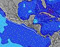 | 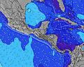 | 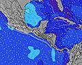 | 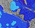 | ||||||||||||||
Wave Height (m) Direction Period (s) | WSW 16 | SW 16 | SW 15 | SW 14 | SW 14 | SW 13 | SW 13 | SW 12 | SW 12 | SSW 6 | SW 26 | SW 7 | SW 24 | SW 24 | SW 21 | SW 21 | SW 20 | SW 19 | SW 19 | SW 18 | SW 17 |
Wave Graph | |||||||||||||||||||||
175 | 203 | 178 | 211 | 218 | 286 | 140 | 146 | 114 | 71 | 112 | 105 | 347 | 195 | 449 | 368 | 251 | 627 | 436 | 522 | 493 | |
Wind (km/h) | |||||||||||||||||||||
Wind State on-shore cross-onshore cross-shore cross-offshore off-shore glassy | glassy | glassy | glassy | glassy | cross-on | glassy | cross | glassy | off | glassy | off | cross | cross-on | cross-on | cross | glassy | on | cross-off | glassy | on | glassy |
High Tide | 7:22PM2.48m | 7:48AM2.65m | 8:13PM2.31m | 8:37AM2.50m | 9:08PM2.16m | 9:30AM2.37m | 10:10PM2.05m | 10:29AM2.28m | 11:15PM2.02m | 11:30AM2.27m | 00:17AM2.05m | 12:27PM2.31m | 1:11AM2.14m | ||||||||
Low Tide | 1:19PM0.47m | 1:29AM0.50m | 2:10PM0.60m | 2:17AM0.69m | 3:04PM0.71m | 3:10AM0.83m | 4:03PM0.78m | 4:09AM0.93m | 5:05PM0.80m | 5:12AM0.96m | 6:04PM0.76m | 6:12AM0.93m | 6:58PM0.68m | ||||||||
5:22 | — | — | 5:24 | — | — | 5:24 | — | — | 5:24 | — | — | 5:24 | — | — | 5:24 | — | — | 5:24 | — | — | |
— | 5:58 | — | — | 5:58 | — | — | 5:58 | — | — | 5:58 | — | — | 5:58 | — | — | 5:58 | — | — | 5:58 | — | |
mm | — | 4 | — | — | 3 | 4 | — | 4 | 5 | 1 | 16 | 5 | 6 | 6 | 3 | — | 1 | 6 | — | 4 | 6 |
Temp °C | 28 | 27 | 26 | 28 | 28 | 26 | 27 | 27 | 26 | 28 | 26 | 26 | 27 | 26 | 25 | 29 | 28 | 26 | 27 | 27 | 26 |
Feels °C | 32 | 32 | 30 | 32 | 32 | 30 | 32 | 32 | 30 | 32 | 31 | 30 | 29 | 29 | 29 | 33 | 33 | 30 | 32 | 31 | 31 |
Swell 1 Height (m) Direction Period (s) | SW 6 | SW 6 | SW 15 | SW 14 | SW 14 | SW 13 | SW 13 | SW 12 | SW 12 | SSW 6 | SW 7 | SW 7 | SW 7 | SW 7 | SW 21 | SW 21 | SW 20 | SW 19 | SW 19 | SW 18 | SW 17 |
42 | 42 | 178 | 211 | 218 | 286 | 140 | 146 | 114 | 71 | 112 | 105 | 125 | 112 | 449 | 368 | 251 | 627 | 436 | 522 | 493 | |
Swell 2 Height (m) Direction Period (s) | SSW 12 | SSW 12 | SW 7 | SSW 11 | SSW 11 | SW 6 | SSW 11 | SSW 6 | SSW 6 | SW 12 | SW 13 | SW 13 | SW 24 | SW 24 | WSW 6 | SSW 8 | SSW 8 | SSW 8 | SSW 8 | SSW 10 | S 10 |
136 | 131 | 46 | 71 | 93 | 5 | 65 | 7 | 23 | 51 | 57 | 27 | 347 | 195 | 35 | 37 | 36 | 56 | 37 | 77 | 49 | |
Swell 3 Height (m) Direction Period (s) | WSW 16 | SW 16 | SSW 12 | SSW 6 | SW 6 | W 11 | WSW 6 | WSW 6 | W 9 | SSW 10 | SW 26 | SSW 10 | SW 12 | SW 12 | S 8 | WSW 6 | WSW 7 | SW 11 | SW 11 | SW 11 | WSW 9 |
175 | 203 | 125 | 27 | 10 | 2 | 3 | 3 | 7 | 10 | 105 | 11 | 51 | 23 | 29 | 17 | 18 | 33 | 31 | 19 | 17 | |
Wind waves Height (m) Direction Period (s) | — | — | — | — | — | — | — | — | — | — | — | — | — | — | — | — | — | — | — | — | — |
— | — | — | — | — | — | — | — | — | — | — | — | — | — | — | — | — | — | — | — | — | |
Nearest Offshore or Glassy | |||||||||||||||||||||
Distance (km) | 0 | 0 | 0 | 0 | 108 | 0 | 12 | 0 | 0 | 0 | 0 | 33 | 59 | 49 | 12 | 0 | 79 | 0 | 0 | 12 | 0 |
Best forecast wave conditions in Golfo de Nicoya | |||||||||||||||||||||
Best forecast wave conditions in Costa Rica | |||||||||||||||||||||
Header Global | |||||||||||||||||||||
- Map Icons:
 Break
Break Live Wave Height (m)
 Live Wind Speed (km/h)
 Surf Rating (10 Max)
 Ocean Swells (m)
- Wind Speed (km/h)


FREE! Surf-Forecast.com widget for your website
The surf report / weather widget below is available to embed on third party websites free of charge and provides a summary of our Dominacalito and The Point surf forecast. Simply grab the html code snippet that we provide and paste it into your own site. You can choose your preferred language and metric/imperial units for the surf forecast feed to suit users of your site. Click here to get the code.
Information about the Dominacalito and The Point Surf forecast
The above surf forecast table for Dominacalito and The Point provides essential information for determining whether the surfing conditions will be good over the next 16 days. A general guide to surfing at Dominacalito and The Point can be found by selecting the local surf guide option on the grey menu. Our Dominacalito and The Point surf forecast is unique since it includes wave energy (power) that defines the real feel of the surf rather than just the height or the period. If you surf the same spot (Dominacalito and The Point) regularly then make a mental note of the wave energy from the surf forecast table each time you go. Very soon you may start to choose your surf days based on the wave energy alone combined with our forecast of favourable offshore wind conditions. Our star ratings will help here and of course you will also find the usual wave height and period predictions on our surf forecasts as well as a full break down of the swell components under our advanced users option (to reveal that, click the little Einstein character under the tide times).
Further information to help with frequently asked questions about our surf forecast for Dominacalito and The Point may be found under the help tab on the top menu and also by moving your mouse over the question marks on the surf forecast table itself. Please always bear in mind that the forecast is for near-shore open water and local factors at each surf break influence the actual breaking wave height, such as the beach / reef profile, water depths offshore and shelter.
Are you planning a holiday in Golfo de Nicoya? If you are looking for accommodation near Dominacalito and The Point, camping, hotels and holiday cottages in Golfo de Nicoya, consider staying in San Isidro which is 27 km (17 miles) away. Other places in and around Golfo de Nicoya where you can find information about places to rent, and car hire include Quepos which is 54 km (34 miles) away, Paraiso, Cartago and Turrialba.
 Nearest