

Surf Forecasts:

How big are the waves at Corinto today (27 Jul):
- Morning surf: Morning surf (27 Jul, local time) - 4.5ft (1.4m), 18s period with SW swell.
- Afternoon surf: Afternoon surf (27 Jul, local time) - 3.5ft (1.1m), 17s period with SW swell.
- Evening surf: Evening surf (27 Jul, local time) - 4ft (1.2m), 17s period with SW swell.
The current surf forecast for Corinto at 4PM is: 1.1m 17s primary swell from a Southwest direction and 0.9m 19s secondary swell from a Southwest direction, 0.5m 10s secondary swell from a South-southwest direction (forecast issued at 11:00am July 27). The wind direction is predicted to be onshore.
| Time (CST) & Date | Wave Height | Wave Period |
|---|---|---|
| Morning (27 Jul) | 4.5ft (1.4m) | 18s |
| Afternoon (27 Jul) | 3.5ft (1.1m) | 17s |
| Evening (27 Jul) | 4ft (1.2m) | 17s |
Table - waves today at Corinto. (Swell directed towards the surf break)
Short Range ForecastLight rain (total 5mm), mostly falling on Wed afternoon. Warm (max 32°C on Mon morning, min 25°C on Tue night). Wind will be generally light. | |||||||||||||||||||||
Mon 27 | Tuesday 28 | Wednesday 29 | |||||||||||||||||||
9 AM | 12 PM | 3 PM | 6 PM | 9 PM | 12 AM | 3 AM | 6 AM | 9 AM | 12 PM | 3 PM | 6 PM | 9 PM | 12 AM | 3 AM | 6 AM | 9 AM | 12 PM | 3 PM | 6 PM | 9 PM | |
Swell Height Map |  |  |  | 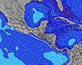 |  |  | 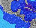 |  | |||||||||||||
Wave Height (m) Direction Period (s) | SW 18 | SW 19 | SW 17 | SW 16 | SW 17 | SW 17 | SSW 18 | SSW 18 | SW 18 | SW 18 | SW 17 | SW 17 | SW 16 | SW 16 | SW 16 | SW 16 | SW 16 | SW 16 | SW 16 | SW 16 | SW 16 |
Wave Graph | |||||||||||||||||||||
1149 | 1296 | 702 | 694 | 825 | 1235 | 1399 | 1399 | 1351 | 1351 | 1336 | 1305 | 1201 | 1158 | 1057 | 1044 | 1031 | 1018 | 1005 | 993 | 871 | |
Wind (km/h) | |||||||||||||||||||||
Wind State on-shore cross-onshore cross-shore cross-offshore off-shore glassy | cross-off | cross-on | on | on | glassy | cross-off | cross-off | off | glassy | on | on | on | on | glassy | glassy | off | off | on | cross-on | glassy | cross-off |
High Tide | 1:13PM2.01m | 1:52AM1.78m | 2:00PM2.08m | 2:36AM1.89m | 2:42PM2.13m | ||||||||||||||||
Low Tide | 7:00AM0.70m | 7:49PM0.50m | 7:49AM0.63m | 8:30PM0.42m | 8:34AM0.57m | ||||||||||||||||
5:33 | — | — | — | — | — | 5:33 | — | — | — | — | — | — | — | 5:33 | — | — | — | — | — | — | |
— | — | — | 6:16 | — | — | — | — | — | — | — | 6:16 | — | — | — | — | — | — | — | 6:15 | — | |
mm | — | — | — | — | — | — | — | — | — | — | — | — | — | 1 | — | — | — | — | — | 3 | 1 |
Temp °C | 29 | 32 | 31 | 29 | 29 | 28 | 27 | 26 | 29 | 31 | 30 | 29 | 28 | 28 | 27 | 25 | 29 | 31 | 30 | 27 | 27 |
Feels °C | 31 | 34 | 32 | 32 | 33 | 32 | 31 | 29 | 32 | 32 | 31 | 32 | 32 | 33 | 32 | 28 | 33 | 33 | 32 | 32 | 31 |
Swell 1 Height (m) Direction Period (s) | SW 18 | SW 19 | SW 17 | SW 16 | SW 17 | SW 17 | SSW 18 | SSW 18 | SW 18 | SW 18 | SW 17 | SW 17 | SW 16 | SW 16 | SW 16 | SW 16 | SW 16 | SW 16 | SW 16 | SW 16 | SW 16 |
1149 | 1296 | 702 | 694 | 825 | 1235 | 1399 | 1399 | 1351 | 1351 | 1336 | 1305 | 1201 | 1158 | 1057 | 1044 | 1031 | 1018 | 1005 | 993 | 871 | |
Swell 2 Height (m) Direction Period (s) | S 10 | S 10 | SW 19 | SW 19 | SW 20 | S 9 | SE 5 | SE 5 | S 9 | S 9 | — | SW 9 | SSW 9 | SSW 9 | SSW 9 | SSW 9 | SSW 9 | SSW 9 | SSW 11 | SSW 11 | SSW 10 |
47 | 46 | 546 | 450 | 388 | 40 | 39 | 23 | 38 | 25 | — | 38 | 30 | 30 | 26 | 15 | 16 | 26 | 66 | 37 | 35 | |
Swell 3 Height (m) Direction Period (s) | SE 5 | S 10 | S 10 | SSW 10 | S 10 | S 12 | W 9 | — | — | — | — | S 11 | S 11 | S 11 | S 11 | S 11 | S 11 | S 11 | — | — | W 10 |
13 | 47 | 68 | 52 | 47 | 12 | 6 | — | — | — | — | 10 | 10 | 10 | 10 | 2 | 2 | 2 | — | — | 8 | |
Wind waves Height (m) Direction Period (s) | — | — | SSW 10 | — | — | — | — | — | — | — | SW 9 | — | — | — | — | — | — | — | SW 11 | — | — |
— | — | 52 | — | — | — | — | — | — | — | 49 | — | — | — | — | — | — | — | 56 | — | — | |
Nearest Offshore or Glassy | |||||||||||||||||||||
Distance (km) | 0 | 93 | 77 | 238 | 0 | 0 | 0 | 0 | 0 | 77 | 129 | 109 | 77 | 0 | 0 | 0 | 0 | 77 | 105 | 0 | 0 |
Best forecast wave conditions in Leon Province | |||||||||||||||||||||
Best forecast wave conditions in Nicaragua | |||||||||||||||||||||
Header Global | |||||||||||||||||||||
- Map Icons:
 Break
Break Live Wave Height (m)
 Live Wind Speed (km/h)
 Surf Rating (10 Max)
 Ocean Swells (m)
- Wind Speed (km/h)


FREE! Surf-Forecast.com widget for your website
The surf report / weather widget below is available to embed on third party websites free of charge and provides a summary of our Corinto surf forecast. Simply grab the html code snippet that we provide and paste it into your own site. You can choose your preferred language and metric/imperial units for the surf forecast feed to suit users of your site. Click here to get the code.
 Nearest