

Surf Forecasts:

Beau Vallon Beach surf forecast from 27 Jul 2026:
- Most powerful swell: Saturday 1 Aug, 4AM (local time) - 6ft (1.9m), 10s period, SE swell with 667 kJ wave energy.
Best Forecast Surf Conditions for Beau Vallon Beach this week:
The most powerful waves expected at Beau Vallon Beach in the next 16 days are 1.9m 10s and forecast to arrive on Saturday (Aug 01) at 4AM. Winds are predicted to be cross-shore at the time the swell arrives. The largest open ocean swell (not directed at the beach) is 1.6m 8s period and expected on Thursday (Jul 30) at 7PM.
| Wave Type | Time (+04) & Date | Wave Height & Period |
|---|---|---|
| Next good surf (1 star+) | - | - |
| Best Surf | - | - |
| Most Powerful | 4AM (Sat 1st Aug) | 6ft (1.9m) 10s |
Table - best surf conditions forecast for Beau Vallon Beach over the next 16 days.
The Lowdown
Alright folks, Rusty here. Let me tell you straight up, it’s a tough run coming in for Beau Vallon Beach. The whole 16-day window is a write-off for any decent surf. We’ve got consistent swell, no doubt, but the wind is a total killer. It’s locked in from the SE and SSE, blowing cross-shore and cross-onshore, and it’s not letting up. The water is a touch warmer than normal for this time of year, sitting at 81°F, but that’s about the only nice thing I can say.
Right from the start on Monday the 27th, we’ve got a 6ft SE swell coming in with a period of 10 seconds, giving us moderate wave energy (602), but the 19 mph cross-shore wind has got the ocean looking like a washing machine. The "poor surf conditions" tag is bang on. This pattern just keeps rolling through the week: Tuesday the 28th, Wednesday the 29th, Thursday the 30th – all cross-shore, all lumpy, all poor. The swell drops slightly on Thursday to 4ft, but the wind is still a mess.
Heading into the first week of August, the wind doesn’t shift. Friday the 31st sees a 5ft spike with a short, weak 6-second period (285 energy), but it’s a cross-shore mess. Saturday the 1st of August pumps a 6ft swell (563 energy) but again, 22 mph cross-shore winds ruin it. This pattern of moderate swell and ripping cross-shore wind is relentless. We get a little break in the wind speed on Monday the 3rd of August, dropping to 9 mph, but it turns cross-onshore and choppy. The swell is only 4ft.
Things get a bit more interesting from the 6th of August onward, with swell heights pushing over 7ft and even hitting 8ft on Tuesday the 11th of August. The wave energy jumps into the strong zone, with readings over 1000. But for a beach break like Beau Vallon, with these cross-shore winds, that kind of size is just a messy, lumpy, and dangerous wall of white water. The period is mostly around 9-10 seconds, which is moderate, but the wind just won’t cooperate. The only session that even gets a marginal rating is Thursday afternoon the 6th of August, with a 7ft SE swell and the wind dropping to 12 mph, but it’s still cross-shore with a chop. It’s not worth paddling out for.
Honestly, with this constant wind and the beach setup, it looks more interesting for kite surfing than paddle surfing. The swell is there, but the quality is zero. It’s a blank run of 16 days, and for this area, that’s not unusual when you get a stubborn wind pattern like this. Forecasts can change, but as it stands, leave the boards at home.
Rusty.
Short Range ForecastSome drizzle, heaviest during Wed night. Warm (max 26°C on Mon afternoon, min 25°C on Wed night). Mainly fresh winds. | Days 5-7 Weather SummaryLight rain (total 3mm), mostly falling on Fri afternoon. Warm (max 26°C on Thu afternoon, min 25°C on Thu afternoon). Mainly fresh winds. | |||||||||||||||||||
Mon 27 | Tuesday 28 | Wednesday 29 | Thursday 30 | Friday 31 | Saturday 1 | Sunday 2 | ||||||||||||||
PM | Night | AM | PM | Night | AM | PM | Night | AM | PM | Night | AM | PM | Night | AM | PM | Night | AM | PM | Night | |
Swell Height Map | 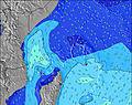 | 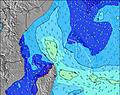 | 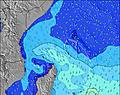 | 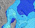 | 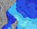 | 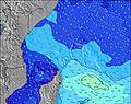 | 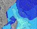 | |||||||||||||
Wave Height (m) Direction Period (s) | SE 10 | SE 7 | SE 7 | SE 8 | SE 8 | SE 8 | SE 8 | SE 8 | ESE 9 | ESE 8 | ESE 9 | ESE 10 | ESE 10 | SE 10 | SE 9 | ESE 10 | SE 8 | SE 9 | SE 9 | SE 9 |
Wave Graph | ||||||||||||||||||||
602 | 284 | 336 | 413 | 498 | 486 | 428 | 439 | 227 | 171 | 132 | 166 | 148 | 566 | 552 | 242 | 311 | 384 | 318 | 287 | |
Wind (km/h) | ||||||||||||||||||||
Wind State on-shore cross-onshore cross-shore cross-offshore off-shore glassy | cross | cross | cross | cross | cross | cross | cross | cross | cross | cross | cross | cross | cross | cross | cross | cross | cross | cross | cross | cross |
High Tide | 4:30AM0.77m | 4:22PM1.34m | 5:02AM0.85m | 4:56PM1.39m | 5:33AM0.94m | 5:27PM1.41m | 6:03AM1.02m | 5:57PM1.40m | 6:33AM1.10m | 6:26PM1.35m | 7:04AM1.17m | 6:55PM1.28m | ||||||||
Low Tide | 10:48PM0.19m | 9:41AM0.32m | 11:16PM0.14m | 10:23AM0.28m | 11:42PM0.10m | 11:01AM0.25m | 00:07AM0.07m | 11:38AM0.24m | 00:31AM0.06m | 12:15PM0.25m | 00:54AM0.07m | 12:53PM0.27m | 1:18AM0.08m | |||||||
— | — | 6:26 | — | — | 6:26 | — | — | 6:26 | — | — | 6:26 | — | — | 6:26 | — | — | 6:26 | — | — | |
6:21 | — | — | 6:21 | — | — | 6:22 | — | — | 6:22 | — | — | 6:22 | — | — | 6:22 | — | — | 6:22 | — | |
mm | — | — | — | — | — | — | — | 1 | — | — | — | — | 1 | 2 | — | — | — | — | — | — |
Temp °C | 26 | 26 | 26 | 26 | 26 | 26 | 26 | 26 | 26 | 26 | 26 | 26 | 26 | 26 | 26 | 26 | 25 | 25 | 26 | 26 |
Feels °C | 25 | 25 | 25 | 24 | 24 | 24 | 25 | 25 | 25 | 26 | 25 | 25 | 25 | 25 | 24 | 24 | 23 | 23 | 26 | 26 |
Swell 1 Height (m) Direction Period (s) | S 10 | S 10 | ESE 11 | ESE 11 | SSW 16 | SSW 14 | S 20 | SE 8 | ESE 9 | ESE 8 | ESE 9 | ESE 10 | ESE 10 | SSW 13 | SSW 12 | ESE 10 | SSE 9 | SSW 18 | SE 9 | SSW 16 |
45 | 47 | 128 | 40 | 84 | 67 | 194 | 439 | 227 | 171 | 132 | 166 | 137 | 33 | 26 | 242 | 69 | 103 | 318 | 86 | |
Swell 2 Height (m) Direction Period (s) | SSW 14 | SSW 21 | SSW 18 | SSW 17 | SW 8 | SSW 21 | SSW 13 | SSW 18 | SSW 16 | SSW 16 | SSW 15 | SSW 14 | SSW 13 | NE 11 | SSW 15 | SSW 12 | SSW 13 | SSE 18 | SSW 18 | SSE 17 |
41 | 86 | 65 | 57 | 10 | 88 | 59 | 246 | 203 | 198 | 121 | 61 | 59 | 4 | 22 | 27 | 16 | 32 | 102 | 56 | |
Swell 3 Height (m) Direction Period (s) | S 14 | SSW 13 | SSE 20 | SSE 18 | SSW 11 | SW 8 | SSE 20 | SSE 18 | SSE 17 | SSE 16 | SSE 15 | S 14 | S 14 | S 19 | SE 17 | SSW 18 | SSW 19 | SSW 10 | SSE 18 | SSW 11 |
16 | 17 | 37 | 31 | 25 | 10 | 38 | 108 | 94 | 86 | 45 | 36 | 15 | 7 | 11 | 30 | 34 | 11 | 61 | 13 | |
Wind waves Height (m) Direction Period (s) | SE 10 | SE 7 | SE 7 | SE 8 | SE 8 | SE 8 | SE 8 | — | SSE 8 | SSE 8 | SSE 8 | SSE 7 | SSE 6 | SE 10 | SE 9 | SSE 9 | SE 8 | SE 9 | — | SE 9 |
602 | 284 | 336 | 413 | 498 | 486 | 428 | — | 244 | 300 | 354 | 228 | 148 | 566 | 552 | 238 | 311 | 384 | — | 287 | |
Nearest Offshore or Glassy | ||||||||||||||||||||
Distance (km) | 1726 | 1736 | 1748 | 1748 | 1741 | 1748 | 1741 | 1748 | 1748 | 1772 | 1748 | 1748 | 1748 | 1748 | 1765 | 1765 | 1775 | 1775 | 15 | 15 |
Best forecast wave conditions in Mahe | ||||||||||||||||||||
Best forecast wave conditions in Seychelles | ||||||||||||||||||||
Header Global | ||||||||||||||||||||
- Map Icons:
 Break
Break Live Wave Height (m)
 Live Wind Speed (km/h)
 Surf Rating (10 Max)
 Ocean Swells (m)
- Wind Speed (km/h)


FREE! Surf-Forecast.com widget for your website
The surf report / weather widget below is available to embed on third party websites free of charge and provides a summary of our Beau Vallon Beach surf forecast. Simply grab the html code snippet that we provide and paste it into your own site. You can choose your preferred language and metric/imperial units for the surf forecast feed to suit users of your site. Click here to get the code.
Information about the Beau Vallon Beach Surf forecast
The above surf forecast table for Beau Vallon Beach provides essential information for determining whether the surfing conditions will be good over the next 16 days. A general guide to surfing at Beau Vallon Beach can be found by selecting the local surf guide option on the grey menu. Our Beau Vallon Beach surf forecast is unique since it includes wave energy (power) that defines the real feel of the surf rather than just the height or the period. If you surf the same spot (Beau Vallon Beach) regularly then make a mental note of the wave energy from the surf forecast table each time you go. Very soon you may start to choose your surf days based on the wave energy alone combined with our forecast of favourable offshore wind conditions. Our star ratings will help here and of course you will also find the usual wave height and period predictions on our surf forecasts as well as a full break down of the swell components under our advanced users option (to reveal that, click the little Einstein character under the tide times).
Further information to help with frequently asked questions about our surf forecast for Beau Vallon Beach may be found under the help tab on the top menu and also by moving your mouse over the question marks on the surf forecast table itself. Please always bear in mind that the forecast is for near-shore open water and local factors at each surf break influence the actual breaking wave height, such as the beach / reef profile, water depths offshore and shelter.
Are you planning a holiday in Mahe? If you are looking for accommodation near Beau Vallon Beach, camping, hotels and holiday cottages in Mahe, consider staying in Victoria which is 3 km (2 miles) away.
 Nearest