

Surf Forecasts:

Arashi Bay Reef surf forecast from 2 Aug 2026:
- Most powerful swell: Saturday 8 Aug, 2AM (local time) - 0.5ft (0.1m), 9s period, N swell with 2 kJ wave energy.
Best Forecast Surf Conditions for Arashi Bay Reef this week:
The most powerful waves expected at Arashi Bay Reef in the next 16 days are 0.1m 9s and forecast to arrive on Saturday (Aug 08) at 2AM. Winds are predicted to be offshore at the time the swell arrives. The largest open ocean swell (not directed at the beach) is 2.5m 8s period and expected on Sunday (Aug 02) at 2AM.
| Wave Type | Time (AST) & Date | Wave Height & Period |
|---|---|---|
| Next good surf (1 star+) | - | - |
| Best Surf | - | - |
| Most Powerful | 2AM (Sat 8th Aug) | 0.5ft (0.1m) 9s |
Table - best surf conditions forecast for Arashi Bay Reef over the next 16 days.
The Lowdown
Imperial
Alright, let’s get straight to it. To be honest, the whole period is a bit of a heartbreaker. We’re looking at Arashi Bay Reef (Aruba), and for the next two weeks, the surf is all but non-existent. Straight up, there’s nothing to get excited about.
The entire 16-day window from August 2nd right through to August 17th is a total flat spell. The combined swell energy barely even registers, sitting at a measly 0 (zero) for nearly every entry, and the only hint of life is a tiny 0.3 ft north-northwest swell on the afternoon of August 8th, but with a period of just 9 seconds and no energy behind it, that’s not gonna do a thing for this exposed reef. This spot rarely breaks as it is, so a blank run like this is actually pretty normal for the area.
The winds are relentless. We got strong breeze from the east at 25 to 31 mph almost every day, with afternoon gusts reaching near gale force. While that offshore E/ENE wind keeps the water’s surface clean, it’s a battle just to paddle out. The water temperature anomaly is about average for this time of year, so no surprises there.
So, plain and simple: nothing’s breaking. You want to surf? You might be better off waiting for a change in the forecast. But as it stands, there are zero good surf options in this 16-day window. Don’t hang up your board just yet, though – forecasts can change.
Rusty.
Short Range ForecastMostly dry. Warm (max 27°C on Sat night, min 27°C on Sat night). Mainly strong winds. | Days 5-7 Weather SummaryMostly dry. Warm (max 27°C on Tue night, min 27°C on Tue night). Mainly strong winds. | ||||||||||||||||||
Sunday 2 | Monday 3 | Tuesday 4 | Wednesday 5 | Thursday 6 | Friday 7 | ||||||||||||||
Night | AM | PM | Night | AM | PM | Night | AM | PM | Night | AM | PM | Night | AM | PM | Night | AM | PM | Night | |
Swell Height Map |  |  |  | 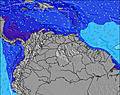 | 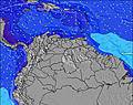 | 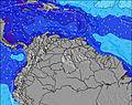 | 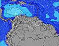 | ||||||||||||
Wave Height (m) Direction Period (s) | E 8 | E 8 | E 7 | E 8 | E 7 | E 7 | E 7 | E 8 | E 8 | E 7 | E 7 | E 7 | E 7 | E 7 | E 7 | E 8 | E 8 | E 8 | N 9 |
Wave Graph | |||||||||||||||||||
0 | 0 | 0 | 0 | 0 | 0 | 0 | 0 | 0 | 0 | 0 | 0 | 0 | 0 | 0 | 0 | 0 | 0 | 2 | |
Wind (km/h) | |||||||||||||||||||
Wind State on-shore cross-onshore cross-shore cross-offshore off-shore glassy | cross-off | cross-off | off | cross-off | cross-off | off | off | cross-off | off | cross-off | cross-off | off | cross-off | cross-off | off | cross-off | cross-off | off | off |
High Tide | 1:43AM0.26m | 5:33PM0.23m | 1:36AM0.22m | 5:52PM0.26m | 00:40AM0.18m | 6:20PM0.30m | 6:29AM0.12m | 6:56PM0.33m | 7:49AM0.09m | 7:36PM0.35m | 8:59AM0.06m | 8:21PM0.38m | |||||||
Low Tide | 9:36AM0.11m | 9:29PM0.19m | 9:40AM0.11m | 11:36PM0.18m | 9:53AM0.10m | 4:38AM0.12m | 10:10AM0.09m | 4:53AM0.07m | 10:31AM0.07m | 5:21AM0.03m | |||||||||
— | 6:26 | — | — | 6:26 | — | — | 6:26 | — | — | 6:26 | — | — | 6:26 | — | — | 6:26 | — | — | |
7:06 | — | 7:06 | — | — | 7:05 | — | — | 7:05 | — | — | 7:05 | — | — | 7:04 | — | — | 7:04 | — | |
mm | — | — | — | — | — | — | — | — | — | — | — | — | — | — | — | — | — | — | — |
Temp °C | 27 | 27 | 27 | 27 | 27 | 27 | 27 | 27 | 27 | 27 | 27 | 27 | 27 | 27 | 27 | 27 | 27 | 27 | 27 |
Feels °C | 23 | 25 | 25 | 23 | 25 | 25 | 24 | 25 | 25 | 24 | 26 | 26 | 25 | 25 | 25 | 23 | 25 | 25 | 25 |
Swell 1 Height (m) Direction Period (s) | — | — | — | — | — | — | — | — | — | — | — | — | — | — | — | — | — | — | N 9 |
— | — | — | — | — | — | — | — | — | — | — | — | — | — | — | — | — | — | 2 | |
Swell 2 Height (m) Direction Period (s) | — | — | — | — | — | — | — | — | — | — | — | — | — | — | — | — | — | — | — |
— | — | — | — | — | — | — | — | — | — | — | — | — | — | — | — | — | — | — | |
Swell 3 Height (m) Direction Period (s) | — | — | — | — | — | — | — | — | — | — | — | — | — | — | — | — | — | — | — |
— | — | — | — | — | — | — | — | — | — | — | — | — | — | — | — | — | — | — | |
Wind waves Height (m) Direction Period (s) | E 8 | E 8 | E 7 | E 8 | E 7 | E 7 | E 7 | E 8 | E 8 | E 7 | E 7 | E 7 | E 7 | E 7 | E 7 | E 8 | E 8 | E 8 | E 7 |
776 | 585 | 524 | 699 | 524 | 470 | 562 | 593 | 593 | 562 | 465 | 425 | 587 | 539 | 554 | 826 | 766 | 709 | 572 | |
Nearest Offshore or Glassy | |||||||||||||||||||
Distance (km) | 297 | 323 | 402 | 311 | 402 | 402 | 297 | 311 | 402 | 297 | 323 | 402 | 311 | 333 | 402 | 297 | 402 | 402 | 311 |
Best forecast wave conditions in Aruba | |||||||||||||||||||
Best forecast wave conditions in Aruba | |||||||||||||||||||
Header Global | |||||||||||||||||||
- Map Icons:
 Break
Break Live Wave Height (m)
 Live Wind Speed (km/h)
 Surf Rating (10 Max)
 Ocean Swells (m)
- Wind Speed (km/h)
Latest Updates


FREE! Surf-Forecast.com widget for your website
The surf report / weather widget below is available to embed on third party websites free of charge and provides a summary of our Arashi Bay Reef surf forecast. Simply grab the html code snippet that we provide and paste it into your own site. You can choose your preferred language and metric/imperial units for the surf forecast feed to suit users of your site. Click here to get the code.
Information about the Arashi Bay Reef Surf forecast
The above surf forecast table for Arashi Bay Reef provides essential information for determining whether the surfing conditions will be good over the next 16 days. A general guide to surfing at Arashi Bay Reef can be found by selecting the local surf guide option on the grey menu. Our Arashi Bay Reef surf forecast is unique since it includes wave energy (power) that defines the real feel of the surf rather than just the height or the period. If you surf the same spot (Arashi Bay Reef) regularly then make a mental note of the wave energy from the surf forecast table each time you go. Very soon you may start to choose your surf days based on the wave energy alone combined with our forecast of favourable offshore wind conditions. Our star ratings will help here and of course you will also find the usual wave height and period predictions on our surf forecasts as well as a full break down of the swell components under our advanced users option (to reveal that, click the little Einstein character under the tide times).
Further information to help with frequently asked questions about our surf forecast for Arashi Bay Reef may be found under the help tab on the top menu and also by moving your mouse over the question marks on the surf forecast table itself. Please always bear in mind that the forecast is for near-shore open water and local factors at each surf break influence the actual breaking wave height, such as the beach / reef profile, water depths offshore and shelter.
 Nearest