

Surf Forecasts:

Tamarindo Playa Serena (Mar del Plata) surf forecast from 9 Jul 2026:
- Best quality surf: Saturday 11 Jul, 3AM (local time) - 3.5ft (1.0m), 10s period, ESE swell with cross-offshore winds.
- Most powerful swell: Friday 10 Jul, 3PM (local time) - 5ft (1.6m), 10s period, ESE swell with 520 kJ wave energy.
- Next surfable swell (1★+): Saturday 11 Jul, 3AM (local time) - 3.5ft (1.0m), 10s period with ESE swell.
Best Forecast Surf Conditions for Tamarindo Playa Serena (Mar del Plata) this week:
The surf forecast for Tamarindo Playa Serena (Mar del Plata) over the next 16 days: The first swell (rated 1 star or higher) is forecast to arrive on Saturday (Jul 11) at 3AM. The primary swell is predicted to be 1.0m and 10s period with a secondary swell of 0.7m and 8s. Another secondary swell of 0.7m and 4s is also forecast. The wind is predicted to be cross-offshore as the swell arrives.
The most powerful waves expected at Tamarindo Playa Serena (Mar del Plata) in the next 16 days are 1.6m 10s and forecast to arrive on Friday (Jul 10) at 3PM. Winds are predicted to be cross-onshore at the time the swell arrives. The largest open ocean swell (not directed at the beach) is 1.3m 5s period and expected on Tuesday (Jul 14) at 9AM.
| Wave Type | Time (-03) & Date | Wave Height & Period |
|---|---|---|
| Next good surf (1 star+) | 3AM (Sat 11th Jul) | 3.5ft (1.0m) 10s |
| Best Surf | 3AM (Sat 11th Jul) | 3.5ft (1.0m) 10s |
| Most Powerful | 3PM (Fri 10th Jul) | 5ft (1.6m) 10s |
Table - best surf conditions forecast for Tamarindo Playa Serena (Mar del Plata) over the next 16 days.
Alright, Rusty here. Let’s talk about what’s coming up at Tamarindo Playa Serena in Mar del Plata. I’ve looked at the whole 16-day run, and I gotta be straight with you: it’s a tough stretch. The first recommendation we get isn’t until Saturday the 11th, and even then it’s barely a whisper. The water temp is about average for this time of year, no real surprises there.
The first real chance to get wet comes Saturday morning, July 11th. The swell is a small 4 ft from the E, with a period of 10 seconds. The wind is a light cross-off from the NE, which means the surface will be clean. The wave energy is moderate (503). It’s just a marginal session, though, and the conditions are clean but the swell is small. It’s a beginner-friendly break, so it’s not going to be a world-ender, but if you’re desperate, it’s the first sniff of something rideable.
Sunday the 12th and Monday the 13th follow a similar pattern. The swell drops to 3 ft and 3 ft, with clean cross-off winds on Monday morning. The combined energy is moderate (364 and 209). It’s that classic “small but clean” situation. The period stretches out to 12-13 seconds, which is a touch of groundswell, meaning the waves will have a bit more shape and energy, but the size is tiny. The crowds here are “sometimes” a problem, so on a small clean day, you might have a few friends out, but nothing crazy.
Then we hit a real dead zone. From Tuesday the 14th all the way through to Monday the 20th, the surf is tiny, the wind is messy, or both. The swell barely climbs above 2 ft for most of that stretch, and when it does reach 5 ft on the 20th, it’s with a terrible 6-second period and strong onshore winds. That’s a kiter’s playground, not a surfer’s. The wave energy is low to moderate (as low as 39), and the wind is onshore or cross-onshore, making it choppy. There’s nothing to recommend there.
The best of the whole run, and it’s a long-range call so don’t bank on it just yet, is Thursday morning, July 23rd. The swell is 4 ft from the SSE, period of 8 seconds, with a light cross-off wind from the WSW. The combined energy is moderate (217). The file says “expect good surf conditions” for that morning. It’s a short-period swell, so it’s going to be a bit more crumbly, but with light wind and clean faces, it’ll be the pick of the bunch. The Thursday afternoon shows a fresh breeze picking up, so the morning window is the one to aim for.
The following day, July 24th, shows a 3 ft swell from the SSE with a very long 14-second period (467 energy), but the wind is a fresh 30 km/h cross-off, which will put a lot of texture on the surface. That long period will make the waves fat and straight on the beach, so it’s a pass.
So, to sum it up: we’ve got a gap of no real surf from now until Saturday the 11th. Then a few small, clean days, followed by a week of junk. The standout is the morning of Thursday, July 23rd. It’s a late call, but it’s the only time the stars align for a proper session. Until then, keep your eye on the wind and pray for a change.
Rusty out.
Short Range ForecastLight rain (total 3mm), mostly falling on Fri night. Very mild (max 14°C on Wed night, min 7°C on Thu night). Wind will be generally light. | Days 5-7 Weather SummaryMostly dry. Very mild (max 13°C on Tue afternoon, min 7°C on Mon night). Winds increasing (light winds from the NNW on Mon morning, fresh winds from the NNW by Tue morning). | ||||||||||||||||||||
Thursday 9 | Friday 10 | Saturday 11 | Sunday 12 | Monday 13 | Tuesday 14 | Wed 15 | |||||||||||||||
Night | AM | PM | Night | AM | PM | Night | AM | PM | Night | AM | PM | Night | AM | PM | Night | AM | PM | Night | AM | PM | |
Swell Height Map |  |  |  | 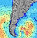 | 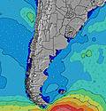 | 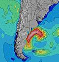 | 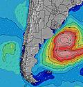 | 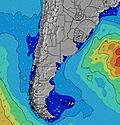 | |||||||||||||
Wave Height (m) Direction Period (s) | ESE 10 | ESE 10 | E 10 | ESE 11 | ESE 10 | ESE 10 | E 10 | E 10 | ESE 14 | ESE 14 | ESE 13 | ESE 13 | ESE 12 | ESE 12 | ESE 12 | ESE 11 | ESE 11 | ESE 11 | SE 10 | SE 10 | SE 10 |
Wave Graph | |||||||||||||||||||||
116 | 131 | 94 | 187 | 370 | 520 | 346 | 294 | 289 | 395 | 303 | 238 | 175 | 161 | 218 | 69 | 46 | 45 | 27 | 26 | 26 | |
Wind (km/h) | |||||||||||||||||||||
Wind State on-shore cross-onshore cross-shore cross-offshore off-shore glassy | off | on | on | on | cross-on | cross-on | cross | cross-off | cross-off | cross-off | cross-off | cross | cross | cross-off | cross-off | cross-off | cross-off | off | off | cross-off | off |
High Tide | 1:21AM1.40m | 2:07PM1.25m | 2:26AM1.30m | 3:03PM1.38m | 3:36AM1.20m | 3:59PM1.51m | 4:45AM1.13m | 4:56PM1.64m | 5:51AM1.09m | 5:51PM1.76m | 6:51AM1.05m | 6:46PM1.85m | 7:49AM1.03m | ||||||||
Low Tide | 8:32AM0.55m | 8:48PM0.64m | 9:06AM0.60m | 10:12PM0.56m | 9:39AM0.66m | 11:35PM0.45m | 10:14AM0.70m | 00:49AM0.33m | 10:58AM0.72m | 1:53AM0.22m | 12:05PM0.73m | 2:51AM0.13m | 1:25PM0.71m | ||||||||
— | 8:04 | — | — | 8:04 | — | — | 8:04 | — | — | 8:03 | — | — | 8:03 | — | — | 8:03 | — | — | 8:03 | — | |
— | — | 5:45 | — | — | 5:45 | — | — | 5:45 | — | — | 5:46 | — | — | 5:46 | — | — | 5:47 | — | — | 5:49 | |
mm | — | — | — | — | — | — | 2 | 1 | — | — | — | — | — | — | — | — | — | — | — | — | — |
Temp °C | 14 | 10 | 9 | 8 | 8 | 9 | 10 | 10 | 11 | 11 | 11 | 10 | 10 | 8 | 10 | 8 | 11 | 13 | 12 | 13 | 15 |
Feels °C | 11 | 6 | 5 | 2 | 3 | 4 | 6 | 5 | 6 | 7 | 6 | 4 | 5 | 5 | 6 | 3 | 3 | 7 | 7 | 10 | 12 |
Swell 1 Height (m) Direction Period (s) | ESE 10 | ESE 10 | E 10 | ESE 11 | S 7 | ESE 10 | E 10 | E 10 | ESE 14 | ESE 14 | ESE 13 | ESE 13 | ESE 12 | ESE 12 | ESE 12 | ESE 7 | E 7 | ESE 11 | NE 6 | SE 10 | ENE 7 |
116 | 131 | 94 | 187 | 32 | 520 | 346 | 294 | 289 | 395 | 303 | 238 | 175 | 161 | 218 | 47 | 36 | 45 | 23 | 26 | 21 | |
Swell 2 Height (m) Direction Period (s) | SW 5 | S 11 | ESE 12 | SSW 9 | SSW 6 | SSW 7 | SSE 8 | SSE 8 | ESE 10 | SSE 8 | SE 8 | SE 7 | SE 7 | ESE 7 | S 9 | ESE 11 | ESE 11 | ESE 7 | SE 10 | NE 6 | SE 10 |
4 | 2 | 85 | 16 | 12 | 11 | 50 | 37 | 100 | 43 | 31 | 43 | 33 | 42 | 14 | 69 | 46 | 16 | 27 | 5 | 26 | |
Swell 3 Height (m) Direction Period (s) | — | S 15 | S 10 | — | ESE 14 | S 9 | SSW 8 | ESE 15 | SSE 7 | SSW 9 | S 13 | S 12 | ENE 7 | SW 5 | SSW 4 | S 8 | S 8 | S 8 | ESE 7 | E 7 | SW 5 |
— | 4 | 8 | — | 36 | 7 | 22 | 172 | 37 | 16 | 30 | 26 | 9 | 6 | 2 | 12 | 12 | 5 | 9 | 8 | 4 | |
Wind waves Height (m) Direction Period (s) | — | S 2 | SSE 4 | SE 6 | ESE 10 | — | — | NE 4 | NE 4 | NNE 5 | WSW 5 | SW 4 | S 4 | — | — | NNE 4 | N 5 | N 5 | NW 3 | W 3 | — |
— | 2 | 23 | 104 | 370 | — | — | 20 | 23 | 33 | 36 | 13 | 12 | — | — | 22 | 76 | 62 | 3 | 2 | — | |
Nearest Offshore or Glassy | |||||||||||||||||||||
Distance (km) | 0 | 151 | 456 | 492 | 110 | 576 | 2 | 2 | 2 | 3 | 4 | 191 | 111 | 0 | 2 | 431 | 423 | 109 | 0 | 430 | 0 |
Best forecast wave conditions in Provincia de Buenos Aires | |||||||||||||||||||||
Best forecast wave conditions in Argentina | |||||||||||||||||||||
Header Global | |||||||||||||||||||||
- Map Icons:
 Break
Break Live Wave Height (m)
 Live Wind Speed (km/h)
 Surf Rating (10 Max)
 Ocean Swells (m)
- Wind Speed (km/h)


FREE! Surf-Forecast.com widget for your website
The surf report / weather widget below is available to embed on third party websites free of charge and provides a summary of our Tamarindo Playa Serena (Mar del Plata) surf forecast. Simply grab the html code snippet that we provide and paste it into your own site. You can choose your preferred language and metric/imperial units for the surf forecast feed to suit users of your site. Click here to get the code.
Information about the Tamarindo Playa Serena (Mar del Plata) Surf forecast
The above surf forecast table for Tamarindo Playa Serena (Mar del Plata) provides essential information for determining whether the surfing conditions will be good over the next 16 days. A general guide to surfing at Tamarindo Playa Serena (Mar del Plata) can be found by selecting the local surf guide option on the grey menu. Our Tamarindo Playa Serena (Mar del Plata) surf forecast is unique since it includes wave energy (power) that defines the real feel of the surf rather than just the height or the period. If you surf the same spot (Tamarindo Playa Serena (Mar del Plata)) regularly then make a mental note of the wave energy from the surf forecast table each time you go. Very soon you may start to choose your surf days based on the wave energy alone combined with our forecast of favourable offshore wind conditions. Our star ratings will help here and of course you will also find the usual wave height and period predictions on our surf forecasts as well as a full break down of the swell components under our advanced users option (to reveal that, click the little Einstein character under the tide times).
Further information to help with frequently asked questions about our surf forecast for Tamarindo Playa Serena (Mar del Plata) may be found under the help tab on the top menu and also by moving your mouse over the question marks on the surf forecast table itself. Please always bear in mind that the forecast is for near-shore open water and local factors at each surf break influence the actual breaking wave height, such as the beach / reef profile, water depths offshore and shelter.
Are you planning a holiday in Provincia de Buenos Aires? If you are looking for accommodation near Tamarindo Playa Serena (Mar del Plata), camping, hotels and holiday cottages in Provincia de Buenos Aires, consider staying in Mar del Plata which is 12 km (7 miles) away.
 Nearest