

Surf Forecasts:

How big are the waves at Souillac today (21 Jun):
- Morning surf: Morning surf (21 Jun, local time) - 11ft (3.5m), 10s period with SSW swell.
- Afternoon surf: Afternoon surf (21 Jun, local time) - 13ft (4.0m), 13s period with SSW swell.
- Evening surf: Evening surf (21 Jun, local time) - 13ft (4.0m), 14s period with SSW swell.
The current surf forecast for Souillac at 1AM is: 2.5m 14s primary swell from a Southwest direction and 0.4m 7s secondary swell from a East direction, 0.2m 9s secondary swell from a East-southeast direction (forecast issued at 09:00pm June 20). The wind direction is predicted to be onshore.
| Time (+04) & Date | Wave Height | Wave Period |
|---|---|---|
| Morning (21 Jun) | 11ft (3.5m) | 10s |
| Afternoon (21 Jun) | 13ft (4.0m) | 13s |
| Evening (21 Jun) | 13ft (4.0m) | 14s |
Table - waves today at Souillac. (Swell directed towards the surf break)
Updates in hr min s Forecast update imminent
Short Range ForecastLight rain (total 8mm), mostly falling on Sat night. Warm (max 23°C on Sat night, min 21°C on Sat night). Mainly fresh winds. | ||||||||||||||||||||||||
Sat 20 | Sunday 21 | Monday 22 | Tuesday 23 | |||||||||||||||||||||
7 PM | 10 PM | 1 AM | 4 AM | 7 AM | 10 AM | 1 PM | 4 PM | 7 PM | 10 PM | 1 AM | 4 AM | 7 AM | 10 AM | 1 PM | 4 PM | 7 PM | 10 PM | 1 AM | 4 AM | 7 AM | 10 AM | 1 PM | 4 PM | |
Swell Height Map |  | 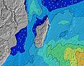 | 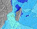 | 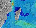 | 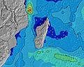 | 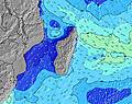 | 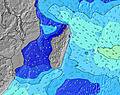 | 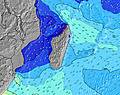 | 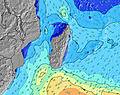 | |||||||||||||||
Wave Height (m) Direction Period (s) | SSW 14 | SSW 14 | SW 14 | SSW 8 | SSW 9 | SSW 11 | SSW 13 | SSW 13 | SSW 13 | SSW 14 | SSW 14 | SSW 14 | SSW 14 | SSW 14 | SSW 13 | SSW 13 | SSW 13 | SW 13 | S 12 | S 12 | S 12 | SSE 11 | SSE 12 | SSE 12 |
Wave Graph | ||||||||||||||||||||||||
1672 | 1447 | 2415 | 1497 | 1875 | 2970 | 5220 | 5620 | 5707 | 6151 | 6518 | 6183 | 5868 | 5164 | 4665 | 4549 | 4176 | 1912 | 1717 | 1522 | 1365 | 1187 | 1513 | 1462 | |
Wind (km/h) | ||||||||||||||||||||||||
Wind State on-shore cross-onshore cross-shore cross-offshore off-shore glassy | cross-off | cross | on | on | on | on | on | on | on | cross-on | cross-on | cross-on | cross-on | cross-on | cross-on | cross-on | cross-on | cross-on | cross-on | cross-on | cross-on | cross | cross-on | cross-on |
High Tide | 5:00PM0.59m | 4:37AM0.61m | 5:57PM0.57m | 5:42AM0.54m | 7:06PM0.57m | 7:22AM0.50m | ||||||||||||||||||
Low Tide | 10:45PM0.34m | 11:23AM0.25m | 00:01AM0.37m | 12:22PM0.30m | 1:39AM0.36m | 1:35PM0.34m | ||||||||||||||||||
— | — | — | 6:43 | — | — | — | — | — | — | — | 6:45 | — | — | — | — | — | — | — | 6:45 | — | — | — | — | |
— | — | — | — | — | — | — | 5:37 | — | — | — | — | — | — | — | 5:37 | — | — | — | — | — | — | — | 5:37 | |
mm | — | — | 4 | 1 | — | — | — | — | — | — | — | — | — | — | — | — | — | — | — | — | 1 | 1 | 1 | — |
Temp °C | 23 | 23 | 21 | 22 | 22 | 21 | 21 | 21 | 21 | 21 | 21 | 21 | 21 | 22 | 22 | 22 | 21 | 21 | 21 | 21 | 22 | 23 | 23 | 23 |
Feels °C | 21 | 21 | 18 | 17 | 17 | 15 | 15 | 16 | 17 | 18 | 18 | 17 | 17 | 18 | 19 | 17 | 17 | 17 | 19 | 20 | 20 | 21 | 21 | 21 |
Swell 1 Height (m) Direction Period (s) | SSW 14 | SSW 14 | E 7 | E 8 | SW 16 | SW 16 | E 8 | E 10 | SSW 13 | SSW 14 | SSW 14 | SSW 14 | SSW 14 | SSW 14 | SSW 13 | SSW 13 | SSW 13 | S 12 | S 12 | S 12 | SW 13 | SSE 11 | SSE 12 | SSE 12 |
1672 | 1447 | 17 | 10 | 573 | 496 | 12 | 17 | 5707 | 6151 | 6518 | 6183 | 5868 | 5164 | 4665 | 4549 | 4176 | 1665 | 1717 | 1522 | 1185 | 1187 | 1513 | 1462 | |
Swell 2 Height (m) Direction Period (s) | E 7 | SW 18 | ESE 9 | ESE 9 | E 8 | E 8 | ESE 8 | ESE 8 | E 10 | E 10 | E 10 | E 10 | E 10 | E 10 | E 10 | E 10 | E 10 | SW 13 | SW 13 | SW 13 | SSE 15 | SW 12 | SW 12 | SW 13 |
27 | 154 | 8 | 8 | 10 | 12 | 7 | 6 | 17 | 18 | 18 | 31 | 31 | 31 | 30 | 31 | 30 | 1912 | 1583 | 1185 | 228 | 1043 | 824 | 629 | |
Swell 3 Height (m) Direction Period (s) | SW 18 | E 7 | ESE 9 | — | ESE 9 | ESE 8 | — | — | — | — | — | — | — | — | — | — | SSE 16 | E 10 | SSE 16 | SSE 16 | E 10 | SSE 14 | SSW 24 | SSW 23 |
80 | 16 | 8 | — | 8 | 7 | — | — | — | — | — | — | — | — | — | — | 51 | 30 | 201 | 357 | 29 | 331 | 184 | 408 | |
Wind waves Height (m) Direction Period (s) | WNW 4 | W 4 | SW 14 | SSW 8 | SSW 9 | SSW 11 | SSW 13 | SSW 13 | — | — | — | — | — | — | — | — | — | — | — | — | S 12 | — | — | — |
11 | 38 | 2415 | 1497 | 1875 | 2970 | 5220 | 5620 | — | — | — | — | — | — | — | — | — | — | — | — | 1365 | — | — | — | |
Nearest Offshore or Glassy | ||||||||||||||||||||||||
Distance (km) | 19 | 19 | 1769 | 196 | 196 | 196 | 196 | 196 | 27 | 27 | 16 | 16 | 16 | 16 | 16 | 49 | 49 | 49 | 16 | 16 | 16 | 25 | 49 | 49 |
Best forecast wave conditions in Mauritius | ||||||||||||||||||||||||
Best forecast wave conditions in Mauritius | ||||||||||||||||||||||||
Header Global | ||||||||||||||||||||||||
- Map Icons:
 Break
Break Live Wave Height (m)
 Live Wind Speed (km/h)
 Surf Rating (10 Max)
 Ocean Swells (m)
- Wind Speed (km/h)


FREE! Surf-Forecast.com widget for your website
The surf report / weather widget below is available to embed on third party websites free of charge and provides a summary of our Souillac surf forecast. Simply grab the html code snippet that we provide and paste it into your own site. You can choose your preferred language and metric/imperial units for the surf forecast feed to suit users of your site. Click here to get the code.
 Nearest