

Surf Forecasts:

Las Urracas surf forecast from 3 Aug 2026:
- Best quality surf: Thursday 6 Aug, 5PM (local time) - 3.5ft (1.1m), 16s period, SW swell with glassy winds.
- Most powerful swell: Thursday 6 Aug, 8PM (local time) - 6ft (1.8m), 16s period, SW swell with 1,643 kJ wave energy.
- Next surfable swell (1★+): Monday 3 Aug, 5PM (local time) - 4.5ft (1.4m), 13s period with SW swell.
Best Forecast Surf Conditions for Las Urracas this week:
The surf forecast for Las Urracas over the next 16 days: The first swell (rated 1 star or higher) is forecast to arrive on Monday (Aug 03) at 5PM. The primary swell is predicted to be 1.4m and 13s period with a secondary swell of 0.3m and 12s. The wind is predicted to be glassy as the swell arrives.
The most powerful waves expected at Las Urracas in the next 16 days are 1.8m 16s and forecast to arrive on Thursday (Aug 06) at 8PM. Winds are predicted to be cross-onshore at the time the swell arrives.
| Wave Type | Time (-04) & Date | Wave Height & Period |
|---|---|---|
| Next good surf (1 star+) | 5PM (Mon 3rd Aug) | 4.5ft (1.4m) 13s |
| Best Surf | 5PM (Thu 6th Aug) | 3.5ft (1.1m) 16s |
| Most Powerful | 8PM (Thu 6th Aug) | 6ft (1.8m) 16s |
Table - best surf conditions forecast for Las Urracas over the next 16 days.
The Lowdown
Alright folks, Rusty here. Let’s have a look at what’s coming down the line for Las Urracas over the next couple of weeks.
We’ve got a real mixed bag on the cards. The outlook kicks off with a bit of a wait, but once it gets going, there’s some proper magic in the water. The early part of the week is a bit of a non-starter, but hang tight, because from Monday afternoon, the stars start to align.
The first real chance to get wet comes on Monday afternoon, August 3rd. The breeze drops to nothing, going glassy, and a solid groundswell from the SW at 5ft with a long 13-second period rolls in. The combined energy is moderate at 684, and it’s going to be clean as a whistle. That’s your first window.
Tuesday, August 4th, is a beauty. The swell holds at 5ft from the SW, with a 12-second period, and both morning and afternoon are glassy. The energy is ramping up (739 in the morning, 755 in the afternoon). This is that classic, clean, consistent reef-break goodness. The water is sitting at 66°, which is a solid 4° warmer than normal for this time of year – seriously unusual, you’ll barely need a spring suit.
Wednesday, August 5th, is more of the same perfection. Waves at 5ft, SW, 12 seconds, and glassy all day. The combined energy hits 827 in the morning – that’s a proper push. This is the kind of day where you’ll be kicking yourself if you’re stuck at work.
Thursday, August 6th, gets a little tricky in the morning with a light cross-on breeze, but hold on for the afternoon. The wind drops to glass, the swell is 4ft but the period stretches out to a very long 16 seconds, and the energy jumps to a strong 1227. This is a proper groundswell, and it’ll be bending beautifully around the reef. It’s getting a bit sizey for beginners, but for the experienced crew, this is a standout.
Friday, August 7th, is another glassy gem. The morning is clean with 4ft, 14-second SW swell, and the afternoon goes dead calm with the wind at 0 mph and 5ft waves. Energy is in the 900s. Just beautiful.
We hit a bit of a lull over the weekend and into early next week, with the wind picking up and the quality dropping. There’s a bump of bigger swell (6ft) on Monday, August 10th, but it’s choppy and cross-on – more of a kite-surfing proposition than a clean paddle session.
The real standout in the second week is Tuesday, August 11th. The afternoon goes completely glassy, dead calm, with a 6ft SW swell and a solid 13-second period. The combined energy is a massive 1427. This is excellent, powerful surf for experienced surfers only. Size is up there, and that reef will be working hard.
The following week starts to fade. There’s a glimpse of hope on Thursday, August 13th, when the afternoon turns glassy again with a tiny 2ft swell but a very long 18-second period. Energy is 731. It’ll be small but clean and perfect for a longboard.
Then, another big pulse shows up on Monday, August 17th. The morning is glassy, with 6ft, 14-second SW swell and a combined energy of 1476. That’s a strong, powerful swell. The afternoon gets a bit messy with a cross-on breeze, but that morning window is a serious contender for the best of the whole run.
Best on Offer: The clear winner is the afternoon of Thursday, August 6th, for that beautiful long-period groundswell and glassy conditions. The very close second is the morning of Monday, August 17th, for raw power and clean conditions. Tuesday, August 11th afternoon is also a beast.
Keep in mind, this is a reef setup, so it handles the long-period swells better than a beach break would. Crowds are always a possibility here, so get out early.
Rusty.
Short Range ForecastMostly dry. Warm (max 20°C on Wed morning, min 16°C on Mon night). Wind will be generally light. | Days 4-6 Weather SummaryMostly dry. Very mild (max 19°C on Thu morning, min 15°C on Fri night). Wind will be generally light. | ||||||||||||||||||||
Monday 3 | Tuesday 4 | Wednesday 5 | Thursday 6 | Friday 7 | Saturday 8 | Sunday 9 | |||||||||||||||
AM | PM | Night | AM | PM | Night | AM | PM | Night | AM | PM | Night | AM | PM | Night | AM | PM | Night | AM | PM | Night | |
Swell Height Map |  |  | 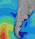 | 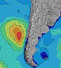 | 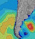 | 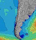 |  | ||||||||||||||
Wave Height (m) Direction Period (s) | SW 10 | SW 13 | SW 12 | SW 12 | SW 12 | SW 12 | SW 12 | SW 12 | SW 12 | SW 13 | SW 16 | SW 14 | SW 14 | SW 13 | SW 13 | SW 10 | SW 10 | SW 10 | SW 9 | SW 9 | SW 13 |
Wave Graph | |||||||||||||||||||||
154 | 653 | 827 | 736 | 736 | 748 | 761 | 689 | 614 | 581 | 635 | 1393 | 726 | 919 | 878 | 377 | 269 | 269 | 360 | 353 | 444 | |
Wind (km/h) | |||||||||||||||||||||
Wind State on-shore cross-onshore cross-shore cross-offshore off-shore glassy | cross-on | glassy | cross-off | glassy | glassy | glassy | glassy | glassy | cross-on | cross-on | glassy | cross-on | glassy | glassy | glassy | cross-on | cross-on | glassy | on | cross-on | cross |
High Tide | 12:04PM1.19m | 00:53AM1.03m | 12:42PM1.10m | 1:42AM1.07m | 1:27PM1.01m | 2:41AM1.12m | 2:25PM0.91m | 3:47AM1.17m | 3:41PM0.84m | 4:57AM1.25m | 5:07PM0.81m | 6:02AM1.33m | 6:24PM0.82m | ||||||||
Low Tide | 6:41PM0.36m | 6:39AM0.53m | 7:14PM0.38m | 7:42AM0.57m | 7:53PM0.40m | 9:03AM0.59m | 8:41PM0.41m | 10:36AM0.57m | 9:42PM0.42m | 12:01PM0.51m | 10:51PM0.40m | 1:08PM0.43m | 11:58PM0.37m | ||||||||
7:09 | — | — | 7:09 | — | — | 7:07 | — | — | 7:07 | — | — | 7:07 | — | — | 7:05 | — | — | 7:05 | — | — | |
— | 6:23 | — | — | 6:23 | — | — | 6:23 | — | — | 6:24 | — | — | 6:24 | — | — | 6:24 | — | — | 6:25 | — | |
mm | — | — | — | — | — | — | — | — | — | — | — | — | — | — | — | — | — | — | — | — | — |
Temp °C | 19 | 19 | 17 | 18 | 18 | 18 | 20 | 20 | 18 | 19 | 19 | 17 | 18 | 19 | 16 | 18 | 18 | 16 | 18 | 18 | 17 |
Feels °C | 19 | 19 | 17 | 18 | 18 | 19 | 21 | 20 | 18 | 18 | 18 | 17 | 18 | 19 | 16 | 17 | 17 | 16 | 17 | 17 | 17 |
Swell 1 Height (m) Direction Period (s) | SW 10 | SW 13 | SW 12 | SW 12 | SW 12 | SW 12 | SW 12 | SW 12 | SW 12 | SW 13 | SW 12 | SW 14 | SW 14 | SW 13 | SW 13 | SW 10 | SW 10 | SW 10 | SW 9 | SW 9 | SW 10 |
154 | 653 | 827 | 736 | 736 | 748 | 761 | 689 | 614 | 581 | 590 | 1393 | 726 | 919 | 878 | 377 | 269 | 269 | 360 | 353 | 384 | |
Swell 2 Height (m) Direction Period (s) | SSW 12 | SSW 12 | W 12 | W 12 | SW 20 | SSW 21 | SW 20 | SW 19 | SW 18 | SW 16 | SW 16 | W 11 | SW 9 | — | SW 19 | SW 13 | SW 12 | SW 12 | SW 15 | SW 14 | SW 13 |
123 | 28 | 3 | 3 | 16 | 42 | 60 | 131 | 307 | 421 | 635 | 2 | 197 | — | 14 | 156 | 175 | 132 | 301 | 273 | 444 | |
Swell 3 Height (m) Direction Period (s) | WSW 12 | W 12 | — | — | W 12 | W 11 | NW 12 | W 12 | W 12 | W 11 | W 11 | — | — | — | — | SW 18 | SW 16 | SW 16 | SW 11 | SW 20 | SW 18 |
60 | 3 | — | — | 3 | 2 | 6 | 3 | 3 | 2 | 2 | — | — | — | — | 49 | 94 | 155 | 19 | 239 | 203 | |
Wind waves Height (m) Direction Period (s) | — | — | — | — | — | — | — | — | — | — | — | — | — | — | — | — | — | — | — | — | — |
— | — | — | — | — | — | — | — | — | — | — | — | — | — | — | — | — | — | — | — | — | |
Nearest Offshore or Glassy | |||||||||||||||||||||
Distance (km) | 1 | 0 | 0 | 0 | 0 | 0 | 0 | 0 | 1 | 1 | 0 | 0 | 0 | 0 | 0 | 1 | 1 | 0 | 1 | 1 | 1 |
Best forecast wave conditions in Tarapaca | |||||||||||||||||||||
Best forecast wave conditions in Chile | |||||||||||||||||||||
Header Global | |||||||||||||||||||||
- Map Icons:
 Break
Break Live Wave Height (m)
 Live Wind Speed (km/h)
 Surf Rating (10 Max)
 Ocean Swells (m)
- Wind Speed (km/h)
Latest Updates


FREE! Surf-Forecast.com widget for your website
The surf report / weather widget below is available to embed on third party websites free of charge and provides a summary of our Las Urracas surf forecast. Simply grab the html code snippet that we provide and paste it into your own site. You can choose your preferred language and metric/imperial units for the surf forecast feed to suit users of your site. Click here to get the code.
Information about the Las Urracas Surf forecast
The above surf forecast table for Las Urracas provides essential information for determining whether the surfing conditions will be good over the next 16 days. A general guide to surfing at Las Urracas can be found by selecting the local surf guide option on the grey menu. Our Las Urracas surf forecast is unique since it includes wave energy (power) that defines the real feel of the surf rather than just the height or the period. If you surf the same spot (Las Urracas) regularly then make a mental note of the wave energy from the surf forecast table each time you go. Very soon you may start to choose your surf days based on the wave energy alone combined with our forecast of favourable offshore wind conditions. Our star ratings will help here and of course you will also find the usual wave height and period predictions on our surf forecasts as well as a full break down of the swell components under our advanced users option (to reveal that, click the little Einstein character under the tide times).
Further information to help with frequently asked questions about our surf forecast for Las Urracas may be found under the help tab on the top menu and also by moving your mouse over the question marks on the surf forecast table itself. Please always bear in mind that the forecast is for near-shore open water and local factors at each surf break influence the actual breaking wave height, such as the beach / reef profile, water depths offshore and shelter.
Are you planning a holiday in Tarapaca? If you are looking for accommodation near Las Urracas, camping, hotels and holiday cottages in Tarapaca, consider staying in Iquique which is 4 km (2 miles) away. Alternatively, find information about places to stay and car hire in Patillos which is 58 km (36 miles) away
 Nearest