

Surf Forecasts:

Faja da Areia surf forecast from 3 Aug 2026:
- Best quality surf: Monday 3 Aug, 1PM (local time) - 2.5ft (0.7m), 9s period, WNW swell with glassy winds.
- Most powerful swell: Wednesday 5 Aug, 7PM (local time) - 2.5ft (0.8m), 10s period, N swell with 122 kJ wave energy.
- Next surfable swell (1★+): Monday 3 Aug, 1PM (local time) - 2.5ft (0.7m), 9s period with WNW swell.
Best Forecast Surf Conditions for Faja da Areia this week:
The surf forecast for Faja da Areia over the next 16 days: The first swell (rated 1 star or higher) is forecast to arrive on Monday (Aug 03) at 1PM. The primary swell is predicted to be 0.7m and 9s period with a secondary swell of 0.4m and 5s. The wind is predicted to be glassy as the swell arrives.
The most powerful waves expected at Faja da Areia in the next 16 days are 0.8m 10s and forecast to arrive on Wednesday (Aug 05) at 7PM. Winds are predicted to be cross-onshore at the time the swell arrives. The largest open ocean swell (not directed at the beach) is 0.7m 10s period and expected on Thursday (Aug 06) at 4AM.
| Wave Type | Time (WEST) & Date | Wave Height & Period |
|---|---|---|
| Next good surf (1 star+) | 1PM (Mon 3rd Aug) | 2.5ft (0.7m) 9s |
| Best Surf | 1PM (Mon 3rd Aug) | 2.5ft (0.7m) 9s |
| Most Powerful | 7PM (Wed 5th Aug) | 2.5ft (0.8m) 10s |
Table - best surf conditions forecast for Faja da Areia over the next 16 days.
The Lowdown
Alright folks, Rusty here. Let’s have a look at what’s cookin’ for the next couple of weeks.
Right off the bat, we’re looking at a pretty quiet stretch. The first real surf worth mentioning doesn’t show up until Monday, August 3rd, and even then it’s tiny. We’re talkin’ ankle-biters. The overall pattern is one of small, inconsistent, and mostly poor surf through the first week, with a few windows of clean, glassy conditions that will make the most of what little we have.
Monday, August 3rd kicks it off with a dead calm morning at Faja da Areia. The swell is a tiny 1.0ft from the north, with a period of 9 seconds. The combined energy is a weak 17. It’s glassy, but honestly, you’re just floating around. The afternoon sees a slight bump to 2ft from the WNW, still glassy, but the energy only ticks up to 88. It’s surfable, but very ordinary.
Tuesday, August 4th is more of the same, with 3ft waves from the WNW in the morning (energy 99) and 2ft in the afternoon, both with glassy wind. It’s not gonna blow your mind, but it’s clean enough for a log.
Wednesday, August 5th is the first real standout. The morning brings a 3ft swell from the WNW, but the period stretches to 10 seconds and the energy jumps to 182. The wind is light and glassy. This is the best of the first week. The afternoon turns a little cross-on, which takes the shine off.
Thursday, August 6th through Sunday, August 9th are mostly a write-off. The wind swings cross or cross-onshore, and the swell drops. The mornings of the 8th and 9th offer a few small, clean windows, but the energy is moderate at best.
After a flat spell on Monday, August 10th and Tuesday morning, August 11th, we get a surprise. Tuesday afternoon, August 11th sees a jump to 3ft from the WNW with a long period of 10 seconds, and the energy hits 202. The wind is glassy. For a spot that’s inconsistent, this is a proper little window of clean, fun surf. This is the clear standout of the whole period.
The second week gets a bit messy. Wednesday, August 12th through Sunday, August 16th is mostly poor, with onshore winds and small wave heights. The energy is weak. There’s a bump on Sunday, August 16th with 4ft to 4ft from the NNE, but the cross-onshore wind ruins it. Monday, August 17th and Tuesday, August 18th are similar – small, messy, and cross-on. The surf is up a little, but the quality just isn’t there.
So, to wrap it up: if you’re keen, you’ve got a couple of decent windows. Wednesday morning, August 5th is your best bet early on for a little glassy bump. But the real winner is Tuesday afternoon, August 11th – that’s the one to circle on the calendar. It’s a far-off call, but with a clean 3ft groundswell from the WNW and glassy conditions, Faja da Areia could be real fun for a few hours. The rest of the time, it’s a case of watch the forecast and hope for a change.
Rusty.
Short Range ForecastMostly dry. Warm (max 29°C on Mon morning, min 22°C on Wed night). Wind will be generally light. | Days 4-6 Weather SummaryMostly dry. Warm (max 29°C on Fri morning, min 21°C on Sat night). Wind will be generally light. | ||||||||||||||||||||
Monday 3 | Tuesday 4 | Wednesday 5 | Thursday 6 | Friday 7 | Saturday 8 | Sunday 9 | |||||||||||||||
AM | PM | Night | AM | PM | Night | AM | PM | Night | AM | PM | Night | AM | PM | Night | AM | PM | Night | AM | PM | Night | |
Swell Height Map |  |  | 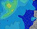 | 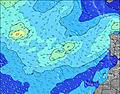 | 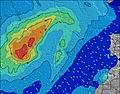 | 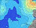 | 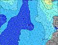 | ||||||||||||||
Wave Height (m) Direction Period (s) | N 9 | WNW 9 | WNW 8 | WNW 8 | WNW 8 | WNW 9 | WNW 10 | WNW 10 | N 10 | N 10 | N 9 | N 9 | N 9 | N 9 | N 10 | N 10 | N 10 | N 10 | N 9 | NW 7 | NW 7 |
Wave Graph | |||||||||||||||||||||
13 | 70 | 92 | 88 | 58 | 96 | 120 | 107 | 115 | 117 | 110 | 109 | 80 | 104 | 118 | 116 | 92 | 65 | 43 | 51 | 35 | |
Wind (km/h) | |||||||||||||||||||||
Wind State on-shore cross-onshore cross-shore cross-offshore off-shore glassy | glassy | glassy | cross-on | glassy | glassy | cross-on | cross-on | on | cross-on | cross-on | cross-on | cross-on | cross-on | cross-on | glassy | glassy | on | glassy | on | glassy | glassy |
High Tide | 5:43PM2.02m | 6:09AM1.84m | 6:25PM1.91m | 6:56AM1.76m | 7:17PM1.79m | 7:56AM1.68m | 8:26PM1.67m | 9:13AM1.64m | 9:54PM1.62m | 10:40AM1.69m | 11:22PM1.68m | 11:56AM1.84m | 00:33AM1.80m | ||||||||
Low Tide | 11:27AM0.31m | 11:57PM0.29m | 12:08PM0.40m | 00:40AM0.38m | 12:58PM0.49m | 1:34AM0.48m | 2:04PM0.59m | 2:44AM0.57m | 3:30PM0.62m | 4:12AM0.59m | 5:04PM0.55m | 5:34AM0.52m | 6:20PM0.39m | ||||||||
7:22 | — | — | 7:22 | — | — | 7:24 | — | — | 7:24 | — | — | 7:24 | — | — | 7:26 | — | — | 7:26 | — | — | |
— | — | 9:05 | — | — | 9:04 | — | — | 9:02 | — | — | 9:01 | — | — | 9:00 | — | — | 9:00 | — | — | 9:00 | |
mm | — | — | — | — | — | — | — | — | — | — | — | — | — | — | — | — | — | — | — | — | — |
Temp °C | 29 | 29 | 24 | 29 | 29 | 25 | 28 | 28 | 23 | 27 | 27 | 22 | 29 | 29 | 23 | 28 | 28 | 23 | 26 | 25 | 21 |
Feels °C | 33 | 33 | 27 | 33 | 34 | 28 | 31 | 31 | 26 | 29 | 29 | 23 | 31 | 32 | 24 | 31 | 31 | 27 | 29 | 29 | 24 |
Swell 1 Height (m) Direction Period (s) | WNW 9 | WNW 9 | WNW 8 | WNW 8 | WNW 8 | WNW 9 | WNW 10 | WNW 10 | N 10 | N 10 | N 9 | N 9 | N 9 | ENE 6 | ENE 6 | N 10 | N 10 | N 10 | N 9 | N 9 | NW 7 |
66 | 70 | 92 | 88 | 58 | 96 | 120 | 107 | 115 | 117 | 110 | 109 | 80 | 78 | 51 | 116 | 92 | 65 | 39 | 24 | 35 | |
Swell 2 Height (m) Direction Period (s) | N 9 | NE 5 | NNE 6 | N 8 | WNW 10 | NNW 10 | N 11 | N 10 | WNW 10 | WNW 9 | WNW 9 | WNW 9 | WNW 9 | N 9 | N 10 | NE 6 | NE 6 | ENE 6 | NE 6 | NE 6 | N 8 |
13 | 6 | 3 | 6 | 34 | 10 | 59 | 98 | 105 | 66 | 65 | 46 | 44 | 104 | 118 | 40 | 32 | 24 | 16 | 9 | 12 | |
Swell 3 Height (m) Direction Period (s) | NE 5 | N 8 | N 8 | NNE 6 | N 8 | NNW 8 | NNW 7 | E 6 | ESE 6 | S 13 | S 12 | S 12 | S 12 | WNW 9 | WNW 8 | WNW 8 | WNW 8 | WNW 8 | N 12 | NNW 11 | NE 5 |
4 | 12 | 5 | 4 | 6 | 6 | 5 | 2 | 6 | 3 | 3 | 3 | 3 | 44 | 39 | 22 | 26 | 32 | 11 | 11 | 7 | |
Wind waves Height (m) Direction Period (s) | NNW 3 | — | — | E 4 | — | — | ENE 6 | — | NNE 3 | NE 4 | ENE 5 | ENE 6 | ENE 6 | — | — | — | — | NW 4 | NW 7 | NW 7 | N 4 |
1 | — | — | 1 | — | — | 6 | — | 4 | 20 | 27 | 55 | 73 | — | — | — | — | 7 | 43 | 51 | 4 | |
Nearest Offshore or Glassy | |||||||||||||||||||||
Distance (km) | 14 | 7 | 0 | 9 | 0 | 0 | 0 | 0 | 14 | 14 | 14 | 14 | 14 | 15 | 15 | 0 | 0 | 15 | 0 | 0 | 484 |
Best forecast wave conditions in Madeira | |||||||||||||||||||||
Best forecast wave conditions in Portugal | |||||||||||||||||||||
Header Global | |||||||||||||||||||||
- Map Icons:
 Break
Break Live Wave Height (m)
 Live Wind Speed (km/h)
 Surf Rating (10 Max)
 Ocean Swells (m)
- Wind Speed (km/h)
Latest Updates


FREE! Surf-Forecast.com widget for your website
The surf report / weather widget below is available to embed on third party websites free of charge and provides a summary of our Faja da Areia surf forecast. Simply grab the html code snippet that we provide and paste it into your own site. You can choose your preferred language and metric/imperial units for the surf forecast feed to suit users of your site. Click here to get the code.
Information about the Faja da Areia Surf forecast
The above surf forecast table for Faja da Areia provides essential information for determining whether the surfing conditions will be good over the next 16 days. A general guide to surfing at Faja da Areia can be found by selecting the local surf guide option on the grey menu. Our Faja da Areia surf forecast is unique since it includes wave energy (power) that defines the real feel of the surf rather than just the height or the period. If you surf the same spot (Faja da Areia) regularly then make a mental note of the wave energy from the surf forecast table each time you go. Very soon you may start to choose your surf days based on the wave energy alone combined with our forecast of favourable offshore wind conditions. Our star ratings will help here and of course you will also find the usual wave height and period predictions on our surf forecasts as well as a full break down of the swell components under our advanced users option (to reveal that, click the little Einstein character under the tide times).
Further information to help with frequently asked questions about our surf forecast for Faja da Areia may be found under the help tab on the top menu and also by moving your mouse over the question marks on the surf forecast table itself. Please always bear in mind that the forecast is for near-shore open water and local factors at each surf break influence the actual breaking wave height, such as the beach / reef profile, water depths offshore and shelter.
Faja da Areia is 21 km (13 miles) from the city of Camara de Lobos. If you plan a holiday in Madeira, look for hotels and other accommodation in Camara de Lobos. Camara de Lobos has rooms for a wide range of budgets as well as car hire and transport links.
 Nearest