

Surf Forecasts:

How big are the waves at Cupecoy today (30 Jun):
- Afternoon surf: Afternoon surf (30 Jun, local time) - 0.5ft (0.1m), 12s period with N swell.
- Evening surf: Evening surf (30 Jun, local time) - 0.5ft (0.1m), 12s period with N swell.
The current surf forecast for Cupecoy at 8PM is: 0.1m 12s primary swell from a North direction (forecast issued at 01:00pm June 30). An open ocean swell of 1.4m 8s is not directed at the surf break. The wind direction is predicted to be cross-offshore.
| Time (AST) & Date | Wave Height | Wave Period |
|---|---|---|
| Morning (30 Jun) | - | - |
| Afternoon (30 Jun) | 0.5ft (0.1m) | 12s |
| Evening (30 Jun) | 0.5ft (0.1m) | 12s |
Table - waves today at Cupecoy. (Swell directed towards the surf break)
Updates in hr min s Forecast update imminent
Short Range ForecastMostly dry. Warm (max 27°C on Tue afternoon, min 26°C on Tue night). Mainly fresh winds. | ||||||||||||||||||||||||
Tue 30 | Wednesday 1 | Thursday 2 | Fri 3 | |||||||||||||||||||||
11 AM | 2 PM | 5 PM | 8 PM | 11 PM | 2 AM | 5 AM | 8 AM | 11 AM | 2 PM | 5 PM | 8 PM | 11 PM | 2 AM | 5 AM | 8 AM | 11 AM | 2 PM | 5 PM | 8 PM | 11 PM | 2 AM | 5 AM | 8 AM | |
Swell Height Map |  |  | 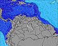 |  |  |  |  | 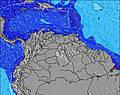 | 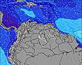 | |||||||||||||||
Wave Height (m) Direction Period (s) | E 8 | E 8 | N 12 | N 12 | N 12 | N 12 | N 11 | N 11 | N 11 | N 10 | N 10 | N 10 | N 10 | N 9 | N 9 | N 9 | N 9 | N 9 | N 9 | N 9 | N 8 | N 8 | N 8 | N 8 |
Wave Graph | ||||||||||||||||||||||||
0 | 0 | 3 | 3 | 3 | 3 | 2 | 2 | 2 | 2 | 2 | 2 | 2 | 2 | 2 | 2 | 2 | 2 | 2 | 1 | 1 | 1 | 1 | 1 | |
Wind (km/h) | ||||||||||||||||||||||||
Wind State on-shore cross-onshore cross-shore cross-offshore off-shore glassy | cross-off | cross-off | cross-off | cross-off | cross-off | cross-off | cross-off | cross-off | cross-off | cross-off | cross-off | cross-off | cross-off | cross-off | cross-off | cross-off | cross-off | cross-off | cross-off | cross-off | cross-off | cross-off | cross-off | cross-off |
High Tide | 9:45PM0.36m | 10:19PM0.37m | 10:49PM0.37m | |||||||||||||||||||||
Low Tide | 1:13PM0.02m | 1:53PM0.04m | 2:33PM0.07m | 6:31AM0.20m | ||||||||||||||||||||
— | — | — | — | — | — | 5:39 | — | — | — | — | — | — | — | 5:39 | — | — | — | — | — | — | — | 5:41 | — | |
— | — | 6:52 | — | — | — | — | — | — | — | 6:52 | — | — | — | — | — | — | — | 6:52 | — | — | — | — | 6:52 | |
mm | — | — | — | — | — | — | — | — | — | — | — | — | — | — | — | — | — | — | — | — | — | — | — | — |
Temp °C | 27 | 27 | 27 | 26 | 26 | 26 | 26 | 26 | 26 | 27 | 27 | 27 | 26 | 26 | 26 | 26 | 26 | 27 | 27 | 26 | 26 | 26 | 26 | 26 |
Feels °C | 27 | 27 | 28 | 26 | 25 | 25 | 25 | 25 | 25 | 27 | 28 | 27 | 26 | 25 | 25 | 24 | 24 | 26 | 28 | 26 | 25 | 25 | 25 | 25 |
Swell 1 Height (m) Direction Period (s) | — | — | N 12 | N 12 | N 12 | N 11 | N 11 | N 11 | N 11 | N 10 | N 10 | N 10 | N 10 | S 5 | S 5 | S 5 | S 5 | N 9 | N 9 | S 5 | S 5 | S 6 | S 6 | N 8 |
— | — | 3 | 3 | 3 | 2 | 2 | 2 | 2 | 2 | 2 | 2 | 2 | 2 | 5 | 5 | 5 | 2 | 2 | 8 | 4 | 2 | 2 | 1 | |
Swell 2 Height (m) Direction Period (s) | — | — | N 12 | N 12 | N 12 | N 12 | N 11 | N 11 | N 11 | — | N 10 | N 10 | N 10 | N 9 | N 9 | N 9 | N 9 | — | — | N 9 | N 8 | N 8 | N 8 | — |
— | — | 3 | 3 | 3 | 3 | 2 | 2 | 2 | — | 2 | 2 | 2 | 2 | 2 | 2 | 2 | — | — | 1 | 1 | 1 | 1 | — | |
Swell 3 Height (m) Direction Period (s) | — | — | — | — | — | — | — | — | — | — | — | — | — | — | — | — | — | — | — | — | — | — | — | — |
— | — | — | — | — | — | — | — | — | — | — | — | — | — | — | — | — | — | — | — | — | — | — | — | |
Wind waves Height (m) Direction Period (s) | E 8 | E 8 | E 8 | E 8 | E 8 | E 8 | E 8 | E 8 | E 8 | E 8 | E 8 | E 8 | E 8 | E 8 | E 8 | E 8 | E 8 | ESE 8 | ESE 5 | E 8 | E 8 | E 8 | E 8 | E 8 |
305 | 298 | 260 | 260 | 224 | 230 | 230 | 230 | 230 | 224 | 228 | 195 | 190 | 187 | 157 | 157 | 182 | 192 | 87 | 138 | 138 | 164 | 164 | 164 | |
Nearest Offshore or Glassy | ||||||||||||||||||||||||
Distance (km) | 890 | 298 | 38 | 298 | 330 | 330 | 306 | 298 | 298 | 925 | 38 | 38 | 298 | 306 | 298 | 417 | 925 | 298 | 298 | 155 | 415 | 576 | 576 | 298 |
Best forecast wave conditions in Netherlands-Antilles - Saint Martin | ||||||||||||||||||||||||
Best forecast wave conditions in Netherlands Antilles | ||||||||||||||||||||||||
Header Global | ||||||||||||||||||||||||
- Map Icons:
 Break
Break Live Wave Height (m)
 Live Wind Speed (km/h)
 Surf Rating (10 Max)
 Ocean Swells (m)
- Wind Speed (km/h)


FREE! Surf-Forecast.com widget for your website
The surf report / weather widget below is available to embed on third party websites free of charge and provides a summary of our Cupecoy surf forecast. Simply grab the html code snippet that we provide and paste it into your own site. You can choose your preferred language and metric/imperial units for the surf forecast feed to suit users of your site. Click here to get the code.
 Nearest