

Surf Forecasts:

Club Med surf forecast from 1 Aug 2026:
- Best quality surf: Thursday 6 Aug, 12PM (local time) - 1.5ft (0.5m), 10s period, S swell with cross-offshore winds.
- Most powerful swell: Sunday 2 Aug, 12PM (local time) - 4.5ft (1.3m), 7s period, SW swell with 184 kJ wave energy.
- Next surfable swell (1★+): Thursday 6 Aug, 12PM (local time) - 1.5ft (0.5m), 10s period with S swell.
Best Forecast Surf Conditions for Club Med this week:
The surf forecast for Club Med over the next 16 days: The first swell (rated 1 star or higher) is forecast to arrive on Thursday (Aug 06) at 12PM. The primary swell is predicted to be 0.5m and 10s period. The wind is predicted to be cross-offshore as the swell arrives.
The most powerful waves expected at Club Med in the next 16 days are 1.3m 7s and forecast to arrive on Sunday (Aug 02) at 12PM. Winds are predicted to be cross-shore at the time the swell arrives. The largest open ocean swell (not directed at the beach) is 1.4m 5s period and expected on Monday (Aug 03) at 12PM.
| Wave Type | Time (GMT) & Date | Wave Height & Period |
|---|---|---|
| Next good surf (1 star+) | 12PM (Thu 6th Aug) | 1.5ft (0.5m) 10s |
| Best Surf | 12PM (Thu 6th Aug) | 1.5ft (0.5m) 10s |
| Most Powerful | 12PM (Sun 2nd Aug) | 4.5ft (1.3m) 7s |
Table - best surf conditions forecast for Club Med over the next 16 days.
The Lowdown
Right, listen up. Rusty here. Let’s have a look at what’s cooking for the Club Med reef.
To be straight with you, the next couple of weeks are looking pretty flat and ordinary. The swell energy is just not there, and the wind is mostly junk. We’ve got a long stretch of nothing happening, then a glimmer of something promising right at the end of the window.
The first real chance of a surfable wave isn't until the morning of Sunday, the 16th of August. So, yeah, we’re talking a solid two-week gap of poor-to-marginal conditions. The water temp is sitting at a warm 83°, which is pretty normal for this time of year, so at least a dip won’t be a shock.
Alright, the standout. That Sunday the 16th of August. The morning session is the one to mark. We’re looking at a 4 ft swell from the SW, and the period is a very long 16 seconds. That’s proper groundswell, with a lot of punch. The combined energy is strong at 682. The wind is light and from the West, which is a cross-shore, but the light breeze (3 mph) means it’ll be glassy and clean. For a reef break like this, that long-period swell is a dream – it’ll wrap in and give you some proper shaped waves. It’s not huge, but for how dead it’s been, this is the session. The afternoon holds similar size at 4 ft, same long period, but the wind picks up a touch and goes cross-off from the NW, which is still decent. The energy bumps up to 825, but the score drops a bit, so morning is your best bet.
Don’t get your hopes up for anything before that. The rest of the 16 days is a write-off. Swell is tiny, wind is onshore or cross-shore with chop. It’s the kind of setup that’s more interesting for kite surfing than paddle surfing, to be honest. The break is exposed and for advanced surfers, so when it’s on, it’s on. But it’s been silent for a long time.
Keep an eye on that Sunday the 16th. It’s a long way out, so the forecast could shift, but it’s the only real glimmer of hope.
Rusty.
Short Range ForecastLight rain (total 2mm), mostly falling on Sat morning. Warm (max 27°C on Sat morning, min 26°C on Sat afternoon). Mainly fresh winds. | Days 4-6 Weather SummaryMostly dry. Warm (max 27°C on Wed morning, min 26°C on Tue morning). Wind will be generally light. | ||||||||||||||||||||
Saturday 1 | Sunday 2 | Monday 3 | Tuesday 4 | Wednesday 5 | Thursday 6 | Friday 7 | |||||||||||||||
AM | PM | Night | AM | PM | Night | AM | PM | Night | AM | PM | Night | AM | PM | Night | AM | PM | Night | AM | PM | Night | |
Swell Height Map | 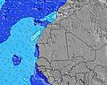 | 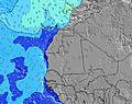 | 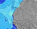 | 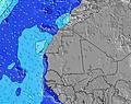 | 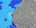 | 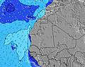 | 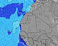 | ||||||||||||||
Wave Height (m) Direction Period (s) | SSW 13 | SSW 12 | SSW 7 | SW 7 | SW 7 | SW 7 | SSW 12 | SSW 13 | WNW 6 | SSW 12 | SSW 12 | SSW 11 | SW 11 | SSW 11 | SSW 8 | NW 11 | SSW 10 | SW 13 | SSW 12 | SSW 12 | SSW 11 |
Wave Graph | |||||||||||||||||||||
111 | 103 | 131 | 160 | 167 | 72 | 52 | 68 | 117 | 96 | 96 | 51 | 31 | 47 | 21 | 19 | 19 | 42 | 57 | 56 | 49 | |
Wind (km/h) | |||||||||||||||||||||
Wind State on-shore cross-onshore cross-shore cross-offshore off-shore glassy | on | on | cross-on | cross | cross-off | cross-off | cross-off | cross | cross | cross-on | cross-on | cross-on | on | cross-on | cross | cross-off | cross-off | cross-off | cross-off | cross-off | cross |
High Tide | 10:49AM1.32m | 11:07PM1.12m | 11:20AM1.30m | 11:42PM1.11m | 11:53AM1.26m | 00:18AM1.09m | 12:30PM1.19m | 1:00AM1.05m | 1:13PM1.10m | 1:50AM1.00m | 2:07PM1.01m | 2:55AM0.97m | 3:23PM0.93m | ||||||||
Low Tide | 5:04PM0.11m | 5:01AM0.13m | 5:37PM0.11m | 5:36AM0.16m | 6:11PM0.13m | 6:15AM0.20m | 6:49PM0.16m | 6:59AM0.25m | 7:34PM0.21m | 7:54AM0.30m | 8:29PM0.26m | 9:06AM0.34m | 9:40PM0.30m | ||||||||
6:52 | — | — | 6:52 | — | — | 6:52 | — | — | 6:52 | — | — | 6:54 | — | — | 6:54 | — | — | 6:54 | — | — | |
— | 7:38 | — | — | 7:38 | — | — | 7:38 | — | — | 7:37 | — | — | 7:37 | — | — | 7:37 | — | — | 7:37 | — | |
mm | 2 | — | — | — | — | — | — | — | — | — | — | — | — | — | — | — | — | — | — | — | — |
Temp °C | 27 | 27 | 26 | 27 | 27 | 26 | 26 | 26 | 26 | 26 | 26 | 26 | 27 | 27 | 27 | 26 | 27 | 26 | 26 | 26 | 26 |
Feels °C | 29 | 27 | 28 | 28 | 28 | 26 | 25 | 25 | 26 | 27 | 28 | 27 | 28 | 29 | 30 | 29 | 29 | 27 | 29 | 29 | 28 |
Swell 1 Height (m) Direction Period (s) | NNW 8 | NNW 8 | SSW 7 | SW 7 | SW 7 | SW 7 | SW 7 | SW 7 | N 7 | NNW 7 | NNW 6 | NW 6 | N 9 | N 9 | N 8 | N 8 | NNW 8 | N 8 | N 8 | NNW 8 | N 8 |
89 | 69 | 131 | 160 | 167 | 71 | 36 | 35 | 35 | 88 | 51 | 11 | 83 | 101 | 50 | 35 | 53 | 33 | 30 | 65 | 41 | |
Swell 2 Height (m) Direction Period (s) | SSW 13 | SSW 12 | NNW 8 | SSW 12 | NW 10 | NW 9 | NW 9 | NW 9 | SSW 13 | SSW 12 | SSW 12 | SSW 11 | NW 8 | SSW 11 | SSW 8 | SSW 7 | SSW 7 | S 7 | S 7 | S 7 | SSW 11 |
111 | 103 | 44 | 98 | 48 | 42 | 41 | 40 | 114 | 96 | 96 | 51 | 24 | 47 | 21 | 17 | 18 | 26 | 24 | 23 | 49 | |
Swell 3 Height (m) Direction Period (s) | WSW 5 | SSW 10 | SSW 13 | NNW 7 | SW 12 | SW 12 | SSW 12 | SSW 13 | NW 8 | NW 8 | N 7 | N 7 | SW 11 | NW 6 | NW 6 | NW 11 | SSW 10 | SW 13 | SSW 12 | SSW 12 | SSW 6 |
15 | 10 | 106 | 29 | 72 | 72 | 52 | 68 | 25 | 25 | 8 | 23 | 31 | 14 | 11 | 19 | 19 | 42 | 57 | 56 | 13 | |
Wind waves Height (m) Direction Period (s) | S 6 | SSW 7 | — | — | NNW 7 | NW 4 | NW 5 | NW 6 | WNW 6 | WSW 5 | WSW 5 | WSW 5 | WSW 5 | SW 5 | — | — | W 5 | NW 2 | NW 3 | WNW 3 | W 3 |
30 | 70 | — | — | 15 | 39 | 74 | 92 | 117 | 39 | 32 | 19 | 19 | 14 | — | — | 2 | 1 | 4 | 2 | 3 | |
Nearest Offshore or Glassy | |||||||||||||||||||||
Distance (km) | 1 | 624 | 611 | 611 | 611 | 611 | 612 | 643 | 644 | 644 | 611 | 611 | 611 | 1 | 611 | 613 | 611 | 612 | 0 | 0 | 611 |
Best forecast wave conditions in Senegal | |||||||||||||||||||||
Best forecast wave conditions in Senegal | |||||||||||||||||||||
Header Global | |||||||||||||||||||||
- Map Icons:
 Break
Break Live Wave Height (m)
 Live Wind Speed (km/h)
 Surf Rating (10 Max)
 Ocean Swells (m)
- Wind Speed (km/h)
Latest Updates


FREE! Surf-Forecast.com widget for your website
The surf report / weather widget below is available to embed on third party websites free of charge and provides a summary of our Club Med surf forecast. Simply grab the html code snippet that we provide and paste it into your own site. You can choose your preferred language and metric/imperial units for the surf forecast feed to suit users of your site. Click here to get the code.
Information about the Club Med Surf forecast
The above surf forecast table for Club Med provides essential information for determining whether the surfing conditions will be good over the next 16 days. A general guide to surfing at Club Med can be found by selecting the local surf guide option on the grey menu. Our Club Med surf forecast is unique since it includes wave energy (power) that defines the real feel of the surf rather than just the height or the period. If you surf the same spot (Club Med) regularly then make a mental note of the wave energy from the surf forecast table each time you go. Very soon you may start to choose your surf days based on the wave energy alone combined with our forecast of favourable offshore wind conditions. Our star ratings will help here and of course you will also find the usual wave height and period predictions on our surf forecasts as well as a full break down of the swell components under our advanced users option (to reveal that, click the little Einstein character under the tide times).
Further information to help with frequently asked questions about our surf forecast for Club Med may be found under the help tab on the top menu and also by moving your mouse over the question marks on the surf forecast table itself. Please always bear in mind that the forecast is for near-shore open water and local factors at each surf break influence the actual breaking wave height, such as the beach / reef profile, water depths offshore and shelter.
Club Med is 6 km (4 miles) from the very large city of Dakar. If you plan a holiday in Senegal, look for hotels and other accommodation in Dakar. Dakar has rooms for a wide range of budgets as well as cheap car hire and transport links.
 Nearest