

Surf Forecasts:

San Miguel - Populo surf forecast from 1 Aug 2026:
- Best quality surf: Monday 3 Aug, 3AM (local time) - 2.5ft (0.8m), 8s period, W swell with cross-offshore winds.
- Most powerful swell: Wednesday 5 Aug, 6AM (local time) - 3.5ft (1.1m), 9s period, W swell with 203 kJ wave energy.
- Next surfable swell (1★+): Monday 3 Aug, 3AM (local time) - 2.5ft (0.8m), 8s period with W swell.
Best Forecast Surf Conditions for San Miguel - Populo this week:
The surf forecast for San Miguel - Populo over the next 16 days: The first swell (rated 1 star or higher) is forecast to arrive on Monday (Aug 03) at 3AM. The primary swell is predicted to be 0.8m and 8s period. The wind is predicted to be cross-offshore as the swell arrives.
The most powerful waves expected at San Miguel - Populo in the next 16 days are 1.1m 9s and forecast to arrive on Wednesday (Aug 05) at 6AM. Winds are predicted to be cross-onshore at the time the swell arrives. The largest open ocean swell (not directed at the beach) is 1.4m 9s period and expected on Thursday (Aug 06) at 9PM.
| Wave Type | Time (+00) & Date | Wave Height & Period |
|---|---|---|
| Next good surf (1 star+) | 3AM (Mon 3rd Aug) | 2.5ft (0.8m) 8s |
| Best Surf | 3AM (Mon 3rd Aug) | 2.5ft (0.8m) 8s |
| Most Powerful | 6AM (Wed 5th Aug) | 3.5ft (1.1m) 9s |
Table - best surf conditions forecast for San Miguel - Populo over the next 16 days.
The Lowdown
Alright folks, Rusty here. Let’s be straight with you – we’ve got a long stretch ahead and not a lot to get excited about. The whole 16-day window is a tough one for San Miguel - Populo. The swell energy is mostly weak, the wind is often wrong, and the wave quality is pretty ordinary for most of it. There’s a gap at the start with no recommendations, so don’t bother paddling out until we get to Monday, August 3rd.
The water temperature is sitting at 73°F which is about normal for the time of year, so at least it’ll be comfortable while you’re sitting there waiting.
The first real chance to get wet is on Monday, August 3rd. It’s a small day – swell around 3ft from the west, with a period of 10 seconds giving it a bit of push. The combined energy is moderate at 143. What’s good is the wind: glassy in the morning, and still glassy in the afternoon. That’s a major positive. The waves are surfable, but they’re very ordinary. It’s a beginner-friendly break, and with that small size, it’s a good one for learning. Crowds are possible here, so keep an eye out.
After that, it gets messy. From Tuesday the 4th through to Friday the 14th, the wind is mostly cross-onshore, onshore, or just choppy. Swell sizes bounce between 2ft and 4ft, but the conditions are poor – too rough for clean surfing. The combined energy occasionally hits moderate levels (like 228 on Wednesday the 5th morning), but the cross-onshore wind and short period (6 seconds) chop it all up. Not worth your time.
There’s a little flicker of hope on Friday, August 14th in the afternoon. Swell is 2ft from the west, period 8 seconds, and the wind goes cross-offshore from the northwest at 15 km/h. The combined energy is weak at 75, but the surf becomes clean. It’s still small and ordinary, but the clean conditions are a nice change. That’s the best of a bad bunch.
The last couple of days, August 15th and 16th, are tiny – 0.7ft to 1ft – and glassy or offshore, but with that little energy, you’re better off on a longboard or a paddleboard.
Honestly, there’s no standout swell in this outlook. If you’re desperate, the Monday morning glass-off on August 3rd or the clean Friday afternoon on the 14th are your best bets. Otherwise, keep your gear in the shed and wait for a better forecast.
Stay tuned, hope it changes. Rusty out.
Short Range ForecastMostly dry. Warm (max 23°C on Sat morning, min 21°C on Sat night). Wind will be generally light. | Days 4-6 Weather SummaryHeavy rain (total 20mm), heaviest during Wed night. Warm (max 24°C on Tue morning, min 21°C on Wed night). Wind will be generally light. | ||||||||||||||||||||
Saturday 1 | Sunday 2 | Monday 3 | Tuesday 4 | Wednesday 5 | Thursday 6 | Friday 7 | |||||||||||||||
AM | PM | Night | AM | PM | Night | AM | PM | Night | AM | PM | Night | AM | PM | Night | AM | PM | Night | AM | PM | Night | |
Swell Height Map |  |  |  | 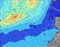 | 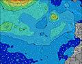 | 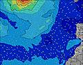 | 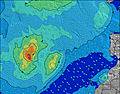 | ||||||||||||||
Wave Height (m) Direction Period (s) | W 9 | W 9 | WNW 9 | WNW 8 | W 8 | WNW 8 | W 10 | W 9 | W 10 | W 10 | W 10 | WSW 9 | W 9 | W 6 | WSW 6 | W 6 | W 6 | W 6 | W 8 | W 8 | W 8 |
Wave Graph | |||||||||||||||||||||
60 | 59 | 129 | 120 | 140 | 110 | 120 | 110 | 90 | 118 | 92 | 144 | 203 | 100 | 121 | 109 | 84 | 51 | 32 | 31 | 18 | |
Wind (km/h) | |||||||||||||||||||||
Wind State on-shore cross-onshore cross-shore cross-offshore off-shore glassy | cross-on | cross-on | cross | cross | cross | cross | glassy | glassy | glassy | on | on | cross-on | cross-on | cross-on | cross-on | cross-on | cross-on | cross-off | cross | cross | cross |
High Tide | 3:51PM1.66m | 4:15AM1.53m | 4:30PM1.63m | 4:58AM1.50m | 5:16PM1.57m | 5:48AM1.46m | 6:10PM1.50m | 6:49AM1.41m | 7:16PM1.43m | 8:02AM1.39m | 8:36PM1.39m | 9:22AM1.42m | 9:58PM1.41m | ||||||||
Low Tide | 9:34AM0.43m | 10:05PM0.40m | 10:13AM0.46m | 10:45PM0.43m | 10:57AM0.51m | 11:32PM0.49m | 11:50AM0.57m | 00:29AM0.55m | 12:57PM0.63m | 1:39AM0.60m | 2:20PM0.65m | 3:00AM0.61m | 3:47PM0.61m | ||||||||
6:45 | — | — | 6:46 | — | — | 6:47 | — | — | 6:48 | — | — | 6:48 | — | — | 6:48 | — | — | 6:50 | — | — | |
— | 8:51 | — | — | 8:50 | — | — | 8:49 | — | — | 8:47 | — | — | 8:46 | — | — | 8:45 | — | — | 8:45 | — | |
mm | — | — | — | — | — | — | — | — | — | — | 1 | — | — | 1 | 7 | 6 | 4 | 1 | — | — | — |
Temp °C | 23 | 23 | 22 | 23 | 23 | 21 | 23 | 23 | 23 | 24 | 24 | 22 | 23 | 24 | 23 | 23 | 23 | 21 | 22 | 22 | 21 |
Feels °C | 24 | 23 | 24 | 22 | 23 | 22 | 25 | 25 | 25 | 26 | 26 | 24 | 24 | 25 | 24 | 23 | 23 | 20 | 21 | 20 | 21 |
Swell 1 Height (m) Direction Period (s) | W 9 | W 9 | WNW 9 | WNW 8 | NNE 9 | WNW 8 | W 10 | W 9 | N 9 | N 8 | N 9 | NNE 10 | NNE 10 | NNE 9 | NNE 9 | NNE 9 | W 6 | N 9 | N 8 | N 9 | NNE 9 |
60 | 59 | 129 | 120 | 16 | 110 | 120 | 110 | 78 | 86 | 94 | 154 | 123 | 113 | 90 | 138 | 84 | 286 | 241 | 311 | 276 | |
Swell 2 Height (m) Direction Period (s) | NNE 10 | NNE 10 | S 4 | NNE 9 | S 15 | NNE 9 | NW 7 | N 9 | W 10 | W 10 | W 10 | S 13 | S 10 | S 12 | S 12 | S 9 | S 13 | W 6 | W 8 | W 8 | W 8 |
19 | 31 | 6 | 16 | 38 | 16 | 23 | 41 | 90 | 118 | 92 | 29 | 9 | 25 | 11 | 7 | 14 | 51 | 32 | 31 | 18 | |
Swell 3 Height (m) Direction Period (s) | SSE 5 | S 8 | NNE 9 | SSW 4 | S 7 | S 14 | N 9 | NNW 7 | SW 4 | S 12 | S 13 | S 16 | S 14 | S 15 | S 15 | S 13 | S 9 | S 13 | S 10 | S 8 | S 12 |
5 | 5 | 28 | 3 | 1 | 16 | 14 | 18 | 5 | 27 | 29 | 20 | 16 | 17 | 4 | 14 | 7 | 28 | 8 | 1 | 11 | |
Wind waves Height (m) Direction Period (s) | WSW 5 | WSW 5 | W 9 | — | W 8 | — | — | — | — | — | SW 4 | WSW 9 | W 9 | W 6 | WSW 6 | W 6 | N 10 | — | — | — | — |
23 | 27 | 79 | — | 140 | — | — | — | — | — | 5 | 144 | 203 | 100 | 121 | 109 | 255 | — | — | — | — | |
Nearest Offshore or Glassy | |||||||||||||||||||||
Distance (km) | 19 | 277 | 9 | 937 | 277 | 223 | 0 | 0 | 0 | 9 | 9 | 9 | 19 | 172 | 9 | 164 | 164 | 936 | 162 | 162 | 162 |
Best forecast wave conditions in The Azores | |||||||||||||||||||||
Best forecast wave conditions in Portugal | |||||||||||||||||||||
Header Global | |||||||||||||||||||||
- Map Icons:
 Break
Break Live Wave Height (m)
 Live Wind Speed (km/h)
 Surf Rating (10 Max)
 Ocean Swells (m)
- Wind Speed (km/h)
Latest Updates


FREE! Surf-Forecast.com widget for your website
The surf report / weather widget below is available to embed on third party websites free of charge and provides a summary of our San Miguel - Populo surf forecast. Simply grab the html code snippet that we provide and paste it into your own site. You can choose your preferred language and metric/imperial units for the surf forecast feed to suit users of your site. Click here to get the code.
Information about the San Miguel - Populo Surf forecast
The above surf forecast table for San Miguel - Populo provides essential information for determining whether the surfing conditions will be good over the next 16 days. A general guide to surfing at San Miguel - Populo can be found by selecting the local surf guide option on the grey menu. Our San Miguel - Populo surf forecast is unique since it includes wave energy (power) that defines the real feel of the surf rather than just the height or the period. If you surf the same spot (San Miguel - Populo) regularly then make a mental note of the wave energy from the surf forecast table each time you go. Very soon you may start to choose your surf days based on the wave energy alone combined with our forecast of favourable offshore wind conditions. Our star ratings will help here and of course you will also find the usual wave height and period predictions on our surf forecasts as well as a full break down of the swell components under our advanced users option (to reveal that, click the little Einstein character under the tide times).
Further information to help with frequently asked questions about our surf forecast for San Miguel - Populo may be found under the help tab on the top menu and also by moving your mouse over the question marks on the surf forecast table itself. Please always bear in mind that the forecast is for near-shore open water and local factors at each surf break influence the actual breaking wave height, such as the beach / reef profile, water depths offshore and shelter.
Are you planning a holiday in The Azores? If you are looking for accommodation near San Miguel - Populo, camping, hotels and holiday cottages in The Azores, consider staying in Ponta Delgada which is 4 km (2 miles) away. Alternatively, find information about places to stay and car hire in Santa Maria Acores which is 96 km (60 miles) away
 Nearest