

Surf Forecasts:

| Time (+11) & Date | Wave Height | Wave Period |
|---|---|---|
| Morning (28 Jul) | 1ft (0.3m) | 9s |
| Afternoon (28 Jul) | 1ft (0.3m) | 9s |
| Evening (28 Jul) | - | - |
Table - waves today at Nagar. (Swell directed towards the surf break)
Short Range ForecastLight rain (total 2mm), mostly falling on Tue night. Warm (max 24°C on Thu morning, min 21°C on Tue night). Mainly fresh winds. | ||||||||||||||||||||||
Tuesday 28 | Wednesday 29 | Thursday 30 | ||||||||||||||||||||
8 AM | 11 AM | 2 PM | 5 PM | 8 PM | 11 PM | 2 AM | 5 AM | 8 AM | 11 AM | 2 PM | 5 PM | 8 PM | 11 PM | 2 AM | 5 AM | 8 AM | 11 AM | 2 PM | 5 PM | 8 PM | 11 PM | |
Swell Height Map |  | 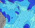 | 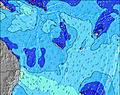 | 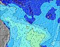 | 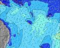 | 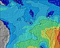 | 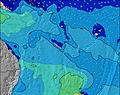 |  | ||||||||||||||
Wave Height (m) Direction Period (s) | NE 9 | E 6 | NE 9 | E 7 | E 7 | E 7 | E 7 | SW 12 | SW 12 | ESE 7 | E 7 | E 8 | NE 12 | NE 12 | NE 12 | NE 12 | NE 12 | ENE 8 | W 10 | E 8 | E 8 | E 8 |
Wave Graph | ||||||||||||||||||||||
13 | 0 | 12 | 0 | 0 | 0 | 0 | 6 | 6 | 0 | 0 | 0 | 6 | 6 | 6 | 6 | 6 | 0 | 2 | 0 | 0 | 0 | |
Wind (km/h) | ||||||||||||||||||||||
Wind State on-shore cross-onshore cross-shore cross-offshore off-shore glassy | cross-off | cross-off | cross-off | cross-off | cross-off | cross-off | cross-off | cross-off | cross-off | cross-off | cross-off | cross-off | cross-off | cross-off | cross-off | cross-off | cross-off | cross-off | cross-off | cross-off | cross-off | cross-off |
High Tide | 5:15PM1.11m | 4:31AM1.32m | 5:47PM1.15m | 5:06AM1.33m | 6:19PM1.17m | |||||||||||||||||
Low Tide | 10:48AM0.14m | 10:39PM0.56m | 11:21AM0.12m | 11:15PM0.55m | 11:53AM0.12m | |||||||||||||||||
6:13 | — | — | — | — | — | — | 6:13 | — | — | — | — | — | — | — | 6:13 | — | — | — | — | — | — | |
— | — | — | 5:30 | — | — | — | — | — | — | — | 5:30 | — | — | — | — | — | — | — | 5:31 | — | — | |
mm | — | — | — | — | — | 1 | 1 | — | — | — | — | — | — | — | — | — | — | — | — | — | — | — |
Temp °C | 22 | 23 | 23 | 23 | 23 | 21 | 23 | 22 | 23 | 23 | 23 | 23 | 23 | 22 | 23 | 23 | 23 | 24 | 23 | 23 | 23 | 23 |
Feels °C | 17 | 17 | 18 | 18 | 18 | 16 | 17 | 16 | 18 | 17 | 18 | 19 | 19 | 18 | 20 | 20 | 20 | 21 | 20 | 21 | 20 | 20 |
Swell 1 Height (m) Direction Period (s) | S 6 | S 6 | S 6 | S 13 | S 13 | S 12 | S 7 | S 12 | S 12 | S 7 | S 8 | S 8 | S 8 | S 8 | S 8 | S 8 | S 8 | S 8 | S 8 | S 8 | S 8 | S 8 |
9 | 10 | 6 | 29 | 29 | 26 | 27 | 11 | 11 | 17 | 18 | 18 | 19 | 19 | 19 | 11 | 11 | 12 | 11 | 5 | 5 | 5 | |
Swell 2 Height (m) Direction Period (s) | S 13 | S 12 | S 12 | S 6 | S 6 | S 6 | S 12 | SE 14 | SE 13 | S 11 | S 11 | SE 14 | SE 13 | SE 13 | SE 13 | SE 13 | SE 14 | SSE 14 | SE 14 | SSE 14 | SSE 14 | SSE 13 |
29 | 26 | 24 | 6 | 5 | 2 | 12 | 7 | 7 | 10 | 10 | 7 | 7 | 7 | 7 | 7 | 7 | 19 | 8 | 20 | 20 | 18 | |
Swell 3 Height (m) Direction Period (s) | NE 9 | ENE 9 | NE 9 | SE 14 | SE 14 | SE 14 | SE 14 | SW 12 | SW 12 | SE 14 | SE 14 | S 11 | NE 12 | NE 12 | NE 12 | NE 12 | NE 12 | E 15 | W 10 | E 19 | E 19 | E 19 |
13 | 8 | 12 | 8 | 8 | 8 | 8 | 6 | 6 | 7 | 7 | 3 | 6 | 6 | 6 | 6 | 6 | 4 | 2 | 7 | 7 | 7 | |
Wind waves Height (m) Direction Period (s) | ESE 6 | E 6 | E 6 | E 7 | E 7 | E 7 | E 7 | ESE 7 | ESE 7 | ESE 7 | E 7 | E 8 | E 8 | E 8 | E 8 | E 8 | E 8 | ENE 8 | ENE 8 | E 8 | E 8 | E 8 |
119 | 126 | 156 | 150 | 179 | 196 | 250 | 336 | 336 | 362 | 352 | 328 | 320 | 327 | 328 | 291 | 266 | 251 | 257 | 334 | 364 | 355 | |
Nearest Offshore or Glassy | ||||||||||||||||||||||
Distance (km) | 548 | 548 | 1827 | 994 | 548 | 548 | 548 | 548 | 548 | 548 | 548 | 548 | 548 | 548 | 548 | 548 | 548 | 558 | 558 | 556 | 548 | 548 |
Best forecast wave conditions in Efate | ||||||||||||||||||||||
Best forecast wave conditions in Vanuatu | ||||||||||||||||||||||
Header Global | ||||||||||||||||||||||
- Map Icons:
 Break
Break Live Wave Height (m)
 Live Wind Speed (km/h)
 Surf Rating (10 Max)
 Ocean Swells (m)
- Wind Speed (km/h)


FREE! Surf-Forecast.com widget for your website
The surf report / weather widget below is available to embed on third party websites free of charge and provides a summary of our Nagar surf forecast. Simply grab the html code snippet that we provide and paste it into your own site. You can choose your preferred language and metric/imperial units for the surf forecast feed to suit users of your site. Click here to get the code.
 Nearest