

Surf Forecasts:

Koh Phayam surf forecast from 1 Aug 2026:
- Most powerful swell: Tuesday 4 Aug, 7PM (local time) - 7.5ft (2.3m), 7s period, SW swell with 514 kJ wave energy.
Best Forecast Surf Conditions for Koh Phayam this week:
The most powerful waves expected at Koh Phayam in the next 16 days are 2.3m 7s and forecast to arrive on Tuesday (Aug 04) at 7PM. Winds are predicted to be onshore at the time the swell arrives. The largest open ocean swell (not directed at the beach) is 3.0m 9s period and expected on Thursday (Aug 06) at 10PM.
| Wave Type | Time (+07) & Date | Wave Height & Period |
|---|---|---|
| Next good surf (1 star+) | - | - |
| Best Surf | - | - |
| Most Powerful | 7PM (Tue 4th Aug) | 7.5ft (2.3m) 7s |
Table - best surf conditions forecast for Koh Phayam over the next 16 days.
The Lowdown
Alright folks, Rusty here. Let’s be straight with you – this stretch of coastline is having a rough August. The whole 16-day window looks like a write-off for any decent surf. We’re staring down the barrel of a long, flat spell with no real swell to get excited about. The first few days show nothing but tiny, weak 0.3ft bumps from the SW with a period of 13 seconds, but the wind is always on it, blowing straight onshore from the SW or SSW. The wave energy is a measly 7 – barely a ripple. From August 2nd right through to the 16th, the forecast is essentially blank. The swell energy flatlines at zero, and all we’ve got is a grim repeat of strong onshore breezes and risk of thunderstorms. It’s a total gap – no surf on offer for over two weeks.
Koh Phayam is the only break in the cards, but it’s a beginner-friendly spot that’s ‘fairly consistent’ in general – so this blank run is a bit of a kick in the teeth. The water is sitting at 86°F, which is about 2°F warmer than usual for this time of year – so it’s a warm bath, even if you’re just floating. With the wind hammering straight onshore and the swell non-existent, the setup here is more interesting for kite surfing than paddle surfing right now. Don’t hold your breath – but forecasts can change, and this area tends not to stay this poor for long.
Rusty.
Short Range ForecastModerate rain (total 12mm), heaviest on Sat morning. Warm (max 29°C on Sat afternoon, min 27°C on Sat night). Wind will be generally light. | Days 4-6 Weather SummaryHeavy rain (total 89mm), heaviest during Thu night. Warm (max 29°C on Tue morning, min 27°C on Tue night). Mainly fresh winds. | ||||||||||||||||||||
Saturday 1 | Sunday 2 | Monday 3 | Tuesday 4 | Wednesday 5 | Thursday 6 | Friday 7 | |||||||||||||||
AM | PM | Night | AM | PM | Night | AM | PM | Night | AM | PM | Night | AM | PM | Night | AM | PM | Night | AM | PM | Night | |
Swell Height Map | 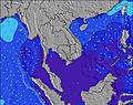 | 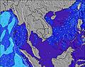 | 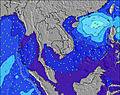 | 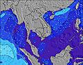 | 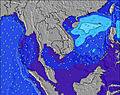 | 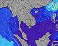 |  | ||||||||||||||
Wave Height (m) Direction Period (s) | SW 13 | SW 13 | WSW 16 | SW 15 | SW 3 | SW 16 | SW 15 | SW 15 | SW 18 | SW 18 | WSW 8 | SW 9 | WSW 8 | SW 6 | WSW 8 | WSW 9 | WSW 9 | WSW 9 | WSW 9 | WSW 9 | WSW 9 |
Wave Graph | |||||||||||||||||||||
7 | 6 | 0 | 0 | 2 | 0 | 0 | 0 | 13 | 12 | 0 | 0 | 0 | 0 | 0 | 0 | 0 | 0 | 0 | 0 | 0 | |
Wind (km/h) | |||||||||||||||||||||
Wind State on-shore cross-onshore cross-shore cross-offshore off-shore glassy | on | cross-on | cross-on | on | on | on | on | on | on | on | on | on | on | on | on | on | on | on | on | on | on |
High Tide | 12:07PM3.46m | 00:29AM3.23m | 12:39PM3.43m | 1:02AM3.26m | 1:12PM3.33m | 1:38AM3.22m | 1:48PM3.15m | 2:18AM3.10m | 2:29PM2.91m | 3:05AM2.93m | 3:21PM2.62m | 4:08AM2.73m | 4:35PM2.34m | ||||||||
Low Tide | 6:34PM0.20m | 6:40AM0.37m | 7:03PM0.21m | 7:13AM0.43m | 7:33PM0.27m | 7:49AM0.53m | 8:06PM0.39m | 8:30AM0.69m | 8:45PM0.56m | 9:21AM0.89m | 9:35PM0.78m | 10:33AM1.08m | 10:48PM0.99m | ||||||||
6:16 | — | — | 6:16 | — | — | 6:16 | — | — | 6:16 | — | — | 6:16 | — | — | 6:16 | — | — | 6:16 | — | — | |
— | 6:49 | — | — | 6:47 | — | — | 6:47 | — | — | 6:47 | — | — | 6:47 | — | — | 6:46 | — | — | 6:46 | — | |
mm | 3 | — | 1 | — | 1 | 1 | — | 2 | 4 | — | 1 | 5 | 9 | 8 | 17 | 10 | 11 | 28 | 11 | 9 | 22 |
Temp °C | 28 | 29 | 28 | 29 | 29 | 28 | 29 | 29 | 28 | 29 | 29 | 27 | 28 | 28 | 27 | 27 | 27 | 27 | 27 | 27 | 27 |
Feels °C | 31 | 32 | 32 | 32 | 32 | 31 | 31 | 31 | 31 | 30 | 30 | 27 | 28 | 27 | 27 | 26 | 26 | 26 | 26 | 26 | 25 |
Swell 1 Height (m) Direction Period (s) | W 8 | W 8 | W 8 | W 8 | W 8 | W 8 | SW 15 | SW 15 | W 8 | WSW 14 | — | WSW 16 | — | — | — | — | — | — | — | — | — |
65 | 65 | 45 | 32 | 30 | 41 | 55 | 54 | 57 | 20 | — | 26 | — | — | — | — | — | — | — | — | — | |
Swell 2 Height (m) Direction Period (s) | SW 16 | WSW 16 | WSW 16 | SW 15 | SW 15 | SW 16 | W 20 | W 9 | SW 14 | WSW 18 | — | — | — | — | — | — | — | — | — | — | — |
67 | 102 | 103 | 58 | 60 | 61 | 7 | 15 | 54 | 31 | — | — | — | — | — | — | — | — | — | — | — | |
Swell 3 Height (m) Direction Period (s) | SW 13 | SW 13 | W 12 | — | — | W 21 | W 20 | W 20 | SW 18 | SW 18 | — | — | — | — | — | — | — | — | — | — | — |
7 | 6 | 3 | — | — | 8 | 7 | 7 | 13 | 12 | — | — | — | — | — | — | — | — | — | — | — | |
Wind waves Height (m) Direction Period (s) | — | — | — | — | SW 3 | — | WSW 7 | WSW 7 | — | WSW 8 | WSW 8 | SW 9 | WSW 8 | SW 6 | WSW 8 | WSW 9 | WSW 9 | WSW 9 | WSW 9 | WSW 9 | WSW 9 |
— | — | — | — | 2 | — | 41 | 42 | — | 202 | 572 | 572 | 481 | 292 | 683 | 1093 | 907 | 1176 | 1069 | 1405 | 1144 | |
Nearest Offshore or Glassy | |||||||||||||||||||||
Distance (km) | 110 | 153 | 110 | 110 | 193 | 110 | 110 | 193 | 193 | 110 | 182 | 193 | 193 | 651 | 1273 | 1014 | 1014 | 820 | 1273 | 1211 | 832 |
Best forecast wave conditions in Andaman Sea | |||||||||||||||||||||
Best forecast wave conditions in Thailand | |||||||||||||||||||||
Header Global | |||||||||||||||||||||
- Map Icons:
 Break
Break Live Wave Height (m)
 Live Wind Speed (km/h)
 Surf Rating (10 Max)
 Ocean Swells (m)
- Wind Speed (km/h)
Latest Updates


FREE! Surf-Forecast.com widget for your website
The surf report / weather widget below is available to embed on third party websites free of charge and provides a summary of our Koh Phayam surf forecast. Simply grab the html code snippet that we provide and paste it into your own site. You can choose your preferred language and metric/imperial units for the surf forecast feed to suit users of your site. Click here to get the code.
Information about the Koh Phayam Surf forecast
The above surf forecast table for Koh Phayam provides essential information for determining whether the surfing conditions will be good over the next 16 days. A general guide to surfing at Koh Phayam can be found by selecting the local surf guide option on the grey menu. Our Koh Phayam surf forecast is unique since it includes wave energy (power) that defines the real feel of the surf rather than just the height or the period. If you surf the same spot (Koh Phayam) regularly then make a mental note of the wave energy from the surf forecast table each time you go. Very soon you may start to choose your surf days based on the wave energy alone combined with our forecast of favourable offshore wind conditions. Our star ratings will help here and of course you will also find the usual wave height and period predictions on our surf forecasts as well as a full break down of the swell components under our advanced users option (to reveal that, click the little Einstein character under the tide times).
Further information to help with frequently asked questions about our surf forecast for Koh Phayam may be found under the help tab on the top menu and also by moving your mouse over the question marks on the surf forecast table itself. Please always bear in mind that the forecast is for near-shore open water and local factors at each surf break influence the actual breaking wave height, such as the beach / reef profile, water depths offshore and shelter.
Koh Phayam is 34 km (21 miles) from Victoria Point. If you plan a holiday in Andaman Sea, look for hotels and other accommodation in Victoria Point. Victoria Point has rooms for a wide range of budgets as well as car hire and transport links.
 Nearest