

Surf Forecasts:

Galle surf forecast from 5 Jul 2026:
- Most powerful swell: Friday 10 Jul, 5AM (local time) - 7ft (2.1m), 12s period, WNW swell with 1,141 kJ wave energy.
Best Forecast Surf Conditions for Galle this week:
The most powerful waves expected at Galle in the next 16 days are 2.1m 12s and forecast to arrive on Friday (Jul 10) at 5AM. Winds are predicted to be cross-shore at the time the swell arrives.
| Wave Type | Time (+0530) & Date | Wave Height & Period |
|---|---|---|
| Next good surf (1 star+) | - | - |
| Best Surf | - | - |
| Most Powerful | 5AM (Fri 10th Jul) | 7ft (2.1m) 12s |
Table - best surf conditions forecast for Galle over the next 16 days.
Updates in hr min s Forecast update imminent
Alright folks, Rusty here. Let's have a look at what the next couple of weeks are serving up for us around Galle.
Right out of the gate, I gotta be honest with you – it's not looking like a classic run. The southwest monsoon is blowing steady, keeping a cross-shore breeze on the breaks pretty much non-stop. That wind, coming from the west at 12 to 16 mph, is going to put a chop on the surface just about every day. You’ll be battling a cross-chop more often than not.
We’ve got one break on the radar, the Galle reef/jetty spot. It’s exposed to the south-west and prefers a swell from the SW itself, which is a good start. But this break is inconsistent, it doesn't switch on all the time, so you have to pick your moments.
Now, for the first few days, through July 7th, it’s pretty grim. We are looking at small, weak swells with a combined energy barely cracking 600 to 700 (moderate). The swell is small, mostly around 2 ft to 5 ft, but a lot of it comes in from the west with a short period under 10 seconds. That's just weak, junky windswell. Give it a miss.
Things start to show a little more life from July 8th. The combined swell energy climbs into strong territory, hitting 1802 on Wednesday the 8th, with a 6 ft swell from the WNW. Still, the wind is cross-shore, so while there's more push, it won't be clean. The period is only around 10 seconds, so nothing special. The situation is frustrating: there’s decent sized swell but the wind ruins the 'wow' factor.
Even with bigger days like July 10th Friday afternoon – a 7 ft swell from the WNW with strong energy of 2656 – the wind stays cross-shore and on the chop. For the average punter, anything over 5 ft starts to get tricky, and this one is over 8 ft, so this is really an expert-only window, and even then, the bumpy conditions are a letdown.
The latter part of the week starting July 14th and beyond, we get a shift. The swell drops back, and the wind swings more from the WSW, becoming cross-onshore. That’s a worse angle, making things choppy. From July 15th onwards, the forecast is straight-up poor, with combined swell energy dropping back to moderate to weak as we head into the 17th and 18th of July. Honestly, from the second week onward, it’s a write-off for a decent surf.
The water temp is 84°F, which is normal for this time of year – no surprise there.
Truth is, there’s no true stand-out window here. The best bet, if you are desperate and an expert, is the afternoon of July 10th when the swell is biggest, but the wind is going to be a battle. For the rest of us, I’d say wait for the next change in the weather pattern. It’s not often a region stays this poor for this long, so forecasts can change, but for now, don't hold your breath.
Rusty.
Short Range ForecastLight rain (total 5mm), mostly falling on Tue morning. Warm (max 29°C on Mon afternoon, min 27°C on Sun morning). Wind will be generally light. | Days 4-6 Weather SummaryHeavy rain (total 29mm), heaviest during Thu afternoon. Warm (max 28°C on Wed morning, min 27°C on Wed morning). Wind will be generally light. | ||||||||||||||||||||
Sunday 5 | Monday 6 | Tuesday 7 | Wednesday 8 | Thursday 9 | Friday 10 | Saturday 11 | |||||||||||||||
AM | PM | Night | AM | PM | Night | AM | PM | Night | AM | PM | Night | AM | PM | Night | AM | PM | Night | AM | PM | Night | |
Swell Height Map | 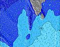 | 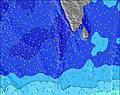 | 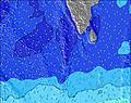 | 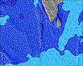 | 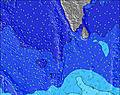 | 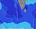 | 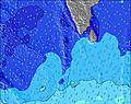 | ||||||||||||||
Wave Height (m) Direction Period (s) | W 8 | W 10 | W 10 | SSW 16 | W 10 | W 10 | SSW 16 | W 10 | W 10 | W 10 | W 10 | W 11 | W 11 | S 13 | SSW 15 | W 12 | WNW 12 | WNW 11 | W 11 | S 13 | W 10 |
Wave Graph | |||||||||||||||||||||
308 | 423 | 414 | 212 | 414 | 153 | 362 | 500 | 513 | 536 | 755 | 748 | 533 | 506 | 754 | 765 | 1141 | 1083 | 355 | 355 | 239 | |
Wind (km/h) | |||||||||||||||||||||
Wind State on-shore cross-onshore cross-shore cross-offshore off-shore glassy | cross | cross | cross | cross | cross | cross-on | cross | cross | cross | cross | cross | cross | cross | cross | cross | cross | cross | cross | cross | cross | cross |
High Tide | 5:27PM0.44m | 6:22AM0.42m | 6:00PM0.39m | 7:11AM0.41m | 6:36PM0.34m | 8:11AM0.40m | 7:25PM0.29m | 9:29AM0.40m | 8:59PM0.25m | 10:55AM0.42m | 11:02PM0.25m | 12:08PM0.45m | 00:29AM0.28m | ||||||||
Low Tide | 11:06AM0.10m | 11:32PM0.01m | 11:48AM0.13m | 00:04AM0.03m | 12:39PM0.16m | 00:44AM0.05m | 1:49PM0.20m | 1:37AM0.07m | 3:48PM0.21m | 2:51AM0.09m | 6:05PM0.18m | 4:27AM0.10m | 7:03PM0.13m | ||||||||
5:58 | — | — | 5:58 | — | — | 6:00 | — | — | 6:00 | — | — | 6:00 | — | — | 6:00 | — | — | 6:01 | — | — | |
— | 6:27 | — | — | 6:27 | — | — | 6:27 | — | — | 6:27 | — | — | 6:27 | — | — | 6:27 | — | — | 6:28 | — | |
mm | — | — | — | — | — | — | 1 | 2 | 2 | 2 | — | 5 | 4 | 6 | 5 | 2 | 1 | 4 | 4 | 2 | 2 |
Temp °C | 28 | 28 | 27 | 28 | 29 | 28 | 28 | 28 | 27 | 28 | 28 | 27 | 27 | 28 | 27 | 28 | 28 | 27 | 28 | 28 | 27 |
Feels °C | 29 | 28 | 28 | 28 | 28 | 29 | 29 | 29 | 29 | 29 | 28 | 30 | 28 | 29 | 29 | 29 | 29 | 29 | 29 | 29 | 29 |
Swell 1 Height (m) Direction Period (s) | S 10 | S 10 | S 10 | W 10 | S 10 | W 10 | W 10 | SSW 15 | SSW 16 | SSW 14 | W 10 | W 10 | W 11 | S 13 | SSW 15 | W 12 | W 12 | W 11 | W 11 | W 11 | W 10 |
100 | 96 | 100 | 183 | 96 | 153 | 153 | 331 | 513 | 536 | 500 | 467 | 533 | 506 | 754 | 765 | 752 | 632 | 338 | 279 | 239 | |
Swell 2 Height (m) Direction Period (s) | SSW 17 | SSW 16 | SSW 16 | S 10 | SSW 15 | S 10 | SSW 16 | S 9 | S 9 | S 9 | SSW 14 | SSW 14 | S 13 | W 11 | W 11 | SSW 14 | SSW 14 | SSW 14 | S 13 | S 13 | SSW 12 |
172 | 149 | 147 | 98 | 196 | 92 | 362 | 60 | 57 | 38 | 507 | 646 | 398 | 292 | 361 | 714 | 714 | 547 | 355 | 355 | 202 | |
Swell 3 Height (m) Direction Period (s) | SSW 13 | SSW 13 | SSW 13 | SSW 16 | S 19 | SSW 15 | S 9 | S 17 | SSE 9 | SSE 9 | S 9 | SSE 11 | SSW 16 | SSW 16 | SW 15 | SSE 9 | SW 18 | S 16 | S 16 | SSE 10 | S 15 |
68 | 67 | 70 | 212 | 27 | 121 | 85 | 220 | 65 | 65 | 40 | 41 | 427 | 350 | 33 | 50 | 49 | 48 | 132 | 9 | 106 | |
Wind waves Height (m) Direction Period (s) | W 8 | W 10 | W 10 | W 6 | W 10 | WSW 6 | WSW 7 | W 10 | W 10 | W 10 | W 10 | W 11 | — | W 7 | W 7 | — | WNW 12 | WNW 11 | W 7 | W 7 | W 6 |
308 | 423 | 414 | 108 | 414 | 127 | 131 | 500 | 500 | 490 | 755 | 748 | — | 107 | 107 | — | 1141 | 1083 | 124 | 145 | 76 | |
Nearest Offshore or Glassy | |||||||||||||||||||||
Distance (km) | 201 | 204 | 205 | 201 | 864 | 661 | 198 | 205 | 198 | 161 | 161 | 161 | 358 | 198 | 205 | 198 | 204 | 205 | 204 | 358 | 205 |
Best forecast wave conditions in West Sri Lanka | |||||||||||||||||||||
Best forecast wave conditions in Sri Lanka | |||||||||||||||||||||
Header Global | |||||||||||||||||||||
- Map Icons:
 Break
Break Live Wave Height (m)
 Live Wind Speed (km/h)
 Surf Rating (10 Max)
 Ocean Swells (m)
- Wind Speed (km/h)


FREE! Surf-Forecast.com widget for your website
The surf report / weather widget below is available to embed on third party websites free of charge and provides a summary of our Galle surf forecast. Simply grab the html code snippet that we provide and paste it into your own site. You can choose your preferred language and metric/imperial units for the surf forecast feed to suit users of your site. Click here to get the code.
Information about the Galle Surf forecast
The above surf forecast table for Galle provides essential information for determining whether the surfing conditions will be good over the next 16 days. A general guide to surfing at Galle can be found by selecting the local surf guide option on the grey menu. Our Galle surf forecast is unique since it includes wave energy (power) that defines the real feel of the surf rather than just the height or the period. If you surf the same spot (Galle) regularly then make a mental note of the wave energy from the surf forecast table each time you go. Very soon you may start to choose your surf days based on the wave energy alone combined with our forecast of favourable offshore wind conditions. Our star ratings will help here and of course you will also find the usual wave height and period predictions on our surf forecasts as well as a full break down of the swell components under our advanced users option (to reveal that, click the little Einstein character under the tide times).
Further information to help with frequently asked questions about our surf forecast for Galle may be found under the help tab on the top menu and also by moving your mouse over the question marks on the surf forecast table itself. Please always bear in mind that the forecast is for near-shore open water and local factors at each surf break influence the actual breaking wave height, such as the beach / reef profile, water depths offshore and shelter.
Galle is 3 km (2 miles) from Galle. If you plan a holiday in West Sri Lanka, look for hotels and other accommodation in Galle. Galle has rooms for a wide range of budgets as well as car hire and transport links.
 Nearest