

Surf Forecasts:

How big are the waves at Furana today (03 Aug):
- Morning surf: Morning surf (03 Aug, local time) - 2.5ft (0.7m), 16s period with SW swell.
- Afternoon surf: Afternoon surf (03 Aug, local time) - 3.5ft (1.0m), 17s period with SSW swell.
- Evening surf: Evening surf (03 Aug, local time) - 3.5ft (1.1m), 17s period with SSW swell.
The current surf forecast for Furana at 5PM is: 1.1m 17s primary swell from a South-southwest direction (forecast issued at 10:00am August 03). An open ocean swell of 1.4m 9s is not directed at the surf break, a second open ocean swell of 0.4m 3s is not directed at the surf break. The wind direction is predicted to be cross-offshore.
| Time (+05) & Date | Wave Height | Wave Period |
|---|---|---|
| Morning (03 Aug) | 2.5ft (0.7m) | 16s |
| Afternoon (03 Aug) | 3.5ft (1.0m) | 17s |
| Evening (03 Aug) | 3.5ft (1.1m) | 17s |
Table - waves today at Furana. (Swell directed towards the surf break)
Short Range ForecastHeavy rain (total 26mm), heaviest during Tue night. Warm (max 28°C on Mon afternoon, min 27°C on Mon morning). Wind will be generally light. | ||||||||||||||||||||||
Monday 3 | Tuesday 4 | Wednesday 5 | ||||||||||||||||||||
8 AM | 11 AM | 2 PM | 5 PM | 8 PM | 11 PM | 2 AM | 5 AM | 8 AM | 11 AM | 2 PM | 5 PM | 8 PM | 11 PM | 2 AM | 5 AM | 8 AM | 11 AM | 2 PM | 5 PM | 8 PM | 11 PM | |
Swell Height Map |  | 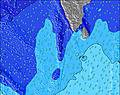 | 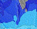 | 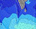 |  | 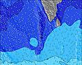 | 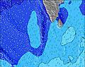 | 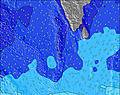 | ||||||||||||||
Wave Height (m) Direction Period (s) | SW 16 | SW 16 | SSW 16 | SSW 17 | SSW 17 | SSW 17 | SSW 16 | SSW 16 | SSW 16 | SSW 16 | SSW 15 | SSW 15 | SSW 15 | SSW 15 | SW 15 | S 20 | S 19 | SSW 19 | S 19 | SSW 18 | SSW 18 | SSW 18 |
Wave Graph | ||||||||||||||||||||||
295 | 203 | 475 | 657 | 673 | 657 | 604 | 582 | 679 | 662 | 629 | 612 | 596 | 505 | 323 | 485 | 480 | 627 | 738 | 861 | 832 | 790 | |
Wind (km/h) | ||||||||||||||||||||||
Wind State on-shore cross-onshore cross-shore cross-offshore off-shore glassy | cross-off | cross-off | cross-off | cross-off | off | off | off | cross-off | cross-off | cross-off | cross-off | cross-off | off | cross-off | cross-off | cross-off | cross-off | cross-off | cross-off | cross-off | cross-off | cross-off |
High Tide | 3:36PM0.88m | 4:20AM0.79m | 3:57PM0.82m | 5:02AM0.76m | 4:17PM0.75m | |||||||||||||||||
Low Tide | 9:27AM0.23m | 9:59PM0.12m | 10:00AM0.29m | 10:27PM0.11m | 10:35AM0.37m | 11:00PM0.12m | ||||||||||||||||
6:03 | — | — | — | — | — | — | 6:03 | — | — | — | — | — | — | — | 6:03 | — | — | — | — | — | — | |
— | — | — | 6:20 | — | — | — | — | — | — | — | 6:20 | — | — | — | — | — | — | — | 6:20 | — | — | |
mm | — | 2 | — | — | 1 | 1 | 1 | 1 | 1 | — | — | 1 | 3 | 3 | 4 | 2 | 1 | 1 | 1 | — | — | 1 |
Temp °C | 27 | 27 | 27 | 28 | 27 | 27 | 27 | 27 | 27 | 28 | 28 | 28 | 28 | 27 | 27 | 27 | 27 | 27 | 28 | 28 | 27 | 28 |
Feels °C | 29 | 28 | 27 | 29 | 28 | 29 | 29 | 28 | 28 | 29 | 29 | 29 | 29 | 28 | 28 | 27 | 27 | 27 | 27 | 28 | 27 | 29 |
Swell 1 Height (m) Direction Period (s) | WNW 9 | WNW 9 | WNW 9 | WNW 9 | WNW 9 | WNW 9 | WNW 9 | WNW 9 | WNW 9 | WNW 8 | SSW 15 | SSW 15 | SSW 15 | SSW 15 | SW 15 | SW 15 | SSW 15 | SSW 15 | S 19 | SSW 18 | SSW 18 | SSW 18 |
395 | 362 | 354 | 313 | 346 | 293 | 280 | 280 | 280 | 273 | 629 | 612 | 596 | 505 | 314 | 314 | 377 | 353 | 738 | 861 | 832 | 790 | |
Swell 2 Height (m) Direction Period (s) | SSE 9 | SSE 8 | SSW 16 | SSW 17 | SSW 17 | SSW 17 | SSW 16 | SSW 16 | SSW 16 | SSW 16 | SSE 8 | SSE 8 | SSE 8 | S 8 | S 17 | S 20 | S 19 | SSW 19 | SW 15 | S 10 | S 10 | S 10 |
141 | 113 | 475 | 657 | 673 | 657 | 604 | 582 | 679 | 662 | 75 | 67 | 65 | 29 | 204 | 485 | 480 | 627 | 226 | 98 | 125 | 158 | |
Swell 3 Height (m) Direction Period (s) | SW 16 | SW 16 | SSE 8 | SSE 8 | SSE 8 | SSE 8 | SSE 8 | SSE 8 | SSE 8 | SSE 8 | E 9 | E 9 | E 9 | S 21 | S 21 | S 8 | S 8 | S 9 | S 9 | WNW 10 | WNW 10 | WNW 10 |
295 | 203 | 137 | 134 | 108 | 99 | 108 | 96 | 76 | 75 | 2 | 2 | 2 | 220 | 323 | 28 | 28 | 39 | 39 | 42 | 55 | 41 | |
Wind waves Height (m) Direction Period (s) | — | — | — | WNW 3 | — | — | — | — | — | — | WNW 8 | WNW 8 | WNW 8 | WNW 8 | WNW 8 | WNW 8 | WNW 8 | WNW 8 | WNW 8 | WNW 8 | WNW 8 | WNW 8 |
— | — | — | 3 | — | — | — | — | — | — | 267 | 294 | 294 | 294 | 302 | 302 | 294 | 287 | 248 | 220 | 220 | 191 | |
Nearest Offshore or Glassy | ||||||||||||||||||||||
Distance (km) | 247 | 191 | 247 | 247 | 0 | 0 | 0 | 19 | 235 | 235 | 247 | 247 | 0 | 247 | 247 | 247 | 247 | 247 | 247 | 247 | 247 | 959 |
Best forecast wave conditions in North Male Atoll | ||||||||||||||||||||||
Best forecast wave conditions in Maldives | ||||||||||||||||||||||
Header Global | ||||||||||||||||||||||
- Map Icons:
 Break
Break Live Wave Height (m)
 Live Wind Speed (km/h)
 Surf Rating (10 Max)
 Ocean Swells (m)
- Wind Speed (km/h)
Latest Updates


FREE! Surf-Forecast.com widget for your website
The surf report / weather widget below is available to embed on third party websites free of charge and provides a summary of our Furana surf forecast. Simply grab the html code snippet that we provide and paste it into your own site. You can choose your preferred language and metric/imperial units for the surf forecast feed to suit users of your site. Click here to get the code.
 Nearest