

Surf Forecasts:

| Time (PST) & Date | Wave Height | Wave Period |
|---|---|---|
| Morning (23 Jul) | - | - |
| Afternoon (23 Jul) | - | - |
| Evening (23 Jul) | 1.5ft (0.4m) | 3s |
Table - waves today at Darigayos. (Swell directed towards the surf break)
Short Range ForecastHeavy rain (total 94mm), heaviest during Fri night. Warm (max 29°C on Thu morning, min 24°C on Fri afternoon). Winds increasing (calm on Thu morning, fresh winds from the SSW by Fri night). | ||||||||||||||||||||||||
Thursday 23 | Friday 24 | Saturday 25 | ||||||||||||||||||||||
2 AM | 5 AM | 8 AM | 11 AM | 2 PM | 5 PM | 8 PM | 11 PM | 2 AM | 5 AM | 8 AM | 11 AM | 2 PM | 5 PM | 8 PM | 11 PM | 2 AM | 5 AM | 8 AM | 11 AM | 2 PM | 5 PM | 8 PM | 11 PM | |
Swell Height Map | 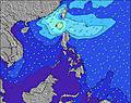 | 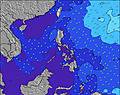 | 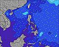 | 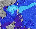 | 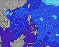 | 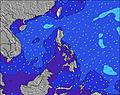 | 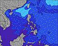 | 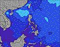 | 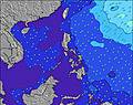 | |||||||||||||||
Wave Height (m) Direction Period (s) | WSW 7 | WSW 7 | WSW 7 | WSW 7 | WSW 7 | NW 3 | NW 3 | NNW 4 | NNW 5 | N 5 | NNW 4 | NNW 4 | NNW 4 | NNW 4 | NNW 4 | NNW 5 | NNW 6 | N 7 | NNW 7 | NW 7 | NW 7 | NW 8 | NW 8 | NW 8 |
Wave Graph | ||||||||||||||||||||||||
0 | 0 | 0 | 0 | 0 | 1 | 3 | 7 | 12 | 11 | 7 | 3 | 3 | 5 | 7 | 19 | 48 | 103 | 114 | 79 | 140 | 179 | 145 | 169 | |
Wind (km/h) | ||||||||||||||||||||||||
Wind State on-shore cross-onshore cross-shore cross-offshore off-shore glassy | cross-off | off | glassy | on | cross-on | cross | cross-off | glassy | glassy | cross-off | cross | on | cross | on | cross | cross-on | cross | cross | cross | cross | cross-on | cross | cross | cross-off |
High Tide | 4:08AM0.73m | 4:43AM0.80m | 5:22AM0.85m | |||||||||||||||||||||
Low Tide | 3:14PM0.23m | 3:20PM0.16m | 3:48PM0.11m | |||||||||||||||||||||
— | 5:35 | — | — | — | — | — | — | — | 5:35 | — | — | — | — | — | — | — | 5:35 | — | — | — | — | — | — | |
— | — | — | — | — | 6:34 | — | — | — | — | — | — | — | 6:34 | — | — | — | — | — | — | — | 6:32 | — | — | |
mm | 1 | 1 | — | — | 1 | 3 | 3 | 1 | 2 | 1 | 1 | 3 | 6 | 6 | 19 | 13 | 12 | 7 | 3 | 3 | 3 | 2 | 2 | 2 |
Temp °C | 27 | 26 | 28 | 29 | 29 | 29 | 28 | 28 | 27 | 26 | 28 | 28 | 25 | 24 | 24 | 25 | 26 | 26 | 27 | 28 | 28 | 28 | 27 | 27 |
Feels °C | 31 | 30 | 33 | 33 | 32 | 32 | 33 | 33 | 32 | 29 | 32 | 32 | 27 | 28 | 26 | 26 | 25 | 26 | 27 | 27 | 27 | 29 | 29 | 29 |
Swell 1 Height (m) Direction Period (s) | WSW 7 | WSW 7 | WSW 7 | WSW 7 | WSW 7 | WSW 7 | WSW 7 | NNW 4 | NNW 5 | N 5 | NNW 4 | SW 7 | SW 7 | SW 7 | NNW 4 | NNW 5 | NNW 6 | N 7 | NNW 7 | NW 7 | NW 7 | NW 8 | NW 8 | NW 8 |
26 | 27 | 27 | 28 | 27 | 18 | 18 | 7 | 12 | 11 | 7 | 12 | 12 | 12 | 7 | 19 | 48 | 103 | 114 | 79 | 140 | 179 | 145 | 169 | |
Swell 2 Height (m) Direction Period (s) | — | — | — | — | — | — | W 5 | WSW 7 | WSW 7 | SW 7 | SW 7 | NNW 4 | WSW 7 | — | SW 7 | SW 7 | WSW 7 | WSW 7 | SW 7 | N 8 | WSW 7 | SW 7 | WSW 6 | SW 7 |
— | — | — | — | — | — | 1 | 18 | 18 | 12 | 12 | 3 | 9 | — | 12 | 12 | 19 | 9 | 12 | 41 | 5 | 21 | 56 | 49 | |
Swell 3 Height (m) Direction Period (s) | — | — | — | — | — | — | — | W 5 | — | — | — | — | — | — | — | — | — | — | WSW 7 | — | — | — | — | — |
— | — | — | — | — | — | — | 1 | — | — | — | — | — | — | — | — | — | — | 5 | — | — | — | — | — | |
Wind waves Height (m) Direction Period (s) | — | — | — | — | — | NW 3 | NW 3 | — | — | — | — | — | NNW 4 | NNW 4 | — | — | S 2 | SSW 4 | SW 5 | SW 5 | SW 6 | SW 5 | — | — |
— | — | — | — | — | 1 | 3 | — | — | — | — | — | 3 | 5 | — | — | 1 | 25 | 49 | 63 | 77 | 35 | — | — | |
Nearest Offshore or Glassy | ||||||||||||||||||||||||
Distance (km) | 883 | 561 | 561 | 561 | 561 | 561 | 558 | 177 | 177 | 177 | 177 | 177 | 177 | 167 | 167 | 167 | 167 | 167 | 167 | 167 | 167 | 167 | 167 | 0 |
Best forecast wave conditions in West Luzon | ||||||||||||||||||||||||
Best forecast wave conditions in Philippines | ||||||||||||||||||||||||
Header Global | ||||||||||||||||||||||||
- Map Icons:
 Break
Break Live Wave Height (m)
 Live Wind Speed (km/h)
 Surf Rating (10 Max)
 Ocean Swells (m)
- Wind Speed (km/h)


FREE! Surf-Forecast.com widget for your website
The surf report / weather widget below is available to embed on third party websites free of charge and provides a summary of our Darigayos surf forecast. Simply grab the html code snippet that we provide and paste it into your own site. You can choose your preferred language and metric/imperial units for the surf forecast feed to suit users of your site. Click here to get the code.
 Nearest