

Surf Forecasts:

Boucan Rights surf forecast from 3 Aug 2026:
- Best quality surf: Saturday 8 Aug, 7AM (local time) - 4ft (1.2m), 18s period, SW swell with offshore winds.
- Most powerful swell: Saturday 8 Aug, 4PM (local time) - 4.5ft (1.4m), 16s period, SW swell with 952 kJ wave energy.
- Next surfable swell (1★+): Monday 3 Aug, 10AM (local time) - 4ft (1.2m), 14s period with SW swell.
Best Forecast Surf Conditions for Boucan Rights this week:
The surf forecast for Boucan Rights over the next 16 days: The first swell (rated 1 star or higher) is forecast to arrive on Monday (Aug 03) at 10AM. The primary swell is predicted to be 1.2m and 14s period with a secondary swell of 0.8m and 18s. The wind is predicted to be glassy as the swell arrives.
The most powerful waves expected at Boucan Rights in the next 16 days are 1.4m 16s and forecast to arrive on Saturday (Aug 08) at 4PM. Winds are predicted to be glassy at the time the swell arrives. The largest open ocean swell (not directed at the beach) is 0.8m 6s period and expected on Friday (Aug 07) at 7PM.
| Wave Type | Time (+04) & Date | Wave Height & Period |
|---|---|---|
| Next good surf (1 star+) | 10AM (Mon 3rd Aug) | 4ft (1.2m) 14s |
| Best Surf | 7AM (Sat 8th Aug) | 4ft (1.2m) 18s |
| Most Powerful | 4PM (Sat 8th Aug) | 4.5ft (1.4m) 16s |
Table - best surf conditions forecast for Boucan Rights over the next 16 days.
The Lowdown
Alright folks, Rusty here. Let’s break down what’s coming for Boucan Rights.
We’ve got a proper run of surf on the way. A consistent SW groundswell builds through the first week and really fires up into the second. The water is sitting at 77°F, which is a touch warmer than normal for this time of year, so that’s a nice little bonus.
We start on Monday the 3rd of August. The morning is glassy with a clean 4ft swell from the SW, period 14 seconds, and the combined energy is moderate at 965. It’s a reef break, so that long period will give you some nice, lined-up waves. This is a spot for the advanced crew, so don’t overestimate your ability. The afternoon holds up well with glassy conditions on a 4ft SW swell.
Tuesday the 4th drops a little, with 2ft SW swell in the morning, still glassy, but the energy is down to 289. It’s clean but small. Wednesday the 5th stays in that 2ft to 3ft range, with a very long 15-second period on the morning glass, which is a treat for the shape.
The real standout moment in the first week is Saturday the 8th of August. The morning is completely glassy, with a 4ft SW swell, a long 18-second period, and the energy jumps to 1008. This is excellent for experienced surfers. The afternoon picks up to 5ft, still glassy, with energy at 965. This is the pick of the first week.
We get a bit of a lull in quality on Sunday the 9th and Monday the 10th with some onshore wind and marginal conditions, but the solid stuff returns on Monday afternoon with a 5ft SW swell, 16-second period, and a clean cross-off breeze. The energy is strong at 1068.
Now, the second week is where it gets proper. Wednesday the 12th of August morning is a beauty: glassy, 5ft SW swell, 14-second period, and energy at 1063. Excellent for experienced surfers.
But the absolute top of the forecast is Thursday the 13th of August. The morning has a 7ft SSW swell, period 12 seconds, and energy is pumping at 1667. The afternoon is even better: a gentle offshore wind from the SSE at 9 mph, clean waves, 7ft from the SSW, and energy at 1792. This is big, powerful reef surf. If you’re an expert, this is your window. The 7ft is over 5ft, so it’s too big for beginners, and at 7ft, it’s expert territory.
The swell stays solid through the 14th, 15th, and 16th, with a massive spike on Monday the 17th of August. The morning is glassy with a 7ft SW swell, 16-second period, and energy at 2413. The afternoon hits 8ft SW, 16 seconds, 2594 energy. That’s strong to very strong energy. This is for the experienced crew only.
Finally, Tuesday the 18th of August closes out the run with similar numbers: 8ft to 7ft, glassy, and energy still over 2500. It’s a big, clean finish.
Crowds are listed as "often" here, so expect company on the better days, especially on the standouts.
Rusty.
Short Range ForecastLight rain (total 4mm), mostly falling on Wed morning. Warm (max 25°C on Mon morning, min 23°C on Mon night). Wind will be generally light. | Days 4-6 Weather SummaryLight rain (total 5mm), mostly falling on Thu night. Warm (max 24°C on Thu morning, min 22°C on Fri night). Wind will be generally light. | ||||||||||||||||||||
Monday 3 | Tuesday 4 | Wednesday 5 | Thursday 6 | Friday 7 | Saturday 8 | Sunday 9 | |||||||||||||||
AM | PM | Night | AM | PM | Night | AM | PM | Night | AM | PM | Night | AM | PM | Night | AM | PM | Night | AM | PM | Night | |
Swell Height Map | 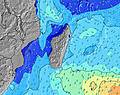 | 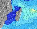 | 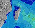 | 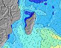 | 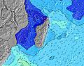 | 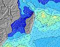 | 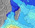 | ||||||||||||||
Wave Height (m) Direction Period (s) | SW 14 | SW 13 | SW 13 | SW 13 | S 13 | S 12 | SW 15 | SW 15 | SW 14 | SW 13 | SW 13 | SW 13 | SW 12 | SW 22 | SW 20 | SW 18 | SW 16 | SW 15 | SW 15 | SW 14 | SW 16 |
Wave Graph | |||||||||||||||||||||
557 | 444 | 246 | 161 | 168 | 141 | 229 | 318 | 284 | 261 | 253 | 199 | 178 | 235 | 753 | 915 | 952 | 597 | 685 | 466 | 644 | |
Wind (km/h) | |||||||||||||||||||||
Wind State on-shore cross-onshore cross-shore cross-offshore off-shore glassy | glassy | glassy | glassy | glassy | glassy | glassy | glassy | cross-off | glassy | cross-off | glassy | glassy | glassy | glassy | cross-off | glassy | glassy | off | cross-off | on | glassy |
High Tide | 3:39PM0.52m | 3:37AM0.48m | 4:14PM0.50m | 4:25AM0.43m | 4:58PM0.47m | 5:43AM0.37m | 6:08PM0.43m | 8:41AM0.35m | 8:10PM0.42m | 10:46AM0.40m | 9:54PM0.45m | 11:38AM0.46m | 10:58PM0.50m | ||||||||
Low Tide | 9:42PM0.19m | 9:50AM0.16m | 10:30PM0.20m | 10:28AM0.20m | 11:42PM0.22m | 11:27AM0.26m | 1:48AM0.21m | 1:53PM0.30m | 3:42AM0.16m | 4:00PM0.27m | 4:49AM0.09m | 5:05PM0.23m | |||||||||
6:48 | — | — | 6:48 | — | — | 6:48 | — | — | 6:48 | — | — | 6:47 | — | — | 6:46 | — | — | 6:46 | — | — | |
— | 6:00 | — | — | 6:00 | — | — | 6:00 | — | — | 6:01 | — | — | 6:01 | — | — | 6:01 | — | — | 6:02 | — | |
mm | — | — | — | — | — | — | 1 | 1 | 2 | — | — | 1 | — | — | 2 | — | 2 | — | — | 1 | 2 |
Temp °C | 25 | 24 | 24 | 25 | 24 | 23 | 25 | 24 | 23 | 24 | 24 | 23 | 23 | 23 | 23 | 23 | 23 | 22 | 23 | 23 | 23 |
Feels °C | 27 | 26 | 25 | 26 | 27 | 26 | 26 | 25 | 26 | 24 | 26 | 25 | 25 | 24 | 24 | 25 | 24 | 23 | 24 | 24 | 25 |
Swell 1 Height (m) Direction Period (s) | SW 14 | SW 13 | SW 13 | SW 13 | S 13 | S 12 | SW 15 | SW 15 | SW 14 | SW 13 | SW 13 | SW 13 | SW 12 | SW 12 | SW 20 | SW 18 | SW 16 | SW 15 | SW 15 | SW 14 | SW 16 |
557 | 444 | 246 | 161 | 168 | 141 | 229 | 318 | 284 | 261 | 253 | 199 | 178 | 152 | 753 | 915 | 952 | 597 | 685 | 466 | 644 | |
Swell 2 Height (m) Direction Period (s) | SSW 18 | S 16 | S 15 | S 13 | NE 6 | NE 10 | S 12 | NE 6 | NE 6 | NE 8 | NE 8 | NE 8 | NE 8 | NE 7 | SW 12 | SSW 12 | NE 11 | NE 11 | NE 8 | SW 18 | SW 13 |
408 | 257 | 155 | 128 | 21 | 67 | 100 | 23 | 23 | 33 | 40 | 21 | 33 | 37 | 149 | 93 | 77 | 42 | 16 | 255 | 168 | |
Swell 3 Height (m) Direction Period (s) | NE 6 | NE 6 | NE 10 | NE 10 | SW 12 | SW 16 | NE 10 | SSE 11 | SSE 11 | SSE 11 | SSE 10 | SSE 7 | SSW 15 | SW 22 | NE 6 | NE 11 | SSE 6 | SSE 6 | SSE 6 | NE 5 | SSE 10 |
20 | 27 | 69 | 69 | 73 | 127 | 63 | 42 | 39 | 38 | 18 | 11 | 72 | 235 | 33 | 77 | 13 | 12 | 8 | 15 | 31 | |
Wind waves Height (m) Direction Period (s) | — | — | — | — | — | — | — | — | — | — | — | — | — | SE 6 | — | — | — | — | — | SE 7 | — |
— | — | — | — | — | — | — | — | — | — | — | — | — | 85 | — | — | — | — | — | 64 | — | |
Nearest Offshore or Glassy | |||||||||||||||||||||
Distance (km) | 0 | 0 | 0 | 0 | 0 | 0 | 0 | 0 | 0 | 0 | 0 | 0 | 0 | 0 | 0 | 0 | 0 | 0 | 0 | 6 | 0 |
Best forecast wave conditions in Réunion Island | |||||||||||||||||||||
Best forecast wave conditions in Reunion | |||||||||||||||||||||
Header Global | |||||||||||||||||||||
- Map Icons:
 Break
Break Live Wave Height (m)
 Live Wind Speed (km/h)
 Surf Rating (10 Max)
 Ocean Swells (m)
- Wind Speed (km/h)
Latest Updates


FREE! Surf-Forecast.com widget for your website
The surf report / weather widget below is available to embed on third party websites free of charge and provides a summary of our Boucan Rights surf forecast. Simply grab the html code snippet that we provide and paste it into your own site. You can choose your preferred language and metric/imperial units for the surf forecast feed to suit users of your site. Click here to get the code.
Information about the Boucan Rights Surf forecast
The above surf forecast table for Boucan Rights provides essential information for determining whether the surfing conditions will be good over the next 16 days. A general guide to surfing at Boucan Rights can be found by selecting the local surf guide option on the grey menu. Our Boucan Rights surf forecast is unique since it includes wave energy (power) that defines the real feel of the surf rather than just the height or the period. If you surf the same spot (Boucan Rights) regularly then make a mental note of the wave energy from the surf forecast table each time you go. Very soon you may start to choose your surf days based on the wave energy alone combined with our forecast of favourable offshore wind conditions. Our star ratings will help here and of course you will also find the usual wave height and period predictions on our surf forecasts as well as a full break down of the swell components under our advanced users option (to reveal that, click the little Einstein character under the tide times).
Further information to help with frequently asked questions about our surf forecast for Boucan Rights may be found under the help tab on the top menu and also by moving your mouse over the question marks on the surf forecast table itself. Please always bear in mind that the forecast is for near-shore open water and local factors at each surf break influence the actual breaking wave height, such as the beach / reef profile, water depths offshore and shelter.
Boucan Rights is 4 km (2 miles) from Saint-Paul. If you plan a holiday in Réunion Island, look for hotels and other accommodation in Saint-Paul. Saint-Paul has rooms for a wide range of budgets as well as car hire and transport links.
 Nearest