

Surf Forecasts:

Big Wave Bay surf forecast from 2 Aug 2026:
- Most powerful swell: Tuesday 4 Aug, 5PM (local time) - 1.5ft (0.4m), 15s period, SE swell with 60 kJ wave energy.
Best Forecast Surf Conditions for Big Wave Bay this week:
The most powerful waves expected at Big Wave Bay in the next 16 days are 0.4m 15s and forecast to arrive on Tuesday (Aug 04) at 5PM. Winds are predicted to be glassy at the time the swell arrives. The largest open ocean swell (not directed at the beach) is 2.0m 9s period and expected on Sunday (Aug 09) at 11PM.
| Wave Type | Time (HKT) & Date | Wave Height & Period |
|---|---|---|
| Next good surf (1 star+) | - | - |
| Best Surf | - | - |
| Most Powerful | 5PM (Tue 4th Aug) | 1.5ft (0.4m) 15s |
Table - best surf conditions forecast for Big Wave Bay over the next 16 days.
The Lowdown
Alright, let’s get this straight right off the bat: there’s nothing doing here. I’ve looked at the whole 16-day window, and honestly, we’ve got a flat spell that’s just heartbreaking. The first sign of any real surf? Forget it. For the first week and a half, from the start of the period all the way through to the 17th of August, there’s barely a ripple. The combined wave energy is sitting at zero or teeny single-digit numbers (like 0 to 17) for the vast majority of that time. It’s a total write-off.
Big Wave Bay is a sheltered beginner spot, and it’s just not getting any love from the swell window. The optimum direction is NE, but everything coming in is from the SE or E, with tiny swell heights of 0.3 ft to 0.7 ft and periods that are all over the place – some short, some long, but none of it matters when there’s no power. The water temp is 84°, which is bang on normal for this time of year. Nothing unusual there.
The only faint glimmer is on the afternoon of the 8th of August, when we see a tiny 3 ft swell from the SW with a period of just 4 seconds. That’s a weak, short-period windswell, and the combined energy is only 25. The wind is cross-off from the WSW, so it’ll be clean looking, but there’s no power to surf. That’s not a standout, it’s a tease.
After that, it’s more of the same – flat, with the occasional 0.3 ft bump. We don’t see any real improvement until the 17th of August, and even then, it’s just a 0.3 ft wave from the east with a combined energy of 3. That’s not surfable.
For a spot that’s fairly consistent, this is a rough run. But it happens – sometimes the ocean just shuts down. The forecasts can change, so don’t lose hope, but for now, leave the boards in the car and go for a paddle or a swim. There’s nothing here for a surfer.
Rusty
Short Range ForecastHeavy rain (total 110mm), heaviest during Mon morning. Warm (max 28°C on Wed afternoon, min 24°C on Mon morning). Wind will be generally light. | Days 4-6 Weather SummaryLight rain (total 5mm), mostly falling on Sat night. Warm (max 32°C on Sat afternoon, min 27°C on Thu morning). Wind will be generally light. | ||||||||||||||||||||
Monday 3 | Tuesday 4 | Wednesday 5 | Thursday 6 | Friday 7 | Saturday 8 | Sunday 9 | |||||||||||||||
AM | PM | Night | AM | PM | Night | AM | PM | Night | AM | PM | Night | AM | PM | Night | AM | PM | Night | AM | PM | Night | |
Swell Height Map | 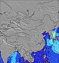 | 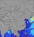 | 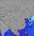 | 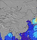 | 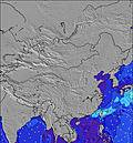 | 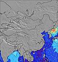 | 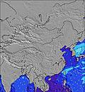 | ||||||||||||||
Wave Height (m) Direction Period (s) | SE 19 | SE 17 | ESE 16 | ESE 16 | SE 15 | SE 15 | ESE 14 | ESE 18 | ESE 17 | SE 16 | E 6 | SE 19 | SE 18 | SE 22 | SW 4 | SSW 9 | SW 4 | E 15 | E 15 | E 16 | SE 16 |
Wave Graph | |||||||||||||||||||||
14 | 12 | 25 | 24 | 60 | 55 | 18 | 30 | 29 | 9 | 2 | 14 | 13 | 18 | 14 | 0 | 25 | 4 | 5 | 5 | 10 | |
Wind (km/h) | |||||||||||||||||||||
Wind State on-shore cross-onshore cross-shore cross-offshore off-shore glassy | cross-on | on | on | on | glassy | glassy | glassy | glassy | cross-off | glassy | cross | cross-off | cross-off | cross | cross-off | cross-off | cross-off | cross-off | off | cross-off | cross-off |
High Tide | 10:42AM1.51m | 11:41PM1.20m | 11:23AM1.33m | 00:14AM1.35m | 12:08PM1.13m | 00:54AM1.48m | 1:00PM0.91m | 1:42AM1.59m | 2:11PM0.69m | 2:40AM1.68m | 3:52AM1.76m | 9:23PM0.83m | |||||||||
Low Tide | 6:14PM0.34m | 6:22AM0.60m | 6:43PM0.44m | 7:29AM0.56m | 7:12PM0.55m | 8:42AM0.50m | 7:40PM0.65m | 10:02AM0.41m | 3:50PM0.68m | 8:03PM0.74m | 11:23AM0.29m | 12:38PM0.16m | 10:09PM0.83m | ||||||||
5:54 | — | — | 5:54 | — | — | 5:56 | — | — | 5:56 | — | — | 5:56 | — | — | 5:56 | — | — | 5:56 | — | — | |
— | 7:01 | — | — | 7:01 | — | — | 7:00 | — | — | 7:00 | — | — | 7:00 | — | — | 6:59 | — | — | 6:59 | — | |
mm | 70 | 16 | 1 | 9 | 9 | 5 | — | — | — | — | — | — | — | — | — | — | — | 5 | — | — | 2 |
Temp °C | 25 | 25 | 26 | 27 | 25 | 25 | 26 | 28 | 27 | 28 | 29 | 28 | 30 | 30 | 29 | 31 | 32 | 30 | 32 | 33 | 30 |
Feels °C | 27 | 27 | 29 | 31 | 30 | 29 | 31 | 32 | 30 | 31 | 31 | 30 | 33 | 31 | 32 | 34 | 35 | 34 | 36 | 35 | 33 |
Swell 1 Height (m) Direction Period (s) | SE 19 | SE 17 | S 7 | S 6 | S 6 | SSW 6 | ESE 6 | ESE 6 | SSW 7 | S 7 | S 7 | S 8 | S 7 | S 7 | S 7 | SSW 7 | S 9 | E 15 | SSW 9 | E 16 | SSW 9 |
14 | 12 | 33 | 22 | 20 | 13 | 14 | 8 | 15 | 26 | 37 | 61 | 54 | 36 | 39 | 76 | 160 | 4 | 265 | 5 | 249 | |
Swell 2 Height (m) Direction Period (s) | E 9 | E 9 | ESE 16 | ESE 16 | SE 15 | ESE 6 | SSW 6 | SSW 6 | ESE 6 | ESE 6 | E 6 | SE 19 | SE 18 | SE 22 | E 21 | S 10 | — | — | E 15 | — | SE 16 |
2 | 2 | 25 | 24 | 60 | 14 | 8 | 8 | 7 | 3 | 2 | 14 | 13 | 18 | 9 | 45 | — | — | 5 | — | 10 | |
Swell 3 Height (m) Direction Period (s) | E 6 | E 9 | E 9 | E 7 | ESE 7 | SE 15 | ESE 14 | ESE 18 | ESE 17 | SE 16 | E 10 | E 5 | — | — | — | — | — | — | — | — | — |
1 | 2 | 2 | 4 | 9 | 55 | 18 | 30 | 29 | 9 | 2 | 1 | — | — | — | — | — | — | — | — | — | |
Wind waves Height (m) Direction Period (s) | S 7 | S 7 | — | — | — | — | — | — | — | — | — | SSW 3 | — | SSW 2 | SW 4 | SSW 9 | SW 4 | SSW 9 | — | SSW 9 | SW 8 |
72 | 57 | — | — | — | — | — | — | — | — | — | 1 | — | 1 | 14 | 334 | 25 | 297 | — | 469 | 567 | |
Nearest Offshore or Glassy | |||||||||||||||||||||
Distance (km) | 619 | 670 | 619 | 672 | 3 | 3 | 6 | 670 | 581 | 581 | 581 | 581 | 272 | 581 | 581 | 40 | 683 | 40 | 6 | 40 | 40 |
Best forecast wave conditions in Hong Kong | |||||||||||||||||||||
Best forecast wave conditions in China | |||||||||||||||||||||
Header Global | |||||||||||||||||||||
- Map Icons:
 Break
Break Live Wave Height (m)
 Live Wind Speed (km/h)
 Surf Rating (10 Max)
 Ocean Swells (m)
- Wind Speed (km/h)
Latest Updates


FREE! Surf-Forecast.com widget for your website
The surf report / weather widget below is available to embed on third party websites free of charge and provides a summary of our Big Wave Bay surf forecast. Simply grab the html code snippet that we provide and paste it into your own site. You can choose your preferred language and metric/imperial units for the surf forecast feed to suit users of your site. Click here to get the code.
Information about the Big Wave Bay Surf forecast
The above surf forecast table for Big Wave Bay provides essential information for determining whether the surfing conditions will be good over the next 16 days. A general guide to surfing at Big Wave Bay can be found by selecting the local surf guide option on the grey menu. Our Big Wave Bay surf forecast is unique since it includes wave energy (power) that defines the real feel of the surf rather than just the height or the period. If you surf the same spot (Big Wave Bay) regularly then make a mental note of the wave energy from the surf forecast table each time you go. Very soon you may start to choose your surf days based on the wave energy alone combined with our forecast of favourable offshore wind conditions. Our star ratings will help here and of course you will also find the usual wave height and period predictions on our surf forecasts as well as a full break down of the swell components under our advanced users option (to reveal that, click the little Einstein character under the tide times).
Further information to help with frequently asked questions about our surf forecast for Big Wave Bay may be found under the help tab on the top menu and also by moving your mouse over the question marks on the surf forecast table itself. Please always bear in mind that the forecast is for near-shore open water and local factors at each surf break influence the actual breaking wave height, such as the beach / reef profile, water depths offshore and shelter.
Are you planning a holiday in Hong Kong? If you are looking for accommodation near Big Wave Bay, camping, hotels and holiday cottages in Hong Kong, consider staying in Hong Kong which is 9 km (6 miles) away. Other places in and around Hong Kong where you can find information about places to rent, and car hire include Aberdeen which is 10 km (6 miles) away, Kowloon, Shenzhen and Yantian.
 Nearest