

Surf Forecasts:

Anse de Rémire (L'apcat) surf forecast from 3 Aug 2026:
- Most powerful swell: Thursday 6 Aug, 3AM (local time) - 2ft (0.6m), 8s period, ENE swell with 48 kJ wave energy.
Best Forecast Surf Conditions for Anse de Rémire (L'apcat) this week:
The most powerful waves expected at Anse de Rémire (L'apcat) in the next 16 days are 0.6m 8s and forecast to arrive on Thursday (Aug 06) at 3AM. Winds are predicted to be cross-onshore at the time the swell arrives.
| Wave Type | Time (-03) & Date | Wave Height & Period |
|---|---|---|
| Next good surf (1 star+) | - | - |
| Best Surf | - | - |
| Most Powerful | 3AM (Thu 6th Aug) | 2ft (0.6m) 8s |
Table - best surf conditions forecast for Anse de Rémire (L'apcat) over the next 16 days.
The Lowdown
Right then, let’s have a look at what’s on offer for the next couple of weeks.
To be honest, mate, it’s a tough stretch. This whole 16-day window is looking like a write-off for decent waves. The surf is just too weak and chopped up to get excited about. We’ve got a long gap of nothing really worth paddling out for, from now all the way through to mid-August. The first hint of any real energy doesn’t show up until Wednesday the 12th of August, and even then it’s not great.
The only spot we’ve got to look at is Anse de Rémière (L'apcat). It’s an exposed spot, so it catches whatever is out there, but the wind is just relentless. It’s coming from the east and southeast, blowing cross or cross-onshore, which is chopping everything up. The swell is tiny, mostly around 1 ft to 2 ft from the northeast, with periods under 8 seconds – that’s just windswell, no push or shape to it. The combined energy is practically nothing, often in the 20s and 30s (weak energy), so there’s no power. The water temp is sitting at 83°, which is about average for this time of year, so at least you won’t be cold while you’re sitting there staring at flat water.
It’s rated as an intermediate break, but with these conditions, it’s honestly not worth the paddle for anyone. The crowds are listed as ‘always’, so even if the surf was half-decent, you’d have to fight for a wave. Just keep the board in the car for now.
So, the bottom line: there’s nothing to recommend. The whole forecast is a dud. It’s just one of those blank runs for the area. Forecasts can change, but for now, it’s a no-go.
Rusty
Short Range ForecastModerate rain (total 10mm), heaviest on Mon night. Warm (max 28°C on Mon afternoon, min 26°C on Mon morning). Wind will be generally light. | Days 4-6 Weather SummaryLight rain (total 5mm), mostly falling on Thu morning. Warm (max 28°C on Thu afternoon, min 25°C on Fri night). Wind will be generally light. | ||||||||||||||||||||
Monday 3 | Tuesday 4 | Wednesday 5 | Thursday 6 | Friday 7 | Saturday 8 | Sunday 9 | |||||||||||||||
AM | PM | Night | AM | PM | Night | AM | PM | Night | AM | PM | Night | AM | PM | Night | AM | PM | Night | AM | PM | Night | |
Swell Height Map | 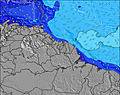 | 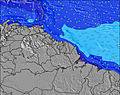 | 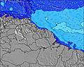 | 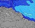 | 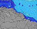 | 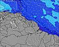 | 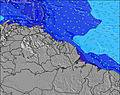 | ||||||||||||||
Wave Height (m) Direction Period (s) | NE 7 | NE 7 | NE 7 | NE 7 | E 4 | NE 10 | NE 9 | NE 9 | NE 9 | NE 8 | NE 6 | NE 6 | NNE 7 | NNE 7 | NE 7 | NE 7 | NE 6 | NNE 7 | NE 6 | E 4 | E 8 |
Wave Graph | |||||||||||||||||||||
26 | 25 | 17 | 12 | 18 | 15 | 13 | 28 | 27 | 24 | 11 | 10 | 31 | 31 | 22 | 23 | 20 | 18 | 21 | 19 | 43 | |
Wind (km/h) | |||||||||||||||||||||
Wind State on-shore cross-onshore cross-shore cross-offshore off-shore glassy | cross | cross-on | cross-on | cross | cross-on | cross-on | cross-on | cross-on | cross-on | cross-on | cross-on | cross-on | cross-on | cross-on | cross-on | cross-on | cross-on | cross-on | cross-on | cross-on | cross-on |
High Tide | 8:08PM2.25m | 8:28AM2.13m | 8:51PM2.19m | 9:21AM2.00m | 9:45PM2.13m | 10:29AM1.87m | 10:52PM2.09m | 11:52AM1.82m | 00:10AM2.12m | 1:14PM1.87m | 1:26AM2.22m | 2:24PM2.00m | 2:31AM2.38m | ||||||||
Low Tide | 1:49PM0.39m | 2:13AM0.46m | 2:28PM0.51m | 3:01AM0.53m | 3:14PM0.64m | 4:02AM0.60m | 4:13PM0.77m | 5:18AM0.64m | 5:30PM0.85m | 6:48AM0.58m | 6:59PM0.83m | 8:07AM0.44m | 8:15PM0.70m | ||||||||
6:24 | — | — | 6:24 | — | — | 6:24 | — | — | 6:24 | — | — | 6:24 | — | — | 6:24 | — | — | 6:24 | — | — | |
— | 6:44 | — | — | 6:44 | — | — | 6:44 | — | — | 6:44 | — | — | 6:44 | — | — | 6:43 | — | — | 6:43 | — | |
mm | 1 | 2 | 4 | — | 1 | — | — | — | 2 | 4 | 1 | — | — | — | — | — | — | — | — | — | — |
Temp °C | 27 | 28 | 27 | 28 | 28 | 27 | 28 | 28 | 27 | 27 | 28 | 27 | 28 | 28 | 27 | 28 | 28 | 27 | 28 | 28 | 27 |
Feels °C | 29 | 29 | 29 | 29 | 29 | 28 | 28 | 28 | 29 | 28 | 30 | 30 | 29 | 29 | 28 | 30 | 30 | 29 | 30 | 29 | 29 |
Swell 1 Height (m) Direction Period (s) | NE 7 | NE 7 | NE 7 | NE 7 | NE 7 | NE 7 | NE 9 | NE 9 | NE 9 | NE 8 | NE 6 | NE 6 | NNE 7 | NNE 7 | NE 7 | NE 7 | NE 6 | NNE 7 | NE 6 | NNE 6 | NNE 6 |
26 | 25 | 17 | 12 | 7 | 7 | 13 | 28 | 27 | 24 | 8 | 9 | 31 | 31 | 22 | 23 | 20 | 18 | 21 | 16 | 15 | |
Swell 2 Height (m) Direction Period (s) | E 7 | — | E 9 | E 9 | NE 11 | NE 10 | NE 6 | N 10 | E 8 | E 8 | NE 8 | NE 8 | E 8 | N 10 | N 10 | E 8 | NE 10 | NE 10 | E 8 | NE 9 | NE 9 |
1 | — | 2 | 6 | 4 | 15 | 6 | 2 | 5 | 10 | 11 | 10 | 5 | 2 | 2 | 5 | 4 | 4 | 5 | 3 | 3 | |
Swell 3 Height (m) Direction Period (s) | — | — | E 9 | NE 11 | N 11 | — | — | — | — | NNE 7 | E 8 | E 8 | N 11 | NE 10 | NE 10 | N 10 | NNE 10 | — | NE 9 | — | N 12 |
— | — | 6 | 5 | 2 | — | — | — | — | 10 | 10 | 5 | 2 | 4 | 4 | 2 | 9 | — | 3 | — | 3 | |
Wind waves Height (m) Direction Period (s) | E 4 | E 3 | E 3 | E 4 | E 4 | E 4 | E 4 | E 4 | E 4 | — | — | E 3 | ESE 3 | E 8 | E 4 | E 4 | E 4 | E 4 | ESE 4 | E 4 | E 8 |
2 | 4 | 4 | 7 | 18 | 13 | 12 | 12 | 9 | — | — | 1 | 2 | 31 | 11 | 13 | 12 | 12 | 6 | 19 | 43 | |
Nearest Offshore or Glassy | |||||||||||||||||||||
Distance (km) | 1659 | 1209 | 1191 | 1175 | 1175 | 1191 | 1742 | 1716 | 1659 | 1742 | 1742 | 1659 | 1742 | 1314 | 1314 | 2020 | 1175 | 1239 | 1239 | 1191 | 1635 |
Best forecast wave conditions in French Guiana | |||||||||||||||||||||
Best forecast wave conditions in French Guiana | |||||||||||||||||||||
Header Global | |||||||||||||||||||||
- Map Icons:
 Break
Break Live Wave Height (m)
 Live Wind Speed (km/h)
 Surf Rating (10 Max)
 Ocean Swells (m)
- Wind Speed (km/h)
Latest Updates


FREE! Surf-Forecast.com widget for your website
The surf report / weather widget below is available to embed on third party websites free of charge and provides a summary of our Anse de Rémire (L'apcat) surf forecast. Simply grab the html code snippet that we provide and paste it into your own site. You can choose your preferred language and metric/imperial units for the surf forecast feed to suit users of your site. Click here to get the code.
Information about the Anse de Rémire (L'apcat) Surf forecast
The above surf forecast table for Anse de Rémire (L'apcat) provides essential information for determining whether the surfing conditions will be good over the next 16 days. A general guide to surfing at Anse de Rémire (L'apcat) can be found by selecting the local surf guide option on the grey menu. Our Anse de Rémire (L'apcat) surf forecast is unique since it includes wave energy (power) that defines the real feel of the surf rather than just the height or the period. If you surf the same spot (Anse de Rémire (L'apcat)) regularly then make a mental note of the wave energy from the surf forecast table each time you go. Very soon you may start to choose your surf days based on the wave energy alone combined with our forecast of favourable offshore wind conditions. Our star ratings will help here and of course you will also find the usual wave height and period predictions on our surf forecasts as well as a full break down of the swell components under our advanced users option (to reveal that, click the little Einstein character under the tide times).
Further information to help with frequently asked questions about our surf forecast for Anse de Rémire (L'apcat) may be found under the help tab on the top menu and also by moving your mouse over the question marks on the surf forecast table itself. Please always bear in mind that the forecast is for near-shore open water and local factors at each surf break influence the actual breaking wave height, such as the beach / reef profile, water depths offshore and shelter.
Anse de Rémire (L'apcat) is 3 km (2 miles) from Remire-Montjoly. If you plan a holiday in French Guiana, look for hotels and other accommodation in Remire-Montjoly. Remire-Montjoly has rooms for a wide range of budgets as well as car hire and transport links.
 Nearest