

Surf Forecasts:

How big are the waves at Thicklip today (03 Aug):
- Morning surf: Morning surf (03 Aug, local time) - 2ft (0.6m), 12s period with SW swell.
- Afternoon surf: Afternoon surf (03 Aug, local time) - 1.5ft (0.4m), 14s period with SW swell.
- Evening surf: Evening surf (03 Aug, local time) - 1.5ft (0.5m), 14s period with SW swell.
The current surf forecast for Thicklip at 12PM is: 0.6m 11s primary swell from a West-southwest direction and 0.4m 5s secondary swell from a Southwest direction (forecast issued at 07:00am August 03). The wind direction is predicted to be cross-onshore.
| Time (CAT) & Date | Wave Height | Wave Period |
|---|---|---|
| Morning (03 Aug) | 2ft (0.6m) | 12s |
| Afternoon (03 Aug) | 1.5ft (0.4m) | 14s |
| Evening (03 Aug) | 1.5ft (0.5m) | 14s |
Table - waves today at Thicklip. (Swell directed towards the surf break)
Short Range ForecastMostly dry. Warm (max 23°C on Mon afternoon, min 13°C on Mon night). Wind will be generally light. | |||||||||||||||||||||||
Monday 3 | Tuesday 4 | Wednesday 5 | |||||||||||||||||||||
5 AM | 8 AM | 11 AM | 2 PM | 5 PM | 8 PM | 11 PM | 2 AM | 5 AM | 8 AM | 11 AM | 2 PM | 5 PM | 8 PM | 11 PM | 2 AM | 5 AM | 8 AM | 11 AM | 2 PM | 5 PM | 8 PM | 11 PM | |
Swell Height Map | 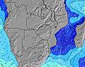 | 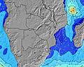 | 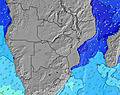 | 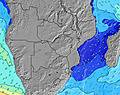 | 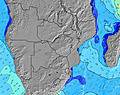 | 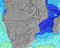 | 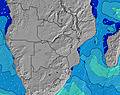 | 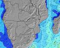 | 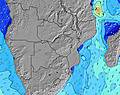 | ||||||||||||||
Wave Height (m) Direction Period (s) | SW 12 | SW 12 | SW 11 | SW 11 | SW 14 | SW 14 | SW 14 | SW 13 | SW 13 | SW 13 | SW 13 | SW 12 | WSW 12 | SW 12 | WSW 14 | WSW 14 | WSW 12 | WSW 12 | WSW 11 | WSW 11 | WSW 11 | WSW 11 | WSW 10 |
Wave Graph | |||||||||||||||||||||||
108 | 112 | 104 | 58 | 103 | 103 | 91 | 180 | 178 | 245 | 238 | 216 | 251 | 205 | 160 | 143 | 294 | 280 | 256 | 251 | 135 | 164 | 123 | |
Wind (km/h) | |||||||||||||||||||||||
Wind State on-shore cross-onshore cross-shore cross-offshore off-shore glassy | glassy | glassy | on | cross | cross | cross-on | cross-on | cross | cross | cross-on | cross-on | on | cross-on | cross | cross | glassy | glassy | cross | cross-on | cross-on | cross-on | cross | cross-on |
High Tide | 6:29PM1.39m | 7:03AM1.27m | 7:12PM1.32m | 7:54AM1.20m | 8:05PM1.24m | ||||||||||||||||||
Low Tide | 12:07PM0.31m | 00:39AM0.22m | 12:49PM0.37m | 1:24AM0.28m | 1:41PM0.44m | ||||||||||||||||||
7:33 | — | — | — | — | — | — | — | 7:33 | — | — | — | — | — | — | — | 7:33 | — | — | — | — | — | — | |
— | — | — | — | 6:40 | — | — | — | — | — | — | — | 6:42 | — | — | — | — | — | — | — | 6:42 | — | — | |
mm | — | — | — | — | — | — | — | — | — | — | — | — | — | — | — | — | — | — | — | — | — | — | — |
Temp °C | 14 | 16 | 18 | 20 | 23 | 18 | 13 | 13 | 13 | 13 | 14 | 15 | 15 | 14 | 14 | 14 | 14 | 13 | 15 | 15 | 15 | 15 | 14 |
Feels °C | 13 | 15 | 15 | 18 | 20 | 13 | 12 | 10 | 10 | 12 | 13 | 13 | 13 | 13 | 13 | 14 | 13 | 12 | 13 | 12 | 11 | 12 | 11 |
Swell 1 Height (m) Direction Period (s) | SW 12 | SW 12 | SW 11 | SW 11 | SW 11 | SW 14 | SW 14 | SW 13 | SW 13 | SW 13 | SW 13 | SW 12 | WSW 12 | SW 12 | WSW 14 | SW 11 | WSW 12 | WSW 12 | WSW 11 | WSW 11 | WSW 11 | WSW 11 | WSW 10 |
108 | 112 | 104 | 58 | 58 | 103 | 91 | 180 | 178 | 245 | 238 | 216 | 251 | 205 | 160 | 128 | 294 | 280 | 256 | 251 | 135 | 164 | 123 | |
Swell 2 Height (m) Direction Period (s) | SW 5 | SW 5 | SW 5 | SW 13 | SW 14 | SW 11 | SW 4 | SW 5 | SW 5 | SW 5 | WSW 5 | WSW 16 | WSW 16 | WSW 15 | SW 11 | WSW 14 | W 4 | — | SW 16 | SW 20 | SW 10 | SW 11 | SW 18 |
9 | 6 | 6 | 44 | 103 | 58 | 10 | 16 | 13 | 13 | 10 | 25 | 49 | 74 | 58 | 143 | 1 | — | 10 | 15 | 67 | 55 | 109 | |
Swell 3 Height (m) Direction Period (s) | W 18 | W 18 | WSW 16 | WSW 16 | SW 5 | — | SW 11 | — | — | — | — | — | — | SW 4 | SW 12 | SW 4 | — | — | — | SW 16 | SW 19 | SW 18 | SW 11 |
6 | 6 | 25 | 25 | 4 | — | 58 | — | — | — | — | — | — | 5 | 69 | 1 | — | — | — | 10 | 57 | 81 | 41 | |
Wind waves Height (m) Direction Period (s) | — | — | — | SW 5 | — | SW 5 | — | — | — | — | — | WSW 5 | — | — | — | — | — | — | — | — | SW 2 | — | — |
— | — | — | 6 | — | 4 | — | — | — | — | — | 10 | — | — | — | — | — | — | — | — | 1 | — | — | |
Nearest Offshore or Glassy | |||||||||||||||||||||||
Distance (km) | 0 | 0 | 1111 | 146 | 6 | 1079 | 1 | 1111 | 1121 | 363 | 1138 | 146 | 1079 | 116 | 116 | 0 | 0 | 1 | 116 | 1448 | 146 | 116 | 116 |
Best forecast wave conditions in Swakopmund | |||||||||||||||||||||||
Best forecast wave conditions in Namibia | |||||||||||||||||||||||
Header Global | |||||||||||||||||||||||
- Map Icons:
 Break
Break Live Wave Height (m)
 Live Wind Speed (km/h)
 Surf Rating (10 Max)
 Ocean Swells (m)
- Wind Speed (km/h)
Latest Updates


FREE! Surf-Forecast.com widget for your website
The surf report / weather widget below is available to embed on third party websites free of charge and provides a summary of our Thicklip surf forecast. Simply grab the html code snippet that we provide and paste it into your own site. You can choose your preferred language and metric/imperial units for the surf forecast feed to suit users of your site. Click here to get the code.
 Nearest