

Surf Forecasts:

How big are the waves at Faial - Praia do Norte today (03 Aug):
- Morning surf: Morning surf (03 Aug, local time) - 3ft (0.9m), 9s period with W swell.
- Afternoon surf: Afternoon surf (03 Aug, local time) - 3.5ft (1.0m), 10s period with W swell.
- Evening surf: Evening surf (03 Aug, local time) - 3.5ft (1.0m), 10s period with W swell.
The current surf forecast for Faial - Praia do Norte at 4PM is: 1.0m 10s primary swell from a West direction and 0.8m 9s secondary swell from a North direction (forecast issued at 11:00am August 03). The wind direction is predicted to be cross-offshore and the swell rating is 2.
| Time (+00) & Date | Wave Height | Wave Period |
|---|---|---|
| Morning (03 Aug) | 3ft (0.9m) | 9s |
| Afternoon (03 Aug) | 3.5ft (1.0m) | 10s |
| Evening (03 Aug) | 3.5ft (1.0m) | 10s |
Table - waves today at Faial - Praia do Norte. (Swell directed towards the surf break)
Short Range ForecastModerate rain (total 15mm), heaviest on Wed night. Warm (max 23°C on Mon afternoon, min 21°C on Mon morning). Winds increasing (calm on Mon morning, fresh winds from the SSW by Wed night). | |||||||||||||||||||||
Mon 3 | Tuesday 4 | Wednesday 5 | |||||||||||||||||||
9 AM | 12 PM | 3 PM | 6 PM | 9 PM | 12 AM | 3 AM | 6 AM | 9 AM | 12 PM | 3 PM | 6 PM | 9 PM | 12 AM | 3 AM | 6 AM | 9 AM | 12 PM | 3 PM | 6 PM | 9 PM | |
Swell Height Map |  |  |  | 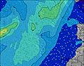 |  |  | 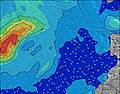 | 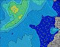 | |||||||||||||
Wave Height (m) Direction Period (s) | W 9 | W 10 | W 10 | W 10 | W 10 | W 10 | W 10 | W 10 | W 10 | W 9 | W 9 | NNE 10 | NNE 10 | NNE 10 | NNE 10 | W 9 | NNE 10 | NNE 10 | NNE 10 | NNE 10 | NNE 9 |
Wave Graph | |||||||||||||||||||||
142 | 145 | 183 | 186 | 184 | 186 | 220 | 219 | 214 | 170 | 166 | 205 | 218 | 214 | 210 | 201 | 205 | 214 | 214 | 205 | 177 | |
Wind (km/h) | |||||||||||||||||||||
Wind State on-shore cross-onshore cross-shore cross-offshore off-shore glassy | cross-on | glassy | cross-off | off | off | cross-off | cross-off | cross-off | cross-off | cross-off | cross-off | cross-off | cross-off | cross-off | cross-off | cross-off | cross-off | cross-off | cross-off | cross-off | cross-off |
High Tide | 5:04PM1.19m | 5:27AM1.06m | 5:45PM1.14m | 6:16AM1.01m | 6:37PM1.07m | ||||||||||||||||
Low Tide | 10:46AM0.18m | 11:21PM0.19m | 11:27AM0.24m | 00:05AM0.23m | 12:18PM0.30m | ||||||||||||||||
6:56 | — | — | — | — | — | — | 6:58 | — | — | — | — | — | — | — | 6:58 | — | — | — | — | — | |
— | — | — | — | 9:04 | — | — | — | — | — | — | — | 9:02 | — | — | — | — | — | — | — | 9:00 | |
mm | — | — | — | — | 1 | 1 | 1 | 1 | — | — | — | — | 1 | — | 1 | — | — | — | — | 1 | — |
Temp °C | 21 | 22 | 22 | 23 | 23 | 23 | 23 | 23 | 22 | 22 | 22 | 22 | 22 | 22 | 22 | 22 | 22 | 22 | 23 | 23 | 23 |
Feels °C | 22 | 24 | 23 | 24 | 24 | 24 | 24 | 24 | 24 | 23 | 22 | 22 | 22 | 22 | 22 | 22 | 22 | 22 | 23 | 23 | 23 |
Swell 1 Height (m) Direction Period (s) | W 9 | W 10 | W 10 | W 10 | N 9 | N 9 | W 10 | W 10 | W 10 | W 9 | NNE 8 | NNE 10 | NNE 10 | W 9 | W 9 | W 9 | NNE 10 | NNE 10 | NNE 10 | NNE 10 | NNE 9 |
142 | 145 | 183 | 186 | 150 | 146 | 220 | 219 | 214 | 170 | 154 | 205 | 218 | 189 | 185 | 185 | 205 | 214 | 214 | 205 | 177 | |
Swell 2 Height (m) Direction Period (s) | NNW 7 | N 9 | N 9 | N 9 | W 10 | W 10 | N 8 | N 8 | N 8 | N 8 | W 9 | W 9 | S 13 | NNE 10 | NNE 10 | NNE 9 | W 9 | W 9 | S 12 | S 12 | W 8 |
29 | 78 | 101 | 152 | 184 | 186 | 143 | 140 | 140 | 140 | 166 | 162 | 12 | 214 | 210 | 201 | 185 | 153 | 11 | 11 | 115 | |
Swell 3 Height (m) Direction Period (s) | N 9 | NNW 6 | NNW 6 | S 14 | S 14 | S 14 | S 12 | S 12 | S 12 | S 12 | S 12 | S 12 | S 16 | S 13 | S 12 | S 12 | S 12 | S 12 | S 15 | S 14 | S 12 |
59 | 26 | 15 | 15 | 15 | 14 | 12 | 12 | 12 | 12 | 12 | 12 | 5 | 12 | 3 | 11 | 11 | 11 | 4 | 4 | 11 | |
Wind waves Height (m) Direction Period (s) | — | — | — | S 4 | S 7 | SW 3 | SW 4 | SW 4 | SW 4 | SW 4 | SSW 4 | WSW 2 | W 9 | WSW 9 | SSW 4 | S 4 | SSW 4 | S 4 | W 9 | W 9 | SSW 4 |
— | — | — | 1 | 1 | 2 | 3 | 3 | 4 | 4 | 3 | 1 | 194 | 47 | 6 | 3 | 7 | 1 | 158 | 154 | 15 | |
Nearest Offshore or Glassy | |||||||||||||||||||||
Distance (km) | 14 | 0 | 0 | 0 | 0 | 14 | 70 | 70 | 0 | 70 | 73 | 70 | 70 | 70 | 70 | 70 | 70 | 70 | 70 | 70 | 70 |
Best forecast wave conditions in The Azores | |||||||||||||||||||||
Best forecast wave conditions in Portugal | |||||||||||||||||||||
Header Global | |||||||||||||||||||||
- Map Icons:
 Break
Break Live Wave Height (m)
 Live Wind Speed (km/h)
 Surf Rating (10 Max)
 Ocean Swells (m)
- Wind Speed (km/h)
Latest Updates


FREE! Surf-Forecast.com widget for your website
The surf report / weather widget below is available to embed on third party websites free of charge and provides a summary of our Faial - Praia do Norte surf forecast. Simply grab the html code snippet that we provide and paste it into your own site. You can choose your preferred language and metric/imperial units for the surf forecast feed to suit users of your site. Click here to get the code.
 Nearest