

Surf Forecasts:

How big are the waves at Manapany today (03 Aug):
- Morning surf: Morning surf (03 Aug, local time) - 8ft (2.5m), 9s period with E swell.
- Afternoon surf: Afternoon surf (03 Aug, local time) - 7.5ft (2.3m), 9s period with E swell.
- Evening surf: Evening surf (03 Aug, local time) - 7ft (2.1m), 9s period with E swell.
The current surf forecast for Manapany at 3PM is: 2.3m 9s primary swell from a East direction and 0.8m 16s secondary swell from a South direction (forecast issued at 09:00am August 03). An open ocean swell of 1.1m 14s is not directed at the surf break. The wind direction is predicted to be cross-shore.
| Time (+04) & Date | Wave Height | Wave Period |
|---|---|---|
| Morning (03 Aug) | 8ft (2.5m) | 9s |
| Afternoon (03 Aug) | 7.5ft (2.3m) | 9s |
| Evening (03 Aug) | 7ft (2.1m) | 9s |
Table - waves today at Manapany. (Swell directed towards the surf break)
Short Range ForecastLight rain (total 2mm), mostly falling on Wed afternoon. Warm (max 24°C on Mon morning, min 21°C on Wed night). Wind will be generally light. | ||||||||||||||||||||||
Monday 3 | Tuesday 4 | Wednesday 5 | ||||||||||||||||||||
7 AM | 10 AM | 1 PM | 4 PM | 7 PM | 10 PM | 1 AM | 4 AM | 7 AM | 10 AM | 1 PM | 4 PM | 7 PM | 10 PM | 1 AM | 4 AM | 7 AM | 10 AM | 1 PM | 4 PM | 7 PM | 10 PM | |
Swell Height Map |  | 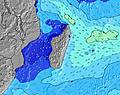 | 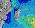 | 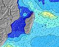 | 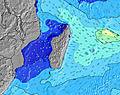 | 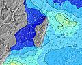 | 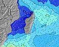 | 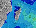 | ||||||||||||||
Wave Height (m) Direction Period (s) | E 9 | E 9 | E 9 | E 9 | E 9 | E 9 | E 9 | E 9 | E 9 | E 9 | E 9 | E 9 | E 9 | E 9 | E 10 | E 10 | E 10 | E 10 | E 10 | E 10 | E 9 | E 9 |
Wave Graph | ||||||||||||||||||||||
1021 | 1104 | 937 | 861 | 788 | 702 | 707 | 718 | 734 | 680 | 665 | 734 | 880 | 899 | 882 | 900 | 832 | 745 | 745 | 858 | 912 | 818 | |
Wind (km/h) | ||||||||||||||||||||||
Wind State on-shore cross-onshore cross-shore cross-offshore off-shore glassy | cross-off | cross-off | cross-off | cross-off | cross-off | cross-off | cross-off | cross-off | cross-off | cross | cross | cross | cross | cross | cross-off | cross-off | cross-off | cross | cross | cross-off | cross | cross |
High Tide | 3:14PM0.59m | 3:13AM0.57m | 3:48PM0.57m | 3:53AM0.50m | 4:31PM0.53m | |||||||||||||||||
Low Tide | 8:57AM0.09m | 9:13PM0.17m | 9:26AM0.13m | 9:55PM0.20m | 10:01AM0.18m | |||||||||||||||||
6:48 | — | — | — | — | — | — | 6:48 | — | — | — | — | — | — | — | 6:47 | — | — | — | — | — | — | |
— | — | — | 5:59 | — | — | — | — | — | — | — | 5:59 | — | — | — | — | — | — | — | 5:59 | — | — | |
mm | — | — | — | — | — | — | — | — | — | — | — | — | — | — | — | — | — | — | — | 1 | 1 | — |
Temp °C | 22 | 23 | 24 | 24 | 23 | 23 | 22 | 22 | 22 | 23 | 24 | 23 | 23 | 23 | 22 | 22 | 22 | 24 | 24 | 23 | 22 | 22 |
Feels °C | 21 | 22 | 23 | 23 | 22 | 22 | 20 | 21 | 21 | 22 | 23 | 22 | 23 | 22 | 21 | 21 | 21 | 23 | 23 | 23 | 21 | 21 |
Swell 1 Height (m) Direction Period (s) | SW 14 | SW 14 | SW 14 | SW 13 | SW 13 | SW 13 | SW 13 | S 14 | E 9 | SW 13 | S 13 | S 13 | S 13 | S 12 | E 10 | E 10 | E 10 | E 10 | E 10 | SW 15 | SSW 14 | SSW 14 |
706 | 565 | 478 | 451 | 340 | 246 | 246 | 198 | 734 | 161 | 168 | 215 | 153 | 143 | 882 | 900 | 832 | 745 | 745 | 318 | 367 | 352 | |
Swell 2 Height (m) Direction Period (s) | S 18 | S 18 | S 17 | S 16 | S 16 | S 15 | S 15 | SW 13 | SW 13 | S 13 | SW 12 | SW 12 | SW 12 | SW 12 | S 12 | SSW 15 | SW 15 | SSW 15 | SSW 15 | S 11 | S 11 | S 11 |
627 | 492 | 368 | 330 | 248 | 221 | 209 | 168 | 168 | 171 | 151 | 73 | 92 | 90 | 103 | 154 | 232 | 287 | 387 | 40 | 37 | 37 | |
Swell 3 Height (m) Direction Period (s) | S 18 | — | S 10 | S 10 | S 10 | S 10 | S 10 | S 10 | S 13 | SSE 10 | SSE 9 | SSE 9 | SW 16 | SSW 16 | SSW 16 | S 12 | S 12 | S 12 | S 12 | S 11 | S 11 | S 11 |
627 | — | 8 | 18 | 19 | 19 | 17 | 17 | 176 | 33 | 17 | 17 | 68 | 104 | 173 | 102 | 100 | 100 | 69 | 2 | 37 | 37 | |
Wind waves Height (m) Direction Period (s) | E 9 | E 9 | E 9 | E 9 | E 9 | E 9 | E 9 | E 9 | — | E 9 | E 9 | E 9 | E 9 | E 9 | — | — | — | — | — | E 10 | E 9 | E 9 |
1021 | 1104 | 937 | 861 | 788 | 702 | 707 | 718 | — | 680 | 665 | 734 | 880 | 899 | — | — | — | — | — | 858 | 912 | 818 | |
Nearest Offshore or Glassy | ||||||||||||||||||||||
Distance (km) | 11 | 11 | 29 | 15 | 15 | 15 | 15 | 11 | 11 | 29 | 29 | 29 | 15 | 15 | 15 | 15 | 15 | 15 | 53 | 15 | 15 | 15 |
Best forecast wave conditions in Réunion Island | ||||||||||||||||||||||
Best forecast wave conditions in Reunion | ||||||||||||||||||||||
Header Global | ||||||||||||||||||||||
- Map Icons:
 Break
Break Live Wave Height (m)
 Live Wind Speed (km/h)
 Surf Rating (10 Max)
 Ocean Swells (m)
- Wind Speed (km/h)
Latest Updates


FREE! Surf-Forecast.com widget for your website
The surf report / weather widget below is available to embed on third party websites free of charge and provides a summary of our Manapany surf forecast. Simply grab the html code snippet that we provide and paste it into your own site. You can choose your preferred language and metric/imperial units for the surf forecast feed to suit users of your site. Click here to get the code.
 Nearest