

Surf Forecasts:

How big are the waves at Anakena today (03 Aug):
- Morning surf: Morning surf (03 Aug, local time) - 5ft (1.6m), 17s period with SW swell.
- Afternoon surf: Afternoon surf (03 Aug, local time) - 8ft (2.5m), 16s period with SW swell.
- Evening surf: Evening surf (03 Aug, local time) - 8ft (2.5m), 16s period with SW swell.
The current surf forecast for Anakena at 6AM is: 1.6m 13s primary swell from a Southwest direction and 2.1m 7s secondary swell from a Northwest direction (forecast issued at 11:00pm August 02). The wind direction is predicted to be cross-onshore.
| Time (-06) & Date | Wave Height | Wave Period |
|---|---|---|
| Morning (03 Aug) | 5ft (1.6m) | 17s |
| Afternoon (03 Aug) | 8ft (2.5m) | 16s |
| Evening (03 Aug) | 8ft (2.5m) | 16s |
Table - waves today at Anakena. (Swell directed towards the surf break)
Short Range ForecastHeavy rain (total 87mm), heaviest during Sun night. Warm (max 21°C on Sun night, min 17°C on Wed morning). Winds increasing (light winds from the W on Mon morning, near gales from the ESE by Wed morning). | |||||||||||||||||
Monday 3 | Tuesday 4 | ||||||||||||||||
9 PM | 12 AM | 3 AM | 6 AM | 9 AM | 12 PM | 3 PM | 6 PM | 9 PM | 12 AM | 3 AM | 6 AM | 9 AM | 12 PM | 3 PM | 6 PM | 9 PM | |
Swell Height Map |  | 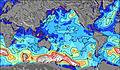 | 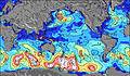 | 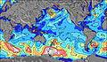 | 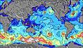 | 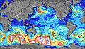 | 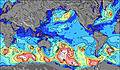 | ||||||||||
Wave Height (m) Direction Period (s) | WSW 11 | NNW 6 | SW 16 | SW 13 | SW 17 | SW 16 | SW 16 | SW 16 | SW 16 | SW 15 | SW 15 | SW 14 | SW 14 | NNW 7 | N 6 | SW 14 | SW 13 |
Wave Graph | |||||||||||||||||
325 | 274 | 776 | 828 | 1471 | 3336 | 3343 | 3059 | 3021 | 2590 | 2061 | 1761 | 1626 | 51 | 31 | 990 | 769 | |
Wind (km/h) | |||||||||||||||||
Wind State on-shore cross-onshore cross-shore cross-offshore off-shore glassy | cross-on | on | cross-on | cross-on | cross-on | cross-off | off | off | off | cross-off | cross-off | off | cross-off | cross-off | cross-off | cross-off | cross-off |
High Tide | 11:01PM0.57m | 10:51AM0.60m | 11:46PM0.64m | 11:40AM0.60m | |||||||||||||
Low Tide | 4:51AM0.35m | 5:16PM0.26m | 5:54AM0.30m | 5:50PM0.22m | |||||||||||||
— | — | — | 7:56 | — | — | — | — | — | — | — | 7:54 | — | — | — | — | — | |
— | — | — | — | — | — | — | 6:50 | — | — | — | — | — | — | — | 6:51 | — | |
mm | 4 | 7 | 16 | 2 | 3 | 2 | — | 1 | 1 | 2 | 2 | 2 | 1 | 2 | 2 | 3 | 4 |
Temp °C | 21 | 21 | 18 | 18 | 18 | 18 | 19 | 19 | 19 | 19 | 18 | 18 | 19 | 19 | 18 | 18 | 18 |
Feels °C | 15 | 15 | 15 | 16 | 19 | 18 | 17 | 18 | 16 | 14 | 12 | 11 | 12 | 12 | 10 | 9 | 8 |
Swell 1 Height (m) Direction Period (s) | SSW 11 | SSW 11 | SW 13 | NW 7 | NW 7 | SW 16 | SW 16 | SW 16 | SW 16 | SW 15 | SW 15 | SW 14 | SW 14 | SW 14 | SW 14 | SW 14 | SW 13 |
411 | 323 | 623 | 470 | 381 | 3336 | 3343 | 3059 | 3021 | 2590 | 2061 | 1761 | 1626 | 1512 | 1285 | 990 | 769 | |
Swell 2 Height (m) Direction Period (s) | WSW 11 | SSW 15 | SW 16 | SW 13 | SW 13 | NW 7 | NW 7 | SSE 8 | NNW 7 | NNW 7 | NNW 7 | NNW 7 | NNW 7 | NNW 7 | N 6 | S 16 | S 11 |
325 | 334 | 776 | 828 | 996 | 309 | 318 | 512 | 279 | 202 | 188 | 148 | 105 | 51 | 31 | 45 | 63 | |
Swell 3 Height (m) Direction Period (s) | SW 18 | WSW 11 | S 7 | S 8 | SW 17 | S 8 | SSE 8 | NNW 8 | W 11 | N 10 | — | — | — | — | NNW 10 | NNW 10 | NNW 12 |
255 | 176 | 52 | 248 | 1471 | 233 | 380 | 306 | 9 | 18 | — | — | — | — | 10 | 11 | 14 | |
Wind waves Height (m) Direction Period (s) | NNW 5 | NNW 6 | NW 7 | — | — | — | SSE 8 | SSE 8 | SSE 8 | SSE 9 | SE 9 | SE 9 | SE 9 | SE 9 | SE 9 | SE 9 | SE 10 |
109 | 274 | 639 | — | — | — | 583 | 717 | 857 | 1350 | 1660 | 1636 | 1585 | 1684 | 2112 | 2918 | 3043 | |
Nearest Offshore or Glassy | |||||||||||||||||
Distance (km) | 3634 | 3634 | 3634 | 3588 | 1 | 0 | 0 | 0 | 0 | 3526 | 3526 | 3541 | 3541 | 3541 | 3526 | 3526 | 3526 |
Best forecast wave conditions in Easter Island | |||||||||||||||||
Best forecast wave conditions in Chile | |||||||||||||||||
Header Global | |||||||||||||||||
- Map Icons:
 Break
Break Live Wave Height (m)
 Live Wind Speed (km/h)
 Surf Rating (10 Max)
 Ocean Swells (m)
- Wind Speed (km/h)
Latest Updates


FREE! Surf-Forecast.com widget for your website
The surf report / weather widget below is available to embed on third party websites free of charge and provides a summary of our Anakena surf forecast. Simply grab the html code snippet that we provide and paste it into your own site. You can choose your preferred language and metric/imperial units for the surf forecast feed to suit users of your site. Click here to get the code.
 Nearest