

Playa Santa Catalina Surf Guide
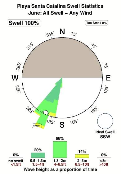
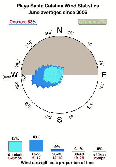
PlayaSanta Catalina in Golfo de Chiriqui is an exposed point break that has very consistent surf Works best in offshore winds from the north. Clean groundswells prevail and the best swell direction is from the south southwest. Sometimes crowded. Hazards include urchins and rocks.
Playa Santa Catalina Spot Info
| Type: | Rating: | Reliability: | Todays Sea Temp*: |
|---|---|---|---|
| very consistent | 29.3°C*ocean temperature recorded from satellite |
Surfing Playa Santa Catalina:
The best conditions reported for surf at Playa Santa Catalina occur when a South-southwest swell combines with an offshore wind direction from the North.
What's the best time of year to surf Playa Santa Catalina (for consistent clean waves)?
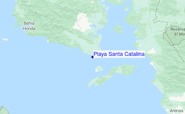
Explore Playa Santa Catalina Location Map
Interactive Playa Santa Catalina surf break location map. View information about nearby surf breaks, their wave consistency and rating compared to other spots in the region. Current swell conditions from local buoys are shown along with live wind speed and direction from nearby weather stations. Click icons on the map for more detail. The nearest passenger airport to Playa Santa Catalina is Enrique Malek International (David) Airport (DAV) in Panama, which is 158 km (98 miles) away (directly). The second closest airport to Playa Santa Catalina is Coto 47 Airport (OTR) in Costa Rica, 220 km (137 miles) away.
- Map Icons:
 Break
Break Live Wave Height (m)
 Live Wind Speed (km/h)
 Surf Rating (10 Max)
 Ocean Swells (m)
- Wind Speed (km/h)
Monday, 22 June 2026, 13:51 Local Time
| Monday 22 | ||||
| 10AM | 1PM | 4PM | 7PM | |
| Wave (m) | ||||
| Period (s) | 16 | 16 | 16 | 16 |
| Wind (km/h) | ||||
| Wind State | cross- off |
cross | cross- on |
cross- on |
Tides at Playa Santa Catalina
| NEXT | IS AT (local time) | remaining |
|---|---|---|
| high tide | ||
| low tide |
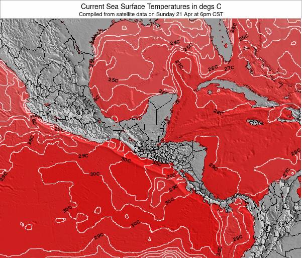
Playa Santa Catalina Sea Temperature
Very warm air temperatures and very warm water(29.3 °C) too at Playa Santa Catalina, warm enough for wearing board shorts and a rash vest in the surf. Cloudy, but feeling very pleasant in and out of the water.
Swell History at Playa Santa Catalina
Surf stats for Playa Santa Catalina, see the swell variation by month or season on the history page here.

Wind History at Playa Santa Catalina
Wind stats for Playa Santa Catalina, see the variation in direction and stength by month or season on the history page here.
Other Nearby Breaks Closest To:
Discover surf breaks near Playa Santa Catalina. Click below to view there surf guides.
 Nearest