

Surf Forecasts:

How big are the waves at Funingwan today (03 Aug):
- Morning surf: Morning surf (03 Aug, local time) - 1ft (0.3m), 16s period with ESE swell.
- Afternoon surf: Afternoon surf (03 Aug, local time) - 1.5ft (0.4m), 16s period with ESE swell.
- Evening surf: Evening surf (03 Aug, local time) - 1.5ft (0.4m), 15s period with ESE swell.
The current surf forecast for Funingwan at 1PM is: 0.3m 15s primary swell from a East-southeast direction and 0.2m 9s secondary swell from a East-southeast direction (forecast issued at 07:00am August 03). The wind direction is predicted to be cross-onshore.
| Time (CST) & Date | Wave Height | Wave Period |
|---|---|---|
| Morning (03 Aug) | 1ft (0.3m) | 16s |
| Afternoon (03 Aug) | 1.5ft (0.4m) | 16s |
| Evening (03 Aug) | 1.5ft (0.4m) | 15s |
Table - waves today at Funingwan. (Swell directed towards the surf break)
Short Range ForecastSome drizzle, heaviest during Wed afternoon. Warm (max 30°C on Mon afternoon, min 25°C on Mon night). Wind will be generally light. | |||||||||||||||||||||||
Monday 3 | Tuesday 4 | Wednesday 5 | |||||||||||||||||||||
5 AM | 8 AM | 11 AM | 2 PM | 5 PM | 8 PM | 11 PM | 2 AM | 5 AM | 8 AM | 11 AM | 2 PM | 5 PM | 8 PM | 11 PM | 2 AM | 5 AM | 8 AM | 11 AM | 2 PM | 5 PM | 8 PM | 11 PM | |
Swell Height Map | 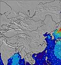 | 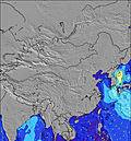 | 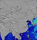 | 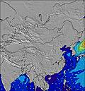 | 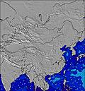 | 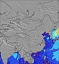 | 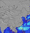 | 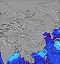 | 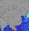 | ||||||||||||||
Wave Height (m) Direction Period (s) | ESE 17 | ESE 17 | ESE 15 | SE 16 | ESE 16 | ESE 15 | ESE 15 | ESE 15 | ESE 15 | ESE 16 | ESE 16 | ESE 16 | ESE 16 | ESE 17 | ESE 17 | ESE 17 | ESE 17 | ESE 17 | ESE 17 | ESE 17 | ESE 17 | ESE 17 | ESE 17 |
Wave Graph | |||||||||||||||||||||||
28 | 57 | 45 | 61 | 94 | 87 | 85 | 87 | 135 | 144 | 142 | 226 | 237 | 237 | 267 | 340 | 333 | 321 | 325 | 321 | 313 | 404 | 433 | |
Wind (km/h) | |||||||||||||||||||||||
Wind State on-shore cross-onshore cross-shore cross-offshore off-shore glassy | glassy | glassy | glassy | cross-on | on | glassy | cross | cross-on | cross | cross | on | on | on | cross-on | cross | cross-off | cross-off | cross | cross-on | cross-on | cross-on | cross-on | cross |
High Tide | 12:28PM5.16m | 00:52AM5.28m | 1:11PM5.01m | 1:28AM5.10m | 2:01PM4.82m | ||||||||||||||||||
Low Tide | 6:40AM0.98m | 6:53PM0.83m | 7:19AM1.00m | 7:33PM1.16m | 8:01AM1.07m | 8:19PM1.55m | |||||||||||||||||
5:24 | — | — | — | — | — | — | — | 5:24 | — | — | — | — | — | — | — | 5:24 | — | — | — | — | — | — | |
— | — | — | — | 6:45 | — | — | — | — | — | — | — | 6:45 | — | — | — | — | — | — | — | 6:45 | — | — | |
mm | — | — | — | — | — | — | — | — | — | — | — | — | — | — | — | — | — | — | — | 1 | — | — | — |
Temp °C | 26 | 27 | 29 | 30 | 29 | 27 | 26 | 26 | 25 | 26 | 28 | 29 | 28 | 26 | 26 | 26 | 26 | 28 | 30 | 29 | 29 | 27 | 27 |
Feels °C | 30 | 31 | 33 | 33 | 33 | 32 | 30 | 30 | 28 | 30 | 31 | 32 | 31 | 30 | 30 | 29 | 29 | 31 | 33 | 30 | 32 | 31 | 31 |
Swell 1 Height (m) Direction Period (s) | ESE 17 | ESE 17 | ESE 15 | SE 16 | ESE 16 | ESE 15 | ESE 15 | ESE 15 | ESE 15 | ESE 16 | ESE 16 | ESE 16 | ESE 16 | ESE 17 | ESE 17 | ESE 17 | ESE 17 | ESE 17 | ESE 17 | ESE 17 | ESE 17 | ESE 17 | ESE 17 |
28 | 57 | 45 | 61 | 94 | 87 | 85 | 87 | 135 | 144 | 142 | 226 | 237 | 237 | 267 | 340 | 333 | 321 | 325 | 321 | 313 | 404 | 433 | |
Swell 2 Height (m) Direction Period (s) | SE 9 | ESE 9 | ESE 9 | ESE 9 | ESE 9 | ESE 9 | ESE 9 | ESE 9 | ESE 3 | ESE 7 | SE 4 | S 7 | S 7 | E 6 | — | ENE 3 | — | ENE 4 | — | — | — | — | ENE 5 |
3 | 8 | 8 | 8 | 8 | 8 | 8 | 8 | 1 | 4 | 3 | 1 | 1 | 1 | — | 2 | — | 3 | — | — | — | — | 14 | |
Swell 3 Height (m) Direction Period (s) | SE 6 | S 7 | S 7 | S 7 | S 7 | — | — | ESE 3 | S 7 | S 7 | SE 7 | S 7 | — | — | — | — | — | — | — | — | — | — | — |
1 | 1 | 1 | 1 | 1 | — | — | 1 | 1 | 1 | 2 | 1 | — | — | — | — | — | — | — | — | — | — | — | |
Wind waves Height (m) Direction Period (s) | — | — | — | — | ESE 3 | ESE 3 | — | — | — | — | — | — | ESE 3 | ESE 4 | E 3 | — | — | NE 4 | ENE 4 | ENE 5 | ENE 5 | ENE 5 | NE 5 |
— | — | — | — | 1 | 1 | — | — | — | — | — | — | 2 | 2 | 2 | — | — | 8 | 6 | 38 | 28 | 19 | 22 | |
Nearest Offshore or Glassy | |||||||||||||||||||||||
Distance (km) | 216 | 216 | 759 | 759 | 538 | 281 | 265 | 265 | 265 | 271 | 538 | 500 | 538 | 276 | 265 | 0 | 0 | 229 | 271 | 500 | 271 | 271 | 271 |
Best forecast wave conditions in Fujian | |||||||||||||||||||||||
Best forecast wave conditions in China | |||||||||||||||||||||||
Header Global | |||||||||||||||||||||||
- Map Icons:
 Break
Break Live Wave Height (m)
 Live Wind Speed (km/h)
 Surf Rating (10 Max)
 Ocean Swells (m)
- Wind Speed (km/h)
Latest Updates


FREE! Surf-Forecast.com widget for your website
The surf report / weather widget below is available to embed on third party websites free of charge and provides a summary of our Funingwan surf forecast. Simply grab the html code snippet that we provide and paste it into your own site. You can choose your preferred language and metric/imperial units for the surf forecast feed to suit users of your site. Click here to get the code.
 Nearest